Difference between revisions of "Civilisation/World Geography - Asia"
(Added content) |
(Brought up to date) |
||
| (15 intermediate revisions by the same user not shown) | |||
| Line 1: | Line 1: | ||
| − | [[File:Map of Asia.png|none|thumb]] | + | [[File:Map of Asia.png|none|thumb|alt=|600x600px]] |
== Afghanistan == | == Afghanistan == | ||
| Line 30: | Line 30: | ||
Minaret of Jam is a World Heritage Site | Minaret of Jam is a World Heritage Site | ||
| + | |||
| + | River Helmand is the largest river in Afghanistan | ||
| + | |||
| + | Durand Line refers to the international border established between Pakistan and Afghanistan in 1896. It is named after Mortimer Durand who was the Foreign Secretary of colonial British India at the time | ||
== Bahrain == | == Bahrain == | ||
| Line 72: | Line 76: | ||
Most of Bangladesh is dominated by the fertile Ganges-Brahmaputra delta | Most of Bangladesh is dominated by the fertile Ganges-Brahmaputra delta | ||
| − | Dhaka is the | + | Dhaka is the ninth largest city in the world, with a population of more than 22 million people in the Greater Dhaka Area |
Jativa Sangsad Bhaban is the National Parliament Building of Bangladesh | Jativa Sangsad Bhaban is the National Parliament Building of Bangladesh | ||
| Line 124: | Line 128: | ||
Brunei gained its independence from the United Kingdom in 1984 | Brunei gained its independence from the United Kingdom in 1984 | ||
| + | |||
| + | Temburong District is the easternmost district in Brunei. It is an exclave and is separated from the rest of the country by Malaysia and Brunei Bay, and accessible from the mainland via the Sultan Haji Omar Ali Saifuddien Bridge. | ||
| + | |||
| + | Brunei is formally known as Brunei Darussalam (‘Abode of Peace’) | ||
As a Sharia country, the sale and public consumption of alcohol is banned | As a Sharia country, the sale and public consumption of alcohol is banned | ||
| Line 149: | Line 157: | ||
Angkor Wat (‘city temple’) was built for the king Suryavarman II in the early 12th century as his state temple and capital city. As the best-preserved temple at the site, it is the only one to have remained a significant religious centre since its foundation – first Hindu, dedicated to the god Vishnu, then Buddhist. It is the world's largest religious building. The temple is at the top of the high classical style of Khmer architecture | Angkor Wat (‘city temple’) was built for the king Suryavarman II in the early 12th century as his state temple and capital city. As the best-preserved temple at the site, it is the only one to have remained a significant religious centre since its foundation – first Hindu, dedicated to the god Vishnu, then Buddhist. It is the world's largest religious building. The temple is at the top of the high classical style of Khmer architecture | ||
| − | Angkor Thom (‘great city’) was the last and most enduring capital city of the Khmer empire. It was established in the late | + | Angkor Thom (‘great city’) was the last and most enduring capital city of the Khmer empire. It was established in the late 12th century by king Jayavarman VII |
Tonle Sap is unusual for two reasons: its flow changes direction twice a year, and the portion that forms the lake expands and shrinks dramatically with the seasons. From November to May, Cambodia's dry season, the Tonle Sap drains into the Mekong River at Phnom Penh. However, when the year's heavy rains begin in June, the Tonle Sap backs up to form an enormous lake | Tonle Sap is unusual for two reasons: its flow changes direction twice a year, and the portion that forms the lake expands and shrinks dramatically with the seasons. From November to May, Cambodia's dry season, the Tonle Sap drains into the Mekong River at Phnom Penh. However, when the year's heavy rains begin in June, the Tonle Sap backs up to form an enormous lake | ||
| Line 167: | Line 175: | ||
|- | |- | ||
|Largest cities | |Largest cities | ||
| − | |Shanghai, Beijing, | + | |Shanghai, Beijing, Guangzhou, Shenzhen, Tianjin |
|- | |- | ||
|Currency | |Currency | ||
| Line 176: | Line 184: | ||
|} | |} | ||
Note: The renminbi is the official currency of China where it acts as a medium of exchange, the yuan is the unit of account of the country's economic and financial system | Note: The renminbi is the official currency of China where it acts as a medium of exchange, the yuan is the unit of account of the country's economic and financial system | ||
| − | [[File:Map of China (en).png|none|thumb]] | + | [[File:Map of China (en).png|none|thumb|alt=|710x710px]] |
China is the world's second-largest country by land area | China is the world's second-largest country by land area | ||
| − | China is the world's most populous country, with a population of over 1.4 billion | + | China is the world's second-most populous country, with a population of over 1.4 billion |
China borders 14 countries | China borders 14 countries | ||
| Line 195: | Line 203: | ||
Most populous administrative divisions (in 2020) – Guangdong (126 million), Shandong (101 million), Henan (99 million) | Most populous administrative divisions (in 2020) – Guangdong (126 million), Shandong (101 million), Henan (99 million) | ||
| − | Forbidden City was the Chinese imperial palace from the Ming Dynasty to the end of the Qing Dynasty. It is located in the middle of | + | '''Beijing''' has a population of over 19 million |
| + | |||
| + | Forbidden City was the Chinese imperial palace from the Ming Dynasty to the end of the Qing Dynasty. It is located in the middle of Beijing, and now houses the Palace Museum. For almost 500 years, it served as the home of emperors and their households, as well as the ceremonial and political centre of Chinese government. Built in 1406 to 1420, the complex consists of 980 buildings and covers 720,000 m<sup>2</sup> | ||
Summer Palace in Beijing is mainly dominated by Longevity Hill and the Kunming Lake | Summer Palace in Beijing is mainly dominated by Longevity Hill and the Kunming Lake | ||
| Line 217: | Line 227: | ||
Shanghai is situated on the banks of the Yangtze River Delta | Shanghai is situated on the banks of the Yangtze River Delta | ||
| − | Shanghai's rapid transit system, Shanghai Metro, incorporates both subway and light railway lines. There are 19 metro lines (including the Shanghai Maglev Train), | + | Shanghai's rapid transit system, Shanghai Metro, incorporates both subway and light railway lines. There are 19 metro lines (including the Shanghai Maglev Train), 408 stations and over 800 km of tracks in operation, making it the longest network in the world |
Shanghai is the world’s busiest port in terms of total cargo tonnage | Shanghai is the world’s busiest port in terms of total cargo tonnage | ||
The traditional area of Pudong is now home to the Lujiazui Finance and Trade Zone and the Shanghai Stock Exchange and many of Shanghai's best-known buildings | The traditional area of Pudong is now home to the Lujiazui Finance and Trade Zone and the Shanghai Stock Exchange and many of Shanghai's best-known buildings | ||
| + | |||
| + | Oriental Pearl Radio & Television Tower is a distinctive landmark in Pudong | ||
Huangpu River flows through Shanghai | Huangpu River flows through Shanghai | ||
| Line 231: | Line 243: | ||
Thames Town is the English name for a new town in Songjiang District, about 30 kilometres from central Shanghai. The architecture is themed according to classic English market town styles | Thames Town is the English name for a new town in Songjiang District, about 30 kilometres from central Shanghai. The architecture is themed according to classic English market town styles | ||
| − | Guangdong is the most populous province of China | + | Guangdong is the most populous province of China |
Pearl River Delta in Guangdong province is one of the most densely urbanised regions in the world and one of the main hubs of China's economic growth | Pearl River Delta in Guangdong province is one of the most densely urbanised regions in the world and one of the main hubs of China's economic growth | ||
| − | Guangzhou is the capital and the sub-provincial city of Guangdong Province in the southern part of China. The city is also known by an older English-language name, Canton. It is a port on the Pearl River | + | '''Guangzhou''' is the capital and the sub-provincial city of Guangdong Province in the southern part of China. The city is also known by an older English-language name, Canton. It is a port on the Pearl River |
Pearl River Tower is a skyscraper in Guangzhou completed in 2011 | Pearl River Tower is a skyscraper in Guangzhou completed in 2011 | ||
| Line 245: | Line 257: | ||
Shenzhen is a major city in the south of Guangdong Province, situated immediately north of Hong Kong. The area became China's first Special Economic Zone | Shenzhen is a major city in the south of Guangdong Province, situated immediately north of Hong Kong. The area became China's first Special Economic Zone | ||
| − | Ping An International Finance Centre is a skyscraper | + | Ping An International Finance Centre is a skyscraper in Shenzhen. It was completed in 2017, and is the second tallest building in China |
| − | Chongqing is a major city in southwest China. The municipality has a population of 32 million | + | Chongqing is a major city in southwest China. The municipality has a population of 32 million and the urbanized area has a population of 9 million |
Chengdu is the provincial capital of Sichuan province in Southwest China. It has a breeding centre for giant pandas | Chengdu is the provincial capital of Sichuan province in Southwest China. It has a breeding centre for giant pandas | ||
| Line 254: | Line 266: | ||
Tianjin was ceded to nine foreign powers between 1860 and 1947 | Tianjin was ceded to nine foreign powers between 1860 and 1947 | ||
| − | |||
| − | |||
Harbin International Ice and Snow Sculpture Festival has been held since 1963 | Harbin International Ice and Snow Sculpture Festival has been held since 1963 | ||
| Line 273: | Line 283: | ||
Ningbo-Zhoushan is the busiest port in the world in terms of cargo tonnage | Ningbo-Zhoushan is the busiest port in the world in terms of cargo tonnage | ||
| − | The Shaolin Monastery is a Buddhist temple, in Henan province | + | The Shaolin Monastery is a Buddhist temple, in Henan province. Famous for its long association with Chan (Zen) Buddhism and martial arts, it is perhaps the Chan Buddhist monastery best known to the Western world |
| − | Spring Temple Buddha is a statue depicting Vairocana Buddha located in Henan, China. At 128 m, which includes a 20 m lotus throne, it | + | Spring Temple Buddha is a statue depicting Vairocana Buddha located in Henan, China. At 128 m, which includes a 20 m lotus throne, it was the tallest statue in the world until 2018 |
| − | Leshan Giant Buddha was built during the Tang Dynasty | + | Leshan Giant Buddha was built during the Tang Dynasty. It is carved out of a cliff face that lies at the confluence of the Minjiang, Dadu and Qingyi rivers in the southern part of Sichuan province |
Great Wall of China stretches from Shanhaiguan in the east, to Lop Lake in the west, along an arc that roughly delineates the southern edge of Inner Mongolia. The most comprehensive archaeological survey has concluded that all the walls measure 8,851 km (5,500 miles). One of the most famous is the wall built between 220–206 BC by the first Emperor of China, Qin Shi Huang. Little of that wall remains; the majority of the existing wall was built during the Ming Dynasty | Great Wall of China stretches from Shanhaiguan in the east, to Lop Lake in the west, along an arc that roughly delineates the southern edge of Inner Mongolia. The most comprehensive archaeological survey has concluded that all the walls measure 8,851 km (5,500 miles). One of the most famous is the wall built between 220–206 BC by the first Emperor of China, Qin Shi Huang. Little of that wall remains; the majority of the existing wall was built during the Ming Dynasty | ||
| Line 293: | Line 303: | ||
Dalian is a port city in Liaoning | Dalian is a port city in Liaoning | ||
| − | + | Zhengdhou is the capital of Henan Province | |
| − | + | Urumqi is the capital of the Xinjiang Uyghur Autonomous Region | |
| − | Xiamen | + | Xiamen was formerly known as Amoy. It is a city beside the Taiwan Strait |
| − | Sanxingdui is an archaeological site and a major Bronze Age culture in modern Sichuan | + | Sanxingdui is an archaeological site and a major Bronze Age culture in modern Sichuan |
| − | Porcelain Tower of Nanking is a reconstruction of a Ming Dynasty pagoda | + | Porcelain Tower of Nanking is a reconstruction of a Ming Dynasty pagoda |
| − | Datang in China is known as ‘Sock City’. The town produces 8 billion pairs of socks each year | + | Datang in China is known as ‘Sock City’. The town produces 8 billion pairs of socks each year |
| − | + | Ruyi Bridge in Zhejiang province is a glass-bottomed pedestrian bridge | |
| − | + | Giant Wild Goose Pagoda is a Buddhist pagoda in Xi’an | |
| − | + | Qiantang River and bay are known for the world's largest tidal bore | |
| − | |||
| − | |||
There are six national parks in China. Five are on Taiwan, including Takoro National Park. The only park on the mainland is Kinmen National Park | There are six national parks in China. Five are on Taiwan, including Takoro National Park. The only park on the mainland is Kinmen National Park | ||
| Line 319: | Line 327: | ||
Danyang–Kunshan Grand Bridge is the world's longest bridge. It is a 164 km long viaduct on the Beijing–Shanghai High-Speed Railway | Danyang–Kunshan Grand Bridge is the world's longest bridge. It is a 164 km long viaduct on the Beijing–Shanghai High-Speed Railway | ||
| − | The Grand Canal of China is the longest ancient canal or artificial river in the world. It passes through the cities of Beijing and Tianjin. The oldest parts of the canal date back to the 5th century BC. Grand Canal ends at Hangzhou | + | Mogao Caves, also known as the Thousand Buddha Grottoes or Caves of the Thousand Buddhas, form a system of 492 temples on the Silk Road, in Gansu province |
| + | |||
| + | Three-North Shelter Forest Program, also known as the Great Green Wall, is a series of human-planted windbreaking forest strips in China, designed to hold back the expansion of the Gobi Desert | ||
| + | |||
| + | The Grand Canal of China is the longest ancient canal or artificial river in the world. It passes through the cities of Beijing and Tianjin. The oldest parts of the canal date back to the 5th century BC. The Grand Canal ends at Hangzhou | ||
The Lingqu canal in China is the oldest existing canal in the world | The Lingqu canal in China is the oldest existing canal in the world | ||
| − | Three Parallel Rivers of Yunnan Protected Areas is a World Heritage Site. It lies within the drainage basins of the upper reaches of the Yangtze, Mekong and Salween rivers | + | Three Parallel Rivers of Yunnan Protected Areas is a UNESCO World Heritage Site. It lies within the drainage basins of the upper reaches of the Yangtze, Mekong and Salween rivers |
Yangtze River, or Chang Jiang, is the longest river in Asia and the longest river to flow through one country | Yangtze River, or Chang Jiang, is the longest river in Asia and the longest river to flow through one country | ||
| Line 329: | Line 341: | ||
Yellow River, or Huang He, is the second-longest river in China. Known as “China’s sorrow” due to floods | Yellow River, or Huang He, is the second-longest river in China. Known as “China’s sorrow” due to floods | ||
| − | + | Qinghai Lake is the largest lake in China. Located in Qinghai province, it is classified as a saline and alkaline lake | |
| − | + | Poyang Lake is the largest freshwater lake in China | |
Bohai Sea is the innermost gulf of the Yellow Sea | Bohai Sea is the innermost gulf of the Yellow Sea | ||
| + | |||
| + | Aksai Chin is a region administered by China. It is a part of the Kashmir region and has been a subject of dispute between India and China since the late 1950s | ||
<u>Autonomous regions</u> | <u>Autonomous regions</u> | ||
| Line 339: | Line 353: | ||
An autonomous region is a first-level administrative subdivision of China. The Inner Mongolia autonomous region was established in 1947; Xinjiang was made autonomous in 1955; Guangxi and Ningxia in 1958, and Tibet in 1965 | An autonomous region is a first-level administrative subdivision of China. The Inner Mongolia autonomous region was established in 1947; Xinjiang was made autonomous in 1955; Guangxi and Ningxia in 1958, and Tibet in 1965 | ||
| − | + | <u>Inner Mongolia</u> | |
| − | + | Xanadu, or more accurately Shangdu, was the summer capital of Kublai Khan's Yuan Dynasty in China, after he decided to move the capital of the Yuan Dynasty to Dadu, present-day Beijing | |
| − | + | Ordos Desert is in Inner Mongolia | |
| − | + | Hulunbuir is a prefecture-level city, and is the world’s largest city by area | |
| − | + | The mines north of Bayan Obo are the largest deposits of rare-earth metals yet found | |
| − | + | Tuoketuo Power Station is the largest coal-fired power station in the world | |
| − | |||
| − | |||
| − | |||
| − | + | <u>Xinjiang</u> | |
| − | + | Xinjiang is the largest autonomous community in China. It is home to a number of ethnic groups including the Uyghur | |
| − | + | Taklamakan Desert is a desert in southwest Xinjiang | |
| − | + | Turpan depression is a fault-bounded trough | |
| − | + | Urumqi is the capital of the Xinjiang. It is the most remote city from any sea in the world | |
| − | |||
| − | |||
| − | + | <u>Tibet</u> | |
| − | |||
| − | Macau lies on the western side of the Pearl River Delta across from Hong Kong, and it is also bordered by Guangdong Province to the north and the South China Sea to the east and south | + | Potala Palace was the chief residence of the Dalai Lama until the 14th Dalai Lama fled to India during the 1959 Tibetan uprising. It is now a museum and World Heritage Site. The White Palace is the part of the Potala Palace that makes up the living quarters of the Dalai Lama. The Red Palace is completely devoted to religious study and Buddhist prayer |
| + | |||
| + | There have been no recorded attempts to climb Mount Kailash; it is considered off limits to climbers in deference to Buddhist and Hindu beliefs. It is the most significant peak in the world that has not seen any known climbing attempts. Mount Kailash is the source of the Indus and Brahmaputra rivers | ||
| + | |||
| + | Larung Gar has a population of over 40,000 which comprises primarily monks and nuns making it possibly the largest religious institute in the world | ||
| + | |||
| + | Yarlong Tsangpo Grand Canyon is the deepest canyon in the world | ||
| + | |||
| + | === Hong Kong === | ||
| + | [[File:Flag-of-Hong-Kong.jpg|center|thumb]] | ||
| + | Flag of Hong Kong depicts a white stylised five-petal Hong Kong orchid tree (''Bauhinia blakeana'') | ||
| + | |||
| + | Hong Kong ("Fragrant Harbour"), officially known as Hong Kong Special Administrative Region of the People's Republic of China, is a city state with a high degree of autonomy on the southern coast of China at the Pearl River Estuary and the South China Sea | ||
| + | |||
| + | The territory's 1,104 km<sup>2</sup> area consists of Hong Kong Island, the Kowloon Peninsula, the New Territories, and over 200 offshore islands, of which the largest is Lantau Island | ||
| + | |||
| + | Hong Kong is one of the busiest container ports in the world | ||
| + | |||
| + | Stonecutters Bridge is a high level cable-stayed bridge which spans the Rambler Channel in Hong Kong, connecting Tsing Yi Island and Stonecutters Island. The bridge was the second-longest cable-stayed span in the world at the time of its completion in 2009 | ||
| + | |||
| + | The Star Ferry service, founded in 1888, operates two lines across Victoria Harbour. The ferry carries over 26 million passengers a year | ||
| + | |||
| + | Hong Kong International Airport is located on the island of Chek Lap Kok. It replaced the overcrowded Kai Tak Airport in Kowloon in 1998 | ||
| + | |||
| + | The International Commerce Centre (ICC), at 484 m high, is the tallest building in Hong Kong | ||
| + | |||
| + | Victoria Peak, the highest mountain on Hong Kong island, is a major tourist attraction | ||
| + | |||
| + | === Macau === | ||
| + | [[File:Flag of Macau.svg.png|center|thumb]] | ||
| + | Flag of Macau depicts a lotus flower | ||
| + | |||
| + | Macau is a Special Administrative Region of China. Macau was administered by Portugal from the 16th century until 1999 | ||
| + | |||
| + | Macau lies on the western side of the Pearl River Delta across from Hong Kong, and it is also bordered by Guangdong Province to the north and the South China Sea to the east and south | ||
Macau became the world's largest gambling centre in 2006. Casinos on the Cotai Strip include The Venetian Macau, City of Dreams, and Galaxy Macau | Macau became the world's largest gambling centre in 2006. Casinos on the Cotai Strip include The Venetian Macau, City of Dreams, and Galaxy Macau | ||
| Line 384: | Line 426: | ||
[[File:Flag-of-India.png|none|thumb]] | [[File:Flag-of-India.png|none|thumb]] | ||
Flag of India has the Ashoka Chakra, a 24-spoke wheel, at its centre | Flag of India has the Ashoka Chakra, a 24-spoke wheel, at its centre | ||
| − | [[File: | + | [[File:Political-map-of-india-.jpg|center|thumb|790x790px]] |
{| class="wikitable" | {| class="wikitable" | ||
|Capital | |Capital | ||
| Line 398: | Line 440: | ||
|Kangchenjunga | |Kangchenjunga | ||
|} | |} | ||
| − | India is the seventh largest country by area, and the second most populous country with over 1. | + | India is the seventh largest country by area, and the second most populous country with over 1.4 billion people |
| − | India | + | India overtook China in 2023 to become the most populous country |
India is a federation composed of 28 states and 8 union territories | India is a federation composed of 28 states and 8 union territories | ||
| Line 417: | Line 459: | ||
Patna is the state capital of '''Bihar''' | Patna is the state capital of '''Bihar''' | ||
| + | |||
| + | Bodh Gaya in Bihar is famous as it is the place where Gautama Buddha is said to have attained Enlightenment | ||
Panaji is the state capital of '''Goa''' | Panaji is the state capital of '''Goa''' | ||
| Line 428: | Line 472: | ||
Ahmedabad is the largest city of '''Gujarat''' | Ahmedabad is the largest city of '''Gujarat''' | ||
| − | Jamnagar Refinery is a private sector crude oil refinery owned by Reliance Industries in Jamnagar | + | Jamnagar Refinery is a private sector crude oil refinery owned by Reliance Industries in Jamnagar. The refinery was commissioned in 1999 with an installed capacity of 668,000 barrels per day. It is currently the largest refinery in the world |
| − | Statue of Unity is a 182 m monument of statesman and independence activist Sardar Patel | + | Statue of Unity is a 182 m monument of statesman and independence activist Sardar Patel. Completed in 2018, it is the tallest statue in the world |
| − | Surat is a city | + | Surat is a city famous for its diamonds and textile industries. It was formerly a large seaport |
Gir Forest National Park in Gujarat has a population of Asiatic lions | Gir Forest National Park in Gujarat has a population of Asiatic lions | ||
| Line 456: | Line 500: | ||
Bombay was renamed Mumbai in 1995 | Bombay was renamed Mumbai in 1995 | ||
| − | The metropolis of Mumbai and the city of Thane lie on Salsette Island, making it the | + | The metropolis of Mumbai and the city of Thane lie on Salsette Island, making it one of the most populous islands in the world |
Mumbai is bounded by the Arabian Sea to the west | Mumbai is bounded by the Arabian Sea to the west | ||
| Line 469: | Line 513: | ||
Nagpur is the seat of the annual winter session of the Maharashtra state assembly | Nagpur is the seat of the annual winter session of the Maharashtra state assembly | ||
| + | |||
| + | Pune is a city in Maharashtra. Previously known as Poona | ||
Ellora is an archaeological site in the Indian state of Maharashtra built by the Rashtrakuta Dynasty. Famous for its monumental caves, Ellora is a World Heritage Site | Ellora is an archaeological site in the Indian state of Maharashtra built by the Rashtrakuta Dynasty. Famous for its monumental caves, Ellora is a World Heritage Site | ||
| Line 476: | Line 522: | ||
'''Odisha''' (formerly Orissa, the official name until 2011), is a state located in Eastern India | '''Odisha''' (formerly Orissa, the official name until 2011), is a state located in Eastern India | ||
| − | + | Puri is a city in Odisha. It is one of the original Char Dham pilgrimage sites for Hindus | |
| − | + | '''Punjab''' shares an international border with Punjab, a province of Pakistan | |
| − | Amritsar was founded by Guru Ram Das in 1574 | + | Chandigarh is the state capital of Punjab |
| + | |||
| + | Amritsar was founded by Guru Ram Das in 1574. It is home the Golden Temple, one of Sikhism religion's most spiritually significant gurudwaras | ||
'''Rajasthan''' is the largest state by area | '''Rajasthan''' is the largest state by area | ||
| Line 488: | Line 536: | ||
Jaipur is known as the Pink City of India | Jaipur is known as the Pink City of India | ||
| − | Jantar Mantar Observatory in Jaipur contains 12 sundials. | + | Jantar Mantar Observatory in Jaipur contains 12 sundials. It was constructed by Jai Singh in the 18th century |
Jodhpur is the second largest city in Rajasthan. It is known as the ‘Sun City’ and the ‘Blue City’ | Jodhpur is the second largest city in Rajasthan. It is known as the ‘Sun City’ and the ‘Blue City’ | ||
| Line 506: | Line 554: | ||
Madurai is referred to as the ‘Athens of the East’ perhaps due to its monumental temples | Madurai is referred to as the ‘Athens of the East’ perhaps due to its monumental temples | ||
| − | In | + | In 2014, '''Telangana''' was separated from Andhra Pradesh as a new state of India, with the city of Hyderabad as its capital. Hyderabad served as the joint capital city for Andhra Pradesh and Telangana, until the new city of Amaravati was built in Andhra Pradesh |
'''Uttar Pradesh''' is the largest state by population | '''Uttar Pradesh''' is the largest state by population | ||
| Line 514: | Line 562: | ||
Allahabad is a city in Uttar Pradesh | Allahabad is a city in Uttar Pradesh | ||
| − | United Provinces | + | Uttar Pradesh was formerly known as United Provinces |
Lucknow is the state capital of Uttar Pradesh | Lucknow is the state capital of Uttar Pradesh | ||
| Line 520: | Line 568: | ||
Varanesi is a holy city on the banks of the Ganges in Uttar Pradesh. It is one of the oldest continuously inhabited cities in the world and probably the oldest of India | Varanesi is a holy city on the banks of the Ganges in Uttar Pradesh. It is one of the oldest continuously inhabited cities in the world and probably the oldest of India | ||
| − | Completed in 1653, the Taj Mahal | + | Taj Mahal is a white marble mausoleum located on the southern bank of the Yamuna River in the city of Agra. Completed in 1653, the Taj Mahal was built by the Mughal king Shah Jahan as the final resting place for his beloved wife, Mumtaz Mahal. Inscriptions from the Koran are engraved on the outside walls. Ustad Ahmad Lahori was the chief architect of the Taj Mahal |
| + | |||
| + | Tomb of Mariam-uz-Zamani or Mariam's Tomb is the mausoleum of Mariam-uz-Zamani, the favourite and most influential consort of the Mughal Emperor Akbar. It is located in Sikandra, near Agra | ||
Agra is on the banks of the river Yamuna | Agra is on the banks of the river Yamuna | ||
| Line 538: | Line 588: | ||
Darjeeling is in West Bengal | Darjeeling is in West Bengal | ||
| + | <u>Union Territories</u> | ||
| − | + | '''Chandigarh''' is one of the earliest planned cities and is internationally known for its architecture and urban design. The master plan of the city was prepared by Le Corbusier. Chandigarh serves as the shared capital of the states of Punjab and Haryana | |
| − | + | '''Delhi''' is officially the National Capital Territory of Delhi (NCT) | |
| + | |||
| + | Delhi replaced Calcutta as the capital of India in 1911 | ||
| + | |||
| + | Indira Gandhi Airport serves Delhi. It was known as Palam Airport until 1986 | ||
| − | + | The Red Fort is a 17th century fort complex constructed by the Mughal emperor Shah Jahan in the walled city of Old Delhi that served as the residence of the Mughal Emperors. It also served as the capital of the Mughals until 1857, when Mughal emperor Bahadur Shah Zafar was exiled by the British Indian government | |
| − | + | Qutb Minar complex consists of monuments and buildings from the Delhi Sultanate | |
| − | + | India Gate is a war memorial in New Delhi. It stands as a memorial to 84,000 soldiers of the British Indian Army who died between 1914 and 1921 in the First World War and the Third Anglo-Afghan War | |
| − | + | '''Jammu and Kashmir''' is a region administered as a union territory and consisting of the southern portion of the larger Kashmir region. The region was formerly administered as a state until 2019 | |
| − | + | Srinigar is the largest city and the summer capital of Jammu and Kashmir | |
| − | + | '''Ladakh''' was part of the Jammu and Kashmir state until 2019 | |
| − | + | Pondicherry is a city in the Union Territory of '''Puducherry'''. It was part of French India | |
| − | + | '''Andaman and Nicobar Islands''' are a group of islands at the juncture of the Bay of Bengal and Andaman Sea. The territory's capital is the Andamanese town of Port Blair | |
| − | + | North Sentinel Island is one of the Andaman Islands. It is home to the Sentinelese, an indigenous people in self-isolation | |
| − | + | '''Lakshadweep''' is a group of islands 200 to 300 km off the coast of the southwest Indian state of Kerala in the Laccadive Sea. Formerly known as Laccadive Islands | |
| − | + | Kavaratti is the capital of Lakshadweep | |
| − | |||
| − | + | Nanda Devi is the second highest mountain in India after Kangchenjunga and the highest located entirely within the country. (Kangchenjunga, which is higher, is on the border of India and Nepal) | |
| − | + | Western Ghats is a mountain range parallel to the western coast of the Indian peninsula | |
| − | ' | + | Eastern Ghats are a discontinuous range of mountains along India's eastern coast |
| − | + | Rann of Kutch is a marshy desert in northwest India | |
| − | + | Deccan Traps are a large igneous province located on the Deccan Plateau of west-central India, and one of the largest volcanic features on Earth. They consist of multiple layers of solidified flood basalt | |
| − | + | Godavari is the longest river entirely within India | |
| − | + | Punjab means ‘five rivers’. The five rivers of the Punjab are Beus, Satluj (the longest river), Ravi, Chenab and Jhelum | |
| − | + | Pradesh refers to a province or state in various South Asian languages | |
| − | + | Golden Triangle is a tourist circuit which connects Delhi, Agra, and Jaipur | |
== Indonesia == | == Indonesia == | ||
| Line 602: | Line 656: | ||
|Puncak Jaya | |Puncak Jaya | ||
|} | |} | ||
| − | Indonesia is the world's fourth-most-populous country and the most populous country in southern hemisphere | + | Indonesia is the world's fourth-most-populous country and the most populous country in southern hemisphere. It consists of 13,500 islands |
| − | + | The planned city of Nusantara is scheduled to become Indonesia’s capital in 2024 | |
Indonesia is world’s leading producer of palm oil | Indonesia is world’s leading producer of palm oil | ||
| Line 611: | Line 665: | ||
Garuda is the national airline of Indonesia, and is named after a mystical, giant bird of Hinduism and Buddhist mythology | Garuda is the national airline of Indonesia, and is named after a mystical, giant bird of Hinduism and Buddhist mythology | ||
| + | |||
| Line 617: | Line 672: | ||
Jakarta is on the island of Java. It was formerly known as Batavia | Jakarta is on the island of Java. It was formerly known as Batavia | ||
| − | Jakarta is the largest city in southern hemisphere | + | Jakarta is the largest city in the southern hemisphere |
Jabodetabek or Greater Jakarta is an official and administrative definition of the urban area or megacity surrounding Jakarta | Jabodetabek or Greater Jakarta is an official and administrative definition of the urban area or megacity surrounding Jakarta | ||
| − | |||
| − | |||
Merdeka Square is a large square in Jakarta | Merdeka Square is a large square in Jakarta | ||
| Line 640: | Line 693: | ||
Mount Bromo is an active volcano and part of the Tengger Massif in East Java | Mount Bromo is an active volcano and part of the Tengger Massif in East Java | ||
| + | |||
| Line 649: | Line 703: | ||
Mount Kerinci is an active volcano and is the highest point on Sumatra | Mount Kerinci is an active volcano and is the highest point on Sumatra | ||
| + | |||
Rakata is a stratovolcano on the Indonesian island of Krakatoa in the Sunda Strait between the islands of Sumatra and Java. It is the largest, and southernmost, of three volcanoes that formed the island Krakatoa (the others being Danan and Perboewatan) and the only one not totally destroyed in the eruption of 1883 | Rakata is a stratovolcano on the Indonesian island of Krakatoa in the Sunda Strait between the islands of Sumatra and Java. It is the largest, and southernmost, of three volcanoes that formed the island Krakatoa (the others being Danan and Perboewatan) and the only one not totally destroyed in the eruption of 1883 | ||
| − | Anak Krakatau, the ‘child of Krakatoa’, is new island in the Sunda Strait | + | Anak Krakatau, the ‘child of Krakatoa’, is a new island in the Sunda Strait |
Bali lies between Java and Lombok in the Lesser Sunda Islands | Bali lies between Java and Lombok in the Lesser Sunda Islands | ||
| Line 662: | Line 717: | ||
Mount Tambora is on island of Sumbawa, located in the middle of the Lesser Sunda Islands chain | Mount Tambora is on island of Sumbawa, located in the middle of the Lesser Sunda Islands chain | ||
| + | |||
| Line 669: | Line 725: | ||
Makassar is the largest city on Sulawesi | Makassar is the largest city on Sulawesi | ||
| + | |||
| Line 676: | Line 733: | ||
Ternate is an island in the Maluku Islands. It was the centre of the powerful former Sultanate of Ternate | Ternate is an island in the Maluku Islands. It was the centre of the powerful former Sultanate of Ternate | ||
| + | |||
Kalimantan is the Indonesian portion of the island of Borneo. It constitutes 73% of the island's area | Kalimantan is the Indonesian portion of the island of Borneo. It constitutes 73% of the island's area | ||
| + | |||
The western portion of Papua New Guinea (Irian in Indonesian) was formerly a Dutch colony and is now incorporated into Indonesia as the provinces: West Irian Jaya, with Manokwari as its capital, and Papua (formerly Irian Jaya) with the city of Jayapura as its capital | The western portion of Papua New Guinea (Irian in Indonesian) was formerly a Dutch colony and is now incorporated into Indonesia as the provinces: West Irian Jaya, with Manokwari as its capital, and Papua (formerly Irian Jaya) with the city of Jayapura as its capital | ||
| + | |||
| + | Jayapura is the largest city on the island of New Guinea | ||
Puncak Jaya or Carstensz Pyramid (4,884 m) is the highest summit of Mount Carstensz in the Sudirman Range of the western central highlands of Papua Province. It is the highest mountain in Indonesia and in Oceania | Puncak Jaya or Carstensz Pyramid (4,884 m) is the highest summit of Mount Carstensz in the Sudirman Range of the western central highlands of Papua Province. It is the highest mountain in Indonesia and in Oceania | ||
| Line 715: | Line 776: | ||
Iran Mall in Tehran is the biggest shopping mall in the world in terms of area | Iran Mall in Tehran is the biggest shopping mall in the world in terms of area | ||
| − | + | Persepolis was the ancient ceremonial capital of the Persian Empire. It is located 60 km northeast of Shiraz. Persepolis was founded in 512 BC by Darius the Great, and was largely built by his son Xerxes I. Destroyed by Alexander the Great | |
Behistun Inscription is a multi-lingual inscription located on Mount Behistun. Authored by Darius the Great sometime between his coronation as king of the Persian Empire in 522 BC and his death in 486 BC, the inscription begins with a brief autobiography of Darius, including his ancestry and lineage. Later in the inscription, Darius provides a lengthy sequence of events following the deaths of Cyrus the Great and Cambyses II | Behistun Inscription is a multi-lingual inscription located on Mount Behistun. Authored by Darius the Great sometime between his coronation as king of the Persian Empire in 522 BC and his death in 486 BC, the inscription begins with a brief autobiography of Darius, including his ancestry and lineage. Later in the inscription, Darius provides a lengthy sequence of events following the deaths of Cyrus the Great and Cambyses II | ||
| Line 725: | Line 786: | ||
Bandar-Abbas is a port city of the southern coast of Iran. The city occupies a strategic position on the Straits of Hormuz | Bandar-Abbas is a port city of the southern coast of Iran. The city occupies a strategic position on the Straits of Hormuz | ||
| − | Yazd is nicknamed the city of windcatchers because of its ancient Persian windcatchers. It is also | + | Yazd is nicknamed the city of windcatchers because of its ancient Persian windcatchers. It is also well known for its Zoroastrian fire temples |
Nishapur is a city close to the turquoise mines | Nishapur is a city close to the turquoise mines | ||
| Line 731: | Line 792: | ||
Khuzestan is the province with the oldest history and was the birthplace of the Elam civilization | Khuzestan is the province with the oldest history and was the birthplace of the Elam civilization | ||
| − | Qom is the largest | + | Qom is the largest centre for Shi'a scholarship in the world |
Alborz mountains stretch along the entire southern coast of the Caspian Sea. Mount Damavand, which is the highest mountain in Asia west of the Hindu Kush and the highest volcano in Asia, is located in the Central Alborz Mountains | Alborz mountains stretch along the entire southern coast of the Caspian Sea. Mount Damavand, which is the highest mountain in Asia west of the Hindu Kush and the highest volcano in Asia, is located in the Central Alborz Mountains | ||
| Line 755: | Line 816: | ||
The caliph Al-Mansur commissioned the construction of Baghdad in 762 | The caliph Al-Mansur commissioned the construction of Baghdad in 762 | ||
| − | Baghdad was ruled by Ottoman Empire from the 16th century to the 19th century | + | Baghdad was ruled by the Ottoman Empire from the 16th century to the 19th century |
Victory Arch (also called the Swords of Qadisiyah and Hands of Victory) are a pair of triumphal arches in central Baghdad. Opened in 1989 to commemorate the Iran–Iraq War | Victory Arch (also called the Swords of Qadisiyah and Hands of Victory) are a pair of triumphal arches in central Baghdad. Opened in 1989 to commemorate the Iran–Iraq War | ||
| + | |||
| + | Green Zone is the most common name for the International Zone of Baghdad | ||
Ur is in south Iraq | Ur is in south Iraq | ||
| Line 768: | Line 831: | ||
Najaf is the third-holiest city in Shia Islam | Najaf is the third-holiest city in Shia Islam | ||
| − | |||
| − | |||
Great Mosque of al-Nuri was a mosque in Mosul. It was famous for its leaning minaret, which gave the city its nickname ‘the hunchback’. Destroyed by ISIS in 2017 | Great Mosque of al-Nuri was a mosque in Mosul. It was famous for its leaning minaret, which gave the city its nickname ‘the hunchback’. Destroyed by ISIS in 2017 | ||
Erbil is the capital of Iraqi Kurdistan. Kurdistan roughly encompasses the northwestern Zagros and the eastern Taurus mountain ranges | Erbil is the capital of Iraqi Kurdistan. Kurdistan roughly encompasses the northwestern Zagros and the eastern Taurus mountain ranges | ||
| + | |||
| + | Wadi-us-Salaam, considered the largest cemetery in the World, is in Iraq | ||
== Israel == | == Israel == | ||
| Line 811: | Line 874: | ||
Muristan is a complex of streets and shops in the Christian Quarter of the Old City of Jerusalem. The site was the location of the first hospital of the Knights Hospitaller | Muristan is a complex of streets and shops in the Christian Quarter of the Old City of Jerusalem. The site was the location of the first hospital of the Knights Hospitaller | ||
| − | Nazareth is known as the ‘Arab capital of Israel | + | Nazareth is known as the ‘Arab capital of Israel' |
Masada is an ancient fortification in Israel situated on top of an isolated rock plateau, overlooking the Dead Sea. Herod the Great built palaces for himself on the mountain | Masada is an ancient fortification in Israel situated on top of an isolated rock plateau, overlooking the Dead Sea. Herod the Great built palaces for himself on the mountain | ||
| − | Israeli West Bank barrier is a separation barrier built by Israel in the West Bank or along the 1949 Armistice Line (‘Green Line’). | + | Israeli West Bank barrier is a separation barrier built by Israel in the West Bank or along the 1949 Armistice Line (‘Green Line’). Its total length is 708 km |
West Bank is the west bank of the River Jordan | West Bank is the west bank of the River Jordan | ||
| Line 833: | Line 896: | ||
Tel Aviv's White City, around the city centre, contains more than 5,000 Modernist-style buildings inspired by the Bauhaus school and Le Corbusier | Tel Aviv's White City, around the city centre, contains more than 5,000 Modernist-style buildings inspired by the Bauhaus school and Le Corbusier | ||
| − | Beersheba is the largest city in the Negev desert of Israel, and is often called the ‘Capital of the Negev’. | + | Beersheba is the largest city in the Negev desert of Israel, and is often called the ‘Capital of the Negev’. It is noted as the northernmost extent of Israel in the Bible |
Sea of Galilee, or Lake Tiberias, is the largest freshwater lake in Israel. It is the lowest freshwater lake on Earth and the second lowest lake overall (after the Dead Sea, a saltwater lake). The lake is fed partly by underground springs although its main source is the Jordan River which flows through it from north to south | Sea of Galilee, or Lake Tiberias, is the largest freshwater lake in Israel. It is the lowest freshwater lake on Earth and the second lowest lake overall (after the Dead Sea, a saltwater lake). The lake is fed partly by underground springs although its main source is the Jordan River which flows through it from north to south | ||
| Line 839: | Line 902: | ||
Jordan Rift Valley is the result of tectonic movements within the Dead Sea Transform (DSF) fault system | Jordan Rift Valley is the result of tectonic movements within the Dead Sea Transform (DSF) fault system | ||
| − | Rujm el-Hiri, also known as the ‘wheel of giants’, is an ancient megalithic monument consisting of concentric circles of stone with a tumulus at the centre. | + | Rujm el-Hiri, also known as the ‘wheel of giants’, is an ancient megalithic monument consisting of concentric circles of stone with a tumulus at the centre. It is located in the Golan Heights |
Since the Six-Day War of 1967, the western two-thirds of the Golan Heights has been occupied and administered by Israel, whereas the eastern third remains under the control of Syria | Since the Six-Day War of 1967, the western two-thirds of the Golan Heights has been occupied and administered by Israel, whereas the eastern third remains under the control of Syria | ||
| Line 859: | Line 922: | ||
|Mount Fuji | |Mount Fuji | ||
|} | |} | ||
| − | [[File:Japan-CIA WFB Map.png| | + | [[File:Japan-CIA WFB Map.png|thumb|483x483px|center|link=Special:FilePath/Japan-CIA_WFB_Map.png]] |
| − | Japan is a stratovolcanic archipelago of 6,852 islands. The four largest are Honshu, Hokkaido, Kyushu, and Shikoku. Japan's population of 126 million is the world's | + | Japan is a stratovolcanic archipelago of 6,852 islands. The four largest are Honshu, Hokkaido, Kyushu, and Shikoku. Japan's population of 126 million is the world's eleventh largest. Approximately 14 million people live in Tokyo. The Greater Tokyo Area is the world's largest metropolitan area, with over 37 million residents |
Japan is most populous country that does not have a land border with another country | Japan is most populous country that does not have a land border with another country | ||
| Line 868: | Line 931: | ||
<u>Honshu</u> | <u>Honshu</u> | ||
| − | + | '''Tokyo''' is on River Sumida | |
| − | Tokyo | + | Ginza is a shopping district in Tokyo |
Tokyo Tower is an Eiffel Tower-inspired lattice tower | Tokyo Tower is an Eiffel Tower-inspired lattice tower | ||
| Line 876: | Line 939: | ||
Completed in 2012, the Tokyo Skytree is the tallest tower in the world (634 m) | Completed in 2012, the Tokyo Skytree is the tallest tower in the world (634 m) | ||
| − | Tokyo Disneyland | + | Tsukiji fish market is the biggest wholesale fish and seafood market in the world. The market is located in Tsukiji in central Tokyo |
| + | |||
| + | Tokyo Disneyland was the first Disney park to be built outside of the United States and opened in 1983 | ||
| − | Shinjuku | + | Shinjuku Station in Tokyo is the busiest railway station in the world |
| − | Shinkansen train | + | The Shinkansen, known as the bullet train, is a network of high-speed railway lines. The original Tokaido Shinkansen, connecting Tokyo, Nagoya and Osaka, is one of the world's busiest high-speed rail lines |
Shibuya Crossing is a popular scramble crossing. It is located in front of the Shibuya Station Hachiko exit and stops vehicles in all directions to allow pedestrians to inundate the entire intersection | Shibuya Crossing is a popular scramble crossing. It is located in front of the Shibuya Station Hachiko exit and stops vehicles in all directions to allow pedestrians to inundate the entire intersection | ||
| Line 890: | Line 955: | ||
The Budokan in Tokyo was the location where many "Live at the Budokan" albums were recorded | The Budokan in Tokyo was the location where many "Live at the Budokan" albums were recorded | ||
| − | Tokyo | + | Roppingi is a district of Tokyo famous for its night clubs |
Yamate Tunnel in Tokyo is the longest in-city road tunnel in the world. The overall length is 18.2 km | Yamate Tunnel in Tokyo is the longest in-city road tunnel in the world. The overall length is 18.2 km | ||
| + | |||
| + | Tokyo International Airport, commonly known as Haneda Airport, and Narita International Airport are the two international airports serving the Greater Tokyo Area | ||
Kanto region includes the Greater Tokyo Area and encompasses seven prefectures | Kanto region includes the Greater Tokyo Area and encompasses seven prefectures | ||
| − | + | '''Yokohama''' is a major commercial hub of the Greater Tokyo Area. Yokohama developed rapidly as Japan's prominent port city following the end of Japan's isolation in the mid-19th century | |
| − | |||
| − | |||
| − | |||
| − | Yokohama is a major commercial hub of the Greater Tokyo Area. Yokohama developed rapidly as Japan's prominent port city following the end of Japan's isolation in the mid 19th century | ||
| − | + | Kansai International Airport was built on a man-made island in '''Osaka''' | |
| − | + | Historically a merchant city, Osaka has also been known as the ‘nation's kitchen’ and served as a centre for the rice trade during the Edo period | |
| − | Hiroshima Peace Memorial | + | Hiroshima Peace Memorial (Genbaku Dome) was the only structure left standing in the area where the first atomic bomb exploded in 1945. It has been preserved in the same state as immediately after the bombing. It contains the A-Bomb Dome, Children’s Peace Monument, and Rest House. Opened in 1954 |
Ise Grand Shrine is a Shinto shrine dedicated to the sun goddess Amaterasu | Ise Grand Shrine is a Shinto shrine dedicated to the sun goddess Amaterasu | ||
| Line 916: | Line 979: | ||
Heian-kyo was one of several former names for Kyoto. It was the capital of Japan for over one thousand years, from 794 to 1868 with an interruption in 1180 | Heian-kyo was one of several former names for Kyoto. It was the capital of Japan for over one thousand years, from 794 to 1868 with an interruption in 1180 | ||
| − | Kiyomizu Temple | + | Kiyomizu Temple is a complex of Buddhist temples in Kyoto |
| − | + | Ryoan-ji is a Zen temple in Kyoto with a ‘dry landscape’ garden | |
Iwami Ginzan mine reached its peak production in the early 17th century of approximately 38 tons of silver a year which was then a third of world production | Iwami Ginzan mine reached its peak production in the early 17th century of approximately 38 tons of silver a year which was then a third of world production | ||
| − | + | Himeji Castle is a hilltop Japanese castle comprising a network of 83 buildings with advanced defensive systems from the feudal period. Himeji Castle is the largest and most visited castle in Japan, and it was registered in 1993 as one of the first World Heritage Sites in the country | |
| − | + | Nara Prefecture in the Kansai Region has the distinction of having more World Heritage Listings than any other prefecture in Japan | |
| − | + | Sika deer roam through the city of Nara | |
| − | + | Tsugaru Strait separates Hokkaido from Honshu, although the two islands are connected by the underwater Seikan Tunnel (the longest railway tunnel in the world) | |
<u>Hokkaido</u> | <u>Hokkaido</u> | ||
| − | + | Sapporo is the largest city on Hokkaido | |
| − | |||
| − | |||
Sapporo Snow Festival is held annually in Sapporo over seven days in February | Sapporo Snow Festival is held annually in Sapporo over seven days in February | ||
| Line 946: | Line 1,007: | ||
<u>Kyushu</u> | <u>Kyushu</u> | ||
| − | + | Fukuoka is the largest city on Kyushu | |
| − | + | Kanmon Straits separates Kyushu from Honshu | |
| + | |||
| + | Mount Aso is the largest active volcano in Japan. It stands in Aso Kuju National Park on the island of Kyushu. It also has one of the largest calderas in the world | ||
Nagasaki became the sole port used for trade with the Portuguese and Dutch during the 16th through 19th centuries | Nagasaki became the sole port used for trade with the Portuguese and Dutch during the 16th through 19th centuries | ||
| − | Dejima was a small artificial island built in the bay of Nagasaki in 1634 by local merchants. This island remained as the single place of direct trade and exchange between Japan and the outside world during the Edo period | + | Dejima (or Deshima) was a small artificial island built in the bay of Nagasaki in 1634 by local merchants. This island remained as the single place of direct trade and exchange between Japan and the outside world during the Edo period |
Kagoshima is known as the ‘Naples of the East’ | Kagoshima is known as the ‘Naples of the East’ | ||
| − | |||
| − | |||
Tsushima Island is situated between the Tsushima Strait and Korea Strait, approximately halfway between Kyushu and the Korean Peninsula | Tsushima Island is situated between the Tsushima Strait and Korea Strait, approximately halfway between Kyushu and the Korean Peninsula | ||
| Line 965: | Line 1,026: | ||
Matsuyama is the largest city on Shikoku | Matsuyama is the largest city on Shikoku | ||
| + | |||
| + | |||
| + | |||
| + | Mount Fuji is one of Japan's ‘Three Holy Mountains’ (Sanreizan) along with Mount Tate and Mount Haku. It is an active stratovolcano and the highest mountain in Japan, with a summit of 3,766 m | ||
| + | |||
| + | Shinano River is the longest river in Japan | ||
| + | |||
| + | Lake Biwa is the largest freshwater lake in Japan, and is over four million years old | ||
| + | |||
| + | Lake Kasumigaura is the second-largest lake in Japan | ||
| Line 994: | Line 1,065: | ||
|Jabal Umm ad Dami | |Jabal Umm ad Dami | ||
|} | |} | ||
| − | The | + | The Hashemite Kingdom of Jordan was known as Transjordan |
| − | + | In the 3rd century BC, Ptolemy II Philadelphus, Pharaoh of Ptolemaic Egypt, rebuilt the city now known as Amman and renamed it ‘Philadelphia’ | |
Petra was described as ‘a rose-red city half as old as time’ in a sonnet by John Burgon | Petra was described as ‘a rose-red city half as old as time’ in a sonnet by John Burgon | ||
| Line 1,004: | Line 1,075: | ||
Petra was named amongst the New7Wonders of the World in 2007 | Petra was named amongst the New7Wonders of the World in 2007 | ||
| − | Aqaba is the largest city on the Gulf of Aqaba and Jordan's only coastal city | + | Aqaba is the largest city on the Gulf of Aqaba and is Jordan's only coastal city |
Madaba’s main attraction is its Byzantine mosaics | Madaba’s main attraction is its Byzantine mosaics | ||
| − | Wadi Rum is the largest wadi in Jordan | + | Wadi Rum is the largest wadi in Jordan. The Wadi Rum Protected Area is a World Heritage Site |
== Kuwait == | == Kuwait == | ||
| Line 1,031: | Line 1,102: | ||
Bubiyan Island is the largest island in the Kuwaiti coastal island chain | Bubiyan Island is the largest island in the Kuwaiti coastal island chain | ||
| − | Al Hamra tower in Kuwait City is the tallest building in Kuwait and the tallest | + | Al Hamra tower in Kuwait City is the tallest building in Kuwait and the tallest curved concrete tower in the world |
Kuwait Towers are a group of three slender towers in Kuwait City. The main tower is 187 m high and carries two spheres. The lower sphere holds in its bottom half a water tank of 4,500 cubic meters and in its upper half a restaurant | Kuwait Towers are a group of three slender towers in Kuwait City. The main tower is 187 m high and carries two spheres. The lower sphere holds in its bottom half a water tank of 4,500 cubic meters and in its upper half a restaurant | ||
| Line 1,062: | Line 1,133: | ||
The mountainous region of the Tian Shan covers over 80% of the country | The mountainous region of the Tian Shan covers over 80% of the country | ||
| − | |||
| − | |||
Manas International Airport is the main airport in Kyrgyzstan | Manas International Airport is the main airport in Kyrgyzstan | ||
| Line 1,091: | Line 1,160: | ||
Until the communist takeover in 1975, Luang Prabang was the royal capital and seat of government of the Kingdom of Laos | Until the communist takeover in 1975, Luang Prabang was the royal capital and seat of government of the Kingdom of Laos | ||
| + | |||
| + | Luang Prabang is a World Heritage Site with numerous Buddhist temples and monasteries | ||
Laos was bombed heavily in the Vietnam War. It holds the dubious distinction of being the most bombed country in the world | Laos was bombed heavily in the Vietnam War. It holds the dubious distinction of being the most bombed country in the world | ||
Vientiane is on a bend of the Mekong River, at which point it forms the border with Thailand | Vientiane is on a bend of the Mekong River, at which point it forms the border with Thailand | ||
| − | |||
| − | |||
== Lebanon == | == Lebanon == | ||
| Line 1,132: | Line 1,201: | ||
== Malaysia == | == Malaysia == | ||
[[File:Flag-of-Malaysia.png|none|thumb]] | [[File:Flag-of-Malaysia.png|none|thumb]] | ||
| − | The 14-point star on the flag of Malaysia is known as the Federal Star | + | The 14-point star on the flag of Malaysia is known as the Federal Star. The flag is also known as the Stripes of Glory |
{| class="wikitable" | {| class="wikitable" | ||
|Capital | |Capital | ||
| Line 1,148: | Line 1,217: | ||
Malaysia is separated by the South China Sea into Peninsular Malaysia and East Malaysia (Malaysian Borneo). Peninsular Malaysia shares a land border with Thailand. East Malaysia shares land borders with Brunei and Indonesia | Malaysia is separated by the South China Sea into Peninsular Malaysia and East Malaysia (Malaysian Borneo). Peninsular Malaysia shares a land border with Thailand. East Malaysia shares land borders with Brunei and Indonesia | ||
| − | Malaysia has moved many administrative functions from Kuala Lumpur to a suburb | + | Malaysia has moved many administrative functions from Kuala Lumpur to a suburb called Putrajaya. Kuala Lumpur remains the official capital. Putrajaya is part of a regional ‘Multimedia Super Corridor (MSC)’. The MSC itself is also home to Kuala Lumpur International Airport and the Petronas Twin Towers |
Petronas Towers were the tallest buildings in the world from 1998 to 2004 and remain the tallest twin towers in the world | Petronas Towers were the tallest buildings in the world from 1998 to 2004 and remain the tallest twin towers in the world | ||
| − | Merdeka 118 is a 118-story, | + | Merdeka 118 is a 118-story, 679 m tall skyscraper in Kuala Lumpur. It is the world's second-tallest building and should be opening in July 2023 |
Kuala Lumpur is at the confluence of the rivers Klang and Gombak | Kuala Lumpur is at the confluence of the rivers Klang and Gombak | ||
| − | George Town is the capital city of the state of Penang | + | George Town is the capital city of the state of Penang. Named after Britain's King George III, the city is located on the northeast corner of Penang Island. George Town was the capital of the Straits Settlements |
Sabah is one of the 13 member states of Malaysia, and is its easternmost state. It is located on the northern portion of the island of Borneo. It is the second largest state in the country after Sarawak, which it borders on its southwest | Sabah is one of the 13 member states of Malaysia, and is its easternmost state. It is located on the northern portion of the island of Borneo. It is the second largest state in the country after Sarawak, which it borders on its southwest | ||
| Line 1,193: | Line 1,262: | ||
Maldives has the lowest natural highest point in the world, at 2.4 m | Maldives has the lowest natural highest point in the world, at 2.4 m | ||
| − | Historically Maldives provided enormous quantities of cowry shells | + | Historically, Maldives provided enormous quantities of cowry shells |
Ibrahim Nasir International Airport serves the Maldives | Ibrahim Nasir International Airport serves the Maldives | ||
| Line 1,221: | Line 1,290: | ||
Genghis Khan Equestrian Statue is a 40 m tall statue of Genghis Khan on horseback, on the bank of the Tuul River east of Ulaanbaatar (Ulan Bator), where according to legend, he found a golden whip | Genghis Khan Equestrian Statue is a 40 m tall statue of Genghis Khan on horseback, on the bank of the Tuul River east of Ulaanbaatar (Ulan Bator), where according to legend, he found a golden whip | ||
| − | Ulaanbaatar was previously anglicised as Ulan Bator. Means “Red Hero”. | + | Ulaanbaatar was previously anglicised as Ulan Bator. Means “Red Hero”. It is the coldest capital city |
Founded in 1639 as a nomadic Buddhist monastic centre, Ulaanbaatar is at the confluence of the Tuul and Selbe rivers | Founded in 1639 as a nomadic Buddhist monastic centre, Ulaanbaatar is at the confluence of the Tuul and Selbe rivers | ||
The International Airport is named after Genghis Khan | The International Airport is named after Genghis Khan | ||
| + | |||
| + | Nemegt Formation is a geological formation in the Gobi Desert, dating to the Late Cretaceous. The formation consists of river channel sediments and contains many fossils | ||
== Myanmar (Burma) == | == Myanmar (Burma) == | ||
| Line 1,243: | Line 1,314: | ||
|Hkakabo Razi | |Hkakabo Razi | ||
|} | |} | ||
| − | One-third of | + | Myanmar, officially the Republic of the Union of Myanmar, is also known as Burma (the official name until 1989) |
| + | |||
| + | One-third of Myanmar's total perimeter forms an uninterrupted coastline along the Bay of Bengal and the Andaman Sea | ||
Naypyidaw is the capital of Myanmar. In 2005, the administrative capital was officially moved to a greenfield site 2 miles west of Pyinmana, and approximately 200 miles north of Yangon, the previous capital. The capital's official name was announced in 2006 | Naypyidaw is the capital of Myanmar. In 2005, the administrative capital was officially moved to a greenfield site 2 miles west of Pyinmana, and approximately 200 miles north of Yangon, the previous capital. The capital's official name was announced in 2006 | ||
| Line 1,249: | Line 1,322: | ||
Naypyidaw means “city of the kings” | Naypyidaw means “city of the kings” | ||
| − | Yangon, also known as Rangoon ( | + | Yangon, also known as Rangoon ('end of strife') |
Shwedagon Pagoda in Yangon is the most sacred Buddhist pagoda for the Burmese as it is believed to contain relics of four previous Buddhas | Shwedagon Pagoda in Yangon is the most sacred Buddhist pagoda for the Burmese as it is believed to contain relics of four previous Buddhas | ||
| − | Sule Pagoda is a stupa in Yangon that served as a rallying point in the 1988 uprisings, 2007 Saffron Revolution | + | Sule Pagoda is a stupa in Yangon that served as a rallying point in the 1988 uprisings, 2007 Saffron Revolution, and 2021 Spring Revolution |
Bagan Archaeological Zone has over 2000 Buddhist temples and pagodas | Bagan Archaeological Zone has over 2000 Buddhist temples and pagodas | ||
| Line 1,280: | Line 1,353: | ||
Hinduism is practiced by 81% of Nepalis, the highest percentage of any country | Hinduism is practiced by 81% of Nepalis, the highest percentage of any country | ||
| − | Tenzing-Hillary Airport in Lukla | + | Tenzing-Hillary Airport in Lukla is ranked as the most dangerous airport in the world |
Lumbini is a Buddhist pilgrimage site in Nepal. It is the place where, according to Buddhist tradition, Queen Mayadevi gave birth to Siddhartha Gautama in 623 BC | Lumbini is a Buddhist pilgrimage site in Nepal. It is the place where, according to Buddhist tradition, Queen Mayadevi gave birth to Siddhartha Gautama in 623 BC | ||
| Line 1,303: | Line 1,376: | ||
North Korea is officially the Democratic People's Republic of Korea (DPRK) | North Korea is officially the Democratic People's Republic of Korea (DPRK) | ||
| − | North Korea follows | + | North Korea follows Songun, or 'military-first"' policy |
| + | |||
| + | Songbun is an ascribed status system based on a citizen's assessed loyalty to the government | ||
| − | Pyongyang means | + | Pyongyang means 'flat land' or 'peaceful land' |
Pyongyang is located on the Taedong River | Pyongyang is located on the Taedong River | ||
| Line 1,317: | Line 1,392: | ||
Grand Mass Gymnastics and Artistic Performance Arirang, also known as the Arirang Festival is a gymnastics and artistic festival held in the Rungrado 1st of May Stadium | Grand Mass Gymnastics and Artistic Performance Arirang, also known as the Arirang Festival is a gymnastics and artistic festival held in the Rungrado 1st of May Stadium | ||
| − | Masikryong is a ski resort | + | Masikryong is a ski resort at the summit of Taehwa Peak |
Heaven Lake is a crater lake within a caldera atop Mount Paektu. Supposed birthplace of Kim Jong-il | Heaven Lake is a crater lake within a caldera atop Mount Paektu. Supposed birthplace of Kim Jong-il | ||
| Line 1,326: | Line 1,401: | ||
Air Koryo is the North Korean national airline | Air Koryo is the North Korean national airline | ||
| − | |||
| − | |||
== Oman == | == Oman == | ||
| Line 1,346: | Line 1,419: | ||
|} | |} | ||
Oman is officially the Sultanate of Oman | Oman is officially the Sultanate of Oman | ||
| + | |||
| + | Oman is the oldest independent Arab state | ||
Oman is ruled by the house of Al Said | Oman is ruled by the house of Al Said | ||
| Line 1,355: | Line 1,430: | ||
Masirah Island is the largest island of Oman | Masirah Island is the largest island of Oman | ||
| − | Wahiba sands is a region of desert | + | Wahiba sands is a region of desert |
| − | |||
| − | |||
Royal Opera House Muscat opened in 2011 | Royal Opera House Muscat opened in 2011 | ||
In 2007, Oman's Arabian Oryx Sanctuary was the first site to be removed from the World Heritage list | In 2007, Oman's Arabian Oryx Sanctuary was the first site to be removed from the World Heritage list | ||
| + | |||
| + | Land of Frankincense is a World Heritage Site | ||
== Pakistan == | == Pakistan == | ||
| Line 1,386: | Line 1,461: | ||
Pakistan is divided into three major geographic areas: the northern highlands, the Indus River plain and the Balochistan Plateau. The northern highlands contain the Karakoram, Hindu Kush and Pamir mountain ranges, which contain some of the world's highest peaks, including K2. The Balochistan Plateau lies in the west and the Thar Desert in the east. The Indus River and its tributaries flow through the country from the Kashmir region to the Arabian Sea | Pakistan is divided into three major geographic areas: the northern highlands, the Indus River plain and the Balochistan Plateau. The northern highlands contain the Karakoram, Hindu Kush and Pamir mountain ranges, which contain some of the world's highest peaks, including K2. The Balochistan Plateau lies in the west and the Thar Desert in the east. The Indus River and its tributaries flow through the country from the Kashmir region to the Arabian Sea | ||
| − | Islamabad (meaning ‘Abode of Islam’ or ’Abode of Peace’) is the capital of Pakistan, and is the | + | Islamabad (meaning ‘Abode of Islam’ or ’Abode of Peace’) is the capital of Pakistan, and is the ninth largest city in Pakistan. The city was built during the 1960s to replace Karachi as Pakistan's capital |
Islamabad master plan was created by Greek architect Constantinos Doxiadis | Islamabad master plan was created by Greek architect Constantinos Doxiadis | ||
| − | Karachi is capital of province | + | Karachi is the capital of Sindh province as well as the largest and most populous metropolitan city of Pakistan and the main seaport and financial centre of the country. Karachi is also known as “City of Lights” mainly due to the city's night life |
Mazar-e-Quaid, also known as the Jinnah Mausoleum, is the final resting place of Muhammad Ali Jinnah, the founder of Pakistan. It is in Karachi | Mazar-e-Quaid, also known as the Jinnah Mausoleum, is the final resting place of Muhammad Ali Jinnah, the founder of Pakistan. It is in Karachi | ||
| + | |||
| + | Punjab is Pakistan's second largest province by area, after Balochistan, and its most populous province | ||
Lahore is the capital city of Punjab | Lahore is the capital city of Punjab | ||
| + | |||
| + | Taxila is an archaeological site in Punjab | ||
Peshawar is the capital of Khyber Pakhtunkhwa (formerly called the North-West Frontier Province) | Peshawar is the capital of Khyber Pakhtunkhwa (formerly called the North-West Frontier Province) | ||
Rawalpindi is adjacent to Islamabad. It was briefly the country's capital while Islamabad was being constructed | Rawalpindi is adjacent to Islamabad. It was briefly the country's capital while Islamabad was being constructed | ||
| − | |||
| − | |||
Gwadar Port is situated on the Arabian Sea. It features prominently in the China–Pakistan Economic Corridor (CPEC) plan | Gwadar Port is situated on the Arabian Sea. It features prominently in the China–Pakistan Economic Corridor (CPEC) plan | ||
| Line 1,408: | Line 1,485: | ||
Waziristan is a mountainous region of northwest Pakistan, bordering Afghanistan. It comprises the area west and southwest of Peshawar | Waziristan is a mountainous region of northwest Pakistan, bordering Afghanistan. It comprises the area west and southwest of Peshawar | ||
| − | + | Cholistan Desert adjoins the Thar Desert | |
| − | + | Mangla Dam is located on the Jhelum River | |
| − | + | Mohenjo-Daro, meaning 'Mound of the Dead Men', is an archaeological site in Sindh province and was one of the largest settlements of the Indus Valley Civilisation | |
| − | + | Tarbela Dam on the Indus river is the largest earth-filled dam in the world | |
| − | + | Baltoro Glacier runs through part of the Karakoram mountain range | |
| − | |||
| − | |||
| − | |||
| − | |||
| − | |||
| − | |||
| − | |||
| − | Baltoro Glacier runs through part of the Karakoram mountain range | ||
== Philippines == | == Philippines == | ||
| Line 1,441: | Line 1,510: | ||
|Mount Apo | |Mount Apo | ||
|} | |} | ||
| − | Philippines consists of 7,107 islands that are categorized broadly under three main geographical divisions: Luzon, Visayas, and Mindanao | + | Philippines consists of 7,107 islands that are categorized broadly under three main geographical divisions: Luzon, Visayas, and Mindanao |
Philippines was named in honour of King Philip II of Spain | Philippines was named in honour of King Philip II of Spain | ||
| − | Luzon is the largest island. With a population of | + | Luzon is the largest island. With a population of 64 million, it is the fourth most populous island in the world after Java, Honshu and Great Britain |
Manila is on the island of Luzon | Manila is on the island of Luzon | ||
| + | |||
| + | Quezon City is part of Metro Manila | ||
Mount Pinatubo is an active stratovolcano in the Cabusilan Mountains on the island of Luzon. Erupted in 1991 | Mount Pinatubo is an active stratovolcano in the Cabusilan Mountains on the island of Luzon. Erupted in 1991 | ||
| Line 1,454: | Line 1,525: | ||
Metro Cebu is the main urban centre of the island province of Cebu. Includes Cebu City and Lapu-Lapu City | Metro Cebu is the main urban centre of the island province of Cebu. Includes Cebu City and Lapu-Lapu City | ||
| + | |||
| + | Chocolate Hills is a group of over 1,000 hills. They are covered in green grass that turns brown during the dry season, hence the name | ||
Taal Lake is a freshwater lake on the island of Luzon. The lake fills Taal Caldera, a large volcanic caldera formed by very large eruptions between 500,000 and 100,000 years ago | Taal Lake is a freshwater lake on the island of Luzon. The lake fills Taal Caldera, a large volcanic caldera formed by very large eruptions between 500,000 and 100,000 years ago | ||
| − | Palawan is the largest | + | Palawan is an archipelago and is the largest province in terms of total area |
The longest river is the Cagayan River in northern Luzon | The longest river is the Cagayan River in northern Luzon | ||
| Line 1,483: | Line 1,556: | ||
Qatar’s sole land border is with Saudi Arabia to the south, with the rest of its territory surrounded by the Persian Gulf | Qatar’s sole land border is with Saudi Arabia to the south, with the rest of its territory surrounded by the Persian Gulf | ||
| − | Qatar is the world's richest country per capita | + | Qatar is one of the world's richest country per capita |
Al Jazeera headquarters are in Doha | Al Jazeera headquarters are in Doha | ||
| Line 1,491: | Line 1,564: | ||
National Museum of Qatar was designed by Jean Nouvel | National Museum of Qatar was designed by Jean Nouvel | ||
| − | Al Udeid Air Base houses Qatari Air Force, U.S. Air Force, Royal Air Force, and other | + | Al Udeid Air Base houses Qatari Air Force, U.S. Air Force, Royal Air Force, and other foreign forces |
| + | |||
| + | Hamad International Airport is the main airport in Qatar | ||
== Saudi Arabia == | == Saudi Arabia == | ||
| Line 1,519: | Line 1,594: | ||
Masmak Fort in Riyadh was captured by Ibn Saud in 1902 | Masmak Fort in Riyadh was captured by Ibn Saud in 1902 | ||
| − | Jeddah is | + | Jeddah is the largest sea port on the Red Sea |
| − | Kingdom Tower | + | Jeddah Tower, previously known as Kingdom Tower, is a skyscraper construction project which is currently on hold. It is planned to be the first 1 km tall building, and the centrepiece and first phase of a development and tourist attraction known as Jeddah Economic City |
| − | Jeddah Light is the tallest lighthouse in the world ( | + | Jeddah Light is the tallest lighthouse in the world (131 m) |
Jeddah is served by King Abdulaziz International Airport | Jeddah is served by King Abdulaziz International Airport | ||
| Line 1,533: | Line 1,608: | ||
Neom is the name of a future planned city to be built in the Tabuk Province of northwestern Saudi Arabia. It is planned to incorporate smart city technologies and to function as a tourist destination | Neom is the name of a future planned city to be built in the Tabuk Province of northwestern Saudi Arabia. It is planned to incorporate smart city technologies and to function as a tourist destination | ||
| − | The Line is a proposed smart city in Neom that will have no cars, no streets, and no carbon emissions. The city is part of Saudi Vision 2030 project | + | The Line is a proposed smart city in Neom that will have no cars, no streets, and no carbon emissions. The city is part of the Saudi Vision 2030 project |
Abraj Al-Bait Towers, also known as the Mecca Royal Hotel Clock Tower, is a building complex in Mecca. The complex's hotel tower became the third tallest building in the world in 2012, surpassing Taiwan's Taipei 101 and surpassed only by Dubai's Burj Khalifa and Shanghai's Shanghai Tower. The central hotel building has the world's largest clock face | Abraj Al-Bait Towers, also known as the Mecca Royal Hotel Clock Tower, is a building complex in Mecca. The complex's hotel tower became the third tallest building in the world in 2012, surpassing Taiwan's Taipei 101 and surpassed only by Dubai's Burj Khalifa and Shanghai's Shanghai Tower. The central hotel building has the world's largest clock face | ||
| − | Al-Masjid al-Haram (Sacred Mosque) | + | Al-Masjid al-Haram ('Sacred Mosque'), also known as the Great Mosque of Mecca, is the largest mosque in the world |
Mount Arafat is a hill 20 km from Mecca. According to some Islamic traditions, the hill is the place where the Prophet Muhammad stood and delivered the Farewell Sermon | Mount Arafat is a hill 20 km from Mecca. According to some Islamic traditions, the hill is the place where the Prophet Muhammad stood and delivered the Farewell Sermon | ||
| − | Al-Masjid an-Nabawi (Prophet’s Mosque) in Medina was the second mosque built in the history of Islam and is now one of the largest mosques in the world. It is the second-holiest site in Islam, after al-Masjid al-Haram in Mecca | + | Al-Masjid an-Nabawi ('Prophet’s Mosque') in Medina was the second mosque built in the history of Islam and is now one of the largest mosques in the world. It is the second-holiest site in Islam, after al-Masjid al-Haram in Mecca |
King Fahd Causeway is a series of bridges and causeways connecting Saudi Arabia and Bahrain. Passport Island is located on the King Fahd Causeway | King Fahd Causeway is a series of bridges and causeways connecting Saudi Arabia and Bahrain. Passport Island is located on the King Fahd Causeway | ||
| Line 1,548: | Line 1,623: | ||
Salwa Canal is a proposed shipping route through Saudi Arabia along its border with Qatar, effectively turning the latter into an island | Salwa Canal is a proposed shipping route through Saudi Arabia along its border with Qatar, effectively turning the latter into an island | ||
| + | |||
| + | Tiran Island and Sanafir Island were formerly administered by Egypt | ||
== Singapore == | == Singapore == | ||
| Line 1,568: | Line 1,645: | ||
Modern Singapore was founded in 1819 by Sir Thomas Stamford Raffles as a trading post of the East India Company. The British obtained sovereignty over the island in 1824, and Singapore became one of the British Straits Settlements in 1826 | Modern Singapore was founded in 1819 by Sir Thomas Stamford Raffles as a trading post of the East India Company. The British obtained sovereignty over the island in 1824, and Singapore became one of the British Straits Settlements in 1826 | ||
| − | Singapore | + | Singapore is derived from the Sanskrit word for ‘Lion City’ |
Esplanade – Theatres on the Bay is a waterside building located on six hectares of waterfront land alongside Marina Bay near the mouth of the Singapore River | Esplanade – Theatres on the Bay is a waterside building located on six hectares of waterfront land alongside Marina Bay near the mouth of the Singapore River | ||
Gardens by the Bay is a park of reclaimed land in central Singapore, adjacent to the Marina Reservoir | Gardens by the Bay is a park of reclaimed land in central Singapore, adjacent to the Marina Reservoir | ||
| + | |||
| + | Marina Bay Sands is an integrated resort fronting Marina Bay in Singapore, owned by the Las Vegas Sands Corporation | ||
ArtScience Museum is one of the attractions at Marina Bay Sands, an integrated resort in Singapore owned by the US Las Vegas Sands company | ArtScience Museum is one of the attractions at Marina Bay Sands, an integrated resort in Singapore owned by the US Las Vegas Sands company | ||
| + | |||
| + | Orchard Road is an upmarket shopping area | ||
| + | |||
| + | Singapore Botanic Gardens is a tropical garden located at the fringe of the Orchard Road shopping district. It is one of three gardens, and the only tropical garden, to be honoured as a World Heritage Site | ||
Singapore has the world's highest percentage of millionaires | Singapore has the world's highest percentage of millionaires | ||
| Line 1,582: | Line 1,665: | ||
Singapore has four official languages: English, Malay, Mandarin Chinese, and Tamil | Singapore has four official languages: English, Malay, Mandarin Chinese, and Tamil | ||
| − | + | Jewel Changi Airport is a nature-themed entertainment and retail complex surrounded by and linked to one of the passenger terminals of Changi Airport. Its centrepiece is the world's tallest indoor waterfall, the Rain Vortex | |
| + | |||
| + | Merlion is the national symbol of Singapore. It is depicted as a mythical creature with the head of a lion and the body of a fish | ||
| + | |||
| + | Johor-Singapore causeway links the city of Johor Bahru in Malaysia across the Straits of Johor to the town of Woodlands in Singapore | ||
| + | |||
| + | Sentosa is an island located off the southern coast of Singapore's main island. Capella Hotel on the island was the location of the 2018 North Korea–United States Singapore Summit | ||
== South Korea == | == South Korea == | ||
| Line 1,605: | Line 1,694: | ||
Half of the country's 50 million people reside in the metropolitan area surrounding its capital, the Seoul Capital Area | Half of the country's 50 million people reside in the metropolitan area surrounding its capital, the Seoul Capital Area | ||
| − | Jejudo (Jeju Island) is the largest island on the Korean Peninsula. It is dominated by | + | Jejudo (Jeju Island) is the largest island on the Korean Peninsula. It is dominated by Hallasan (Halla Mountain): a volcano 1,950 m high and the highest mountain in South Korea |
| + | |||
| + | Jeju Volcanic Island and Lava Tubes is a World Heritage Site | ||
| + | |||
| + | Seoul's history stretches back more than two thousand years when it was founded in 18 BC by Baekje | ||
| − | + | Seoul is situated on the Han River | |
| − | Seoul is the world's most wired city. It is served by the KTX high-speed rail and the Seoul Subway, the world's largest subway network | + | Seoul is the world's most wired city. It is served by the KTX high-speed rail and the Seoul Metropolitan Subway, the world's largest subway network by route length |
Seoul is divided into gu (districts). Each gu is divided into dong (neighbourhoods). Dong are divided into tong | Seoul is divided into gu (districts). Each gu is divided into dong (neighbourhoods). Dong are divided into tong | ||
| Line 1,617: | Line 1,710: | ||
Gangnam District is in Seoul. Gangnam means "South of the (Han) River" | Gangnam District is in Seoul. Gangnam means "South of the (Han) River" | ||
| − | Incheon International Airport is the largest airport in South Korea, the primary airport serving the Seoul Capital Area | + | Blue House in Seoul is the official residence of the head of state of South Korea |
| + | |||
| + | Lotte World Tower in Seoul is the tallest building in South Korea and the sixth tallest in the world | ||
| + | |||
| + | Seoul Gimpo Airport to Jeju City is the world’s busiest passenger air route | ||
| + | |||
| + | Incheon International Airport is the largest airport in South Korea, and is the primary airport serving the Seoul Capital Area | ||
Incheon has led the economic development of Korea by opening its port to the outside world | Incheon has led the economic development of Korea by opening its port to the outside world | ||
Busan (or Pusan) is the largest port. The city is located on the southeastern-most tip of the Korean peninsula | Busan (or Pusan) is the largest port. The city is located on the southeastern-most tip of the Korean peninsula | ||
| + | |||
| + | Sejong was founded in 2007 as the new planned capital of South Korea. The construction of the city should be completed in 2030 | ||
| + | |||
| + | Shinsegae is a department store franchise. Its flagship store in Centum City, Busan, became the world's largest department store in 2009 | ||
Pyeongchang is located in the Taebaek Mountains region | Pyeongchang is located in the Taebaek Mountains region | ||
| Line 1,682: | Line 1,785: | ||
Barada River runs through Damascus | Barada River runs through Damascus | ||
| − | Homs is known as the “capital of the revolution” | + | Homs is the known as the “capital of the revolution” after residents embraced the call to overthrow the president in 2011 |
| + | |||
| + | Homs is located on the Orontes River | ||
| − | Palmyra was an ancient Semitic city, located in Homs Governorate | + | Palmyra was an ancient Semitic city, located in Homs Governorate. Its extensive ruins include remains of the Great Colonnade, the Temple of Bel, the Camp of Diocletian and the Roman Theatre |
| − | The Dead Cities or Forgotten Cities are a group of 700 abandoned settlements in northwest Syria between Aleppo and Idlib. Most villages which date from the 1st to 7th centuries, became abandoned between the 8th and 10th centuries | + | The Dead Cities or Forgotten Cities are a group of 700 abandoned settlements in northwest Syria between Aleppo and Idlib. Most villages, which date from the 1st to 7th centuries, became abandoned between the 8th and 10th centuries |
| + | |||
| + | Autonomous Administration of North and East Syria, also known as Rojava, is a de facto autonomous region in northeastern Syria | ||
| + | |||
| + | During the Syrian Civil War, Raqqa was captured in 2013 by the Syrian opposition and then by the Islamic State. ISIS made the city its capital in 2014 | ||
| + | |||
| + | Mount Hermon’s summit straddles the border between Syria and Lebanon | ||
== Taiwan == | == Taiwan == | ||
| Line 1,706: | Line 1,817: | ||
Taiwan, officially the Republic of China (ROC), is a sovereign state. The Republic of China, originally based in mainland China, now governs the island of Taiwan. The People’s Republic of China also asserts itself to be the sole legal representation of China and claims Taiwan as its 23rd province to be under its sovereignty | Taiwan, officially the Republic of China (ROC), is a sovereign state. The Republic of China, originally based in mainland China, now governs the island of Taiwan. The People’s Republic of China also asserts itself to be the sole legal representation of China and claims Taiwan as its 23rd province to be under its sovereignty | ||
| − | National Palace Museum in Taipei has a large permanent collection of ancient Chinese | + | Nine-dotted line refer to the demarcation line used initially by the government of Taiwan, and subsequently also by the government of China, for their claims of the major part of the South China Sea. The contested area includes the Paracel Islands, the Spratly Islands, and various other areas including the Pratas Islands, the Macclesfield Bank and the Scarborough Shoal |
| + | |||
| + | Yu Shan is also known as Jade Mountain | ||
| + | |||
| + | National Palace Museum in Taipei has a large permanent collection of ancient Chinese artefacts and artworks | ||
Taipei 101 was the world's tallest building from its opening in 2004 until 2010 | Taipei 101 was the world's tallest building from its opening in 2004 until 2010 | ||
| Line 1,713: | Line 1,828: | ||
Taiwan also includes the Penghu, Kinmen, and Matsu islands | Taiwan also includes the Penghu, Kinmen, and Matsu islands | ||
| + | |||
| + | Taichung Power Plant is the fourth-largest coal-fired power station in the world | ||
== Tajikistan == | == Tajikistan == | ||
| Line 1,732: | Line 1,849: | ||
Mountains cover more than 90% of Tajikistan | Mountains cover more than 90% of Tajikistan | ||
| − | Dushanbe means "Monday" in the Tajik language. | + | Dushanbe means "Monday" in the Tajik language. The city developed on the site of a Monday marketplace village and was known as Stalinabad between 1929 and 1961 |
Dushanbe Flagpole is the second tallest free-standing flagpole in the world, after the Jeddah Flagpole | Dushanbe Flagpole is the second tallest free-standing flagpole in the world, after the Jeddah Flagpole | ||
| Line 1,742: | Line 1,859: | ||
Pamir Mountains lie mostly in Tajikistan | Pamir Mountains lie mostly in Tajikistan | ||
| − | + | Fedchenko glacier in Tajikistan is the longest glacier in the world outside of the polar regions | |
| − | + | Nurek Dam on the Vakhsh River is currently the second tallest man-made dam in the world, behind the Jinping-I Dam in China. The Rogun Dam, also along the Vakhsh in Tajikistan, may exceed it in size when completed | |
== Thailand == | == Thailand == | ||
| Line 1,761: | Line 1,878: | ||
|Doi Inthanon | |Doi Inthanon | ||
|} | |} | ||
| − | Thailand | + | Southern Thailand consists of the narrow Kra Isthmus that widens into the Malay Peninsula |
| − | + | Chao Phraya and the Mekong River are the water courses of rural Thailand | |
| − | + | Chao Phraya flows through Bangkok and then into the Gulf of Thailand | |
Thailand is the only country in SE Asia never to have been colonized by a European power | Thailand is the only country in SE Asia never to have been colonized by a European power | ||
| Line 1,772: | Line 1,889: | ||
Bangkok is known as the “Venice of the East” | Bangkok is known as the “Venice of the East” | ||
| + | |||
| + | Bangkok is known in Thailand as Krung Thep | ||
| + | |||
| + | Khao San Road is a backpacker centre in Bangkok | ||
| + | |||
| + | MahaNakhon is a skyscraper in Bangkok that is known for its unique pixelated design, which features a spiral cutout that runs from the top to the bottom of the building | ||
| + | |||
| + | Wat Arun, the Erawan Shrine, and the Wat Phra Kaew (home to the Emerald Buddha) are all major religious sites in Bangkok | ||
Bang Kwang Central Prison is known as the “Bangkok Hilton” | Bang Kwang Central Prison is known as the “Bangkok Hilton” | ||
| + | |||
| + | Chiang Mai is the largest city in northern Thailand | ||
River Kwai is in western Thailand. The bridge of the Burma Railway crosses the river | River Kwai is in western Thailand. The bridge of the Burma Railway crosses the river | ||
| − | Phuket is the | + | Phuket is the largest island in Thailand and is located in the Andaman Sea. Since the 1980s, the sandy beaches on the west coast of the island have been developed as tourist destinations, with Patong, Karon, and Kata being the most popular |
Ayutthaya historical park covers the ruins of the old city of Ayutthaya, which was founded in 1350 | Ayutthaya historical park covers the ruins of the old city of Ayutthaya, which was founded in 1350 | ||
| + | |||
| + | Phi Phi islands are an island group between the island of Phuket and the Straits of Malacca | ||
| + | |||
| + | First Thai–Lao Friendship Bridge crosses the Mekong. Opened in 1994 | ||
| + | |||
| + | Kra Isthmus is the narrowest part of the Malay Peninsula | ||
== Timor-Leste (East Timor) == | == Timor-Leste (East Timor) == | ||
| Line 1,807: | Line 1,940: | ||
Dili is the chief port and commercial centre | Dili is the chief port and commercial centre | ||
| + | |||
| + | 97% of the population of Timor-Leste are Catholics | ||
== Turkmenistan == | == Turkmenistan == | ||
| Line 1,828: | Line 1,963: | ||
Galkynysh Gas Field is the world's second largest gas field | Galkynysh Gas Field is the world's second largest gas field | ||
| − | Door to Hell is a natural gas field | + | Darvaza gas crater, also known as the Door to Hell or Gates of Hell, is a burning natural gas field collapsed into a cavern |
Karakum Desert occupies 80% of the area of Turkmenistan | Karakum Desert occupies 80% of the area of Turkmenistan | ||
| Line 1,834: | Line 1,969: | ||
Ashgabat was known as Poltoratsk between 1919 and 1927 | Ashgabat was known as Poltoratsk between 1919 and 1927 | ||
| − | First | + | First Baha'i House of Worship was completed in Ashgabat in 1908 |
Monument of Neutrality was built in 1998 on the orders of President Niyazov. The monument was topped by a 12 m tall gold-plated statue of Niyazov which rotated to always face the sun. It was dismantled and moved in 2010 | Monument of Neutrality was built in 1998 on the orders of President Niyazov. The monument was topped by a 12 m tall gold-plated statue of Niyazov which rotated to always face the sun. It was dismantled and moved in 2010 | ||
| + | |||
| + | Merv was a major city on the Silk Road. The site of ancient Merv is a World Heritage Site | ||
| + | |||
| + | Nisa was the first capital of the Parthians | ||
== United Arab Emirates == | == United Arab Emirates == | ||
| Line 1,857: | Line 1,996: | ||
Formerly known as the Trucial States, the UAE were a British protectorate from 1820 until independence in 1971 | Formerly known as the Trucial States, the UAE were a British protectorate from 1820 until independence in 1971 | ||
| − | The land border with Qatar is 19 | + | The land border with Qatar is 19 km; however, it is a source of ongoing dispute |
The largest emirate, Abu Dhabi, accounts for 87% of the UAE's total area | The largest emirate, Abu Dhabi, accounts for 87% of the UAE's total area | ||
| Line 1,863: | Line 2,002: | ||
Masdar is a project in Abu Dhabi. Its core is a planned city, which is being built by the Abu Dhabi Future Energy Company. Designed by Foster and Partners, the city will rely entirely on solar energy and other renewable energy sources, with a sustainable, zero-carbon, zero-waste ecology | Masdar is a project in Abu Dhabi. Its core is a planned city, which is being built by the Abu Dhabi Future Energy Company. Designed by Foster and Partners, the city will rely entirely on solar energy and other renewable energy sources, with a sustainable, zero-carbon, zero-waste ecology | ||
| − | Capital Gate is a skyscraper in Abu Dhabi adjacent to the Abu Dhabi National Exhibition Centre | + | Capital Gate is a skyscraper in Abu Dhabi that was designed to incline 18° west. It is adjacent to the Abu Dhabi National Exhibition Centre |
| − | Ferrari World Abu Dhabi is an amusement park located on Yas Island in Abu Dhabi. It claims to be the largest indoor theme park in the world. Formula Rossa, the world's fastest roller coaster | + | Ferrari World Abu Dhabi is an amusement park located on Yas Island in Abu Dhabi. It claims to be the largest indoor theme park in the world. Includes Formula Rossa, the world's fastest roller coaster |
| − | + | When completed, Saadiyat Island is expected to become Abu Dhabi's cultural centre, with eight museums | |
| − | + | Sheikh Zayed Mosque in Abu Dhabi can hold 41,000 people | |
| − | Burj al-Arab is the first 7 star hotel, on an island close to Jumeirah beach, in Dubai. Chief designer was Tom Wright of WS Atkins | + | Burj al-Arab is the tallest building in the world used exclusively as a hotel (321 m). It is the first '7 star' hotel, on an island close to Jumeirah beach, in Dubai. Chief designer was Tom Wright of WS Atkins |
| − | Burj Khalifa is the tallest man-made structure in the world, at 829.8 m. Designed by Adrian Smith of Skidmore, Owings & Merrill | + | Burj Khalifa in Dubai is the tallest man-made structure in the world, at 829.8 m. Designed by Adrian Smith of Skidmore, Owings & Merrill |
A major island building project called ‘The World’ is being constructed off the coast of Dubai. It is a collection of 300 small private islands of varying sizes for individual development. The islands together form a large map of the world. Construction began in 2003, only to halt due to the 2008 financial crisis | A major island building project called ‘The World’ is being constructed off the coast of Dubai. It is a collection of 300 small private islands of varying sizes for individual development. The islands together form a large map of the world. Construction began in 2003, only to halt due to the 2008 financial crisis | ||
| − | + | Falcon City of Wonders, announced in 2005, is a project being built in Dubai that will feature life-size replicas of the Seven Wonders of the World and other famous monuments such as the Eiffel Tower, the Taj Mahal and the Leaning Tower of Pisa. As of 2022, the project has only completed the Left Wing of the city, with major portions still on hold | |
| + | |||
| + | Dubai Mall is the second largest mall in the world after the Iran Mall by total land area | ||
| + | |||
| + | Ain Dubai is the world’s largest Ferris wheel. Opened in 2021 | ||
| + | |||
| + | Expo 2020 was hosted by Dubai | ||
| − | + | Dubai Creek Tower is an observation tower that is under construction. It will be the world’s tallest structure when completed | |
Dubai International Airport is the world's busiest airport for international traffic | Dubai International Airport is the world's busiest airport for international traffic | ||
| Line 1,888: | Line 2,033: | ||
Sharjah is the third largest and third most populous city in the United Arab Emirates | Sharjah is the third largest and third most populous city in the United Arab Emirates | ||
| + | |||
| + | Kalba was a Trucial State that did not become part of the UAE. It is an exclave of Sharjah | ||
Ajman is the smallest of the emirates by area | Ajman is the smallest of the emirates by area | ||
| Line 1,913: | Line 2,060: | ||
Registan was the heart of the ancient city of Samarkand. It was a public square framed by three madrasahs of distinctive Islamic architecture | Registan was the heart of the ancient city of Samarkand. It was a public square framed by three madrasahs of distinctive Islamic architecture | ||
| − | Located on the Silk Road, Bukhara has long been a centre of trade, scholarship, culture, and religion. The historic | + | Gur-e-Amir is the mausoleum of Timur, in Samarkand |
| + | |||
| + | Located on the Silk Road, Bukhara has long been a centre of trade, scholarship, culture, and religion. The historic centre of Bukhara, which contains numerous mosques and madrasahs, is a World Heritage Site | ||
| + | |||
| + | Termez is the site of Alexander the Great's city Alexandria on the Oxus | ||
| + | |||
| + | Muruntau gold deposit is situated in the Qizilqum Desert. It is being mined in the world's largest open-pit gold mine | ||
| + | |||
| + | Namangan is an important craft and trade centre in the Fergana Valley | ||
Karakalpakstan is an autonomous republic of Uzbekistan. It occupies the whole northwestern end of Uzbekistan. The capital is Nukus | Karakalpakstan is an autonomous republic of Uzbekistan. It occupies the whole northwestern end of Uzbekistan. The capital is Nukus | ||
| Line 1,934: | Line 2,089: | ||
Vietnam was called Annam until 1945 | Vietnam was called Annam until 1945 | ||
| − | Ho Chi Minh City | + | Ho Chi Minh City is located near the Mekong Delta. Under the name Prey Nokor, it was the main port of Cambodia, before being annexed by the Vietnamese in the 17th century. Under the name Saigon, it was the capital of the French colony of Cochinchina, and later of the independent state of South Vietnam from 1954 to 1975 |
| + | |||
| + | Ho Chi Minh City surrounds the Saigon River | ||
| + | |||
| + | Landmark 81 is a skyscraper in Ho Chi Minh City. It is the tallest building in Vietnam | ||
Hanoi is 1000 years old. Originally called Thang Long (‘Ascending Dragon’) | Hanoi is 1000 years old. Originally called Thang Long (‘Ascending Dragon’) | ||
| Line 1,946: | Line 2,105: | ||
Haiphong is northern Vietnam's most important seaport | Haiphong is northern Vietnam's most important seaport | ||
| − | Hue in Vietnam is well known for its historic monuments, and it is a | + | Hue in Vietnam is well known for its historic monuments, and it is a World Heritage Site |
| − | Son Doong in Vietnam is the world’s largest | + | Son Doong in Vietnam is one of the world’s largest natural caves |
| + | |||
| + | Ha Long Bay is a World Heritage Site featuring thousands of limestone karsts | ||
| + | |||
| + | Kinh are the majority ethnic group of Vietnam, comprising 86% of the population | ||
== Yemen == | == Yemen == | ||
| Line 1,965: | Line 2,128: | ||
|Jabal An-Nabi Shu’ayb | |Jabal An-Nabi Shu’ayb | ||
|} | |} | ||
| − | + | The Old City of Sanaa has a distinctive architectural character, most notably expressed in its multi-storey buildings decorated with geometric patterns | |
Great Mosque of Sana’a dates back to the 7th century, the period of Muhammad | Great Mosque of Sana’a dates back to the 7th century, the period of Muhammad | ||
| Line 1,971: | Line 2,134: | ||
Aden is a seaport city, located by the eastern approach to the Red Sea (the Gulf of Aden) | Aden is a seaport city, located by the eastern approach to the Red Sea (the Gulf of Aden) | ||
| − | Aden was the capital of the People's Democratic Republic of Yemen until | + | Aden was the capital of the People's Democratic Republic of Yemen until unification with the Yemen Arab Republic, and again briefly served as Yemen's temporary capital during the aftermath of the 2014–15 Yemeni coup d'état |
| − | + | Shibam is surrounded by a fortified wall. Known for its mudbrick-made high-rise buildings, it is known as the “Manhattan of the Desert” | |
| + | |||
| + | Hodeidah is the principal port of Yemen on the Red Sea | ||
| + | |||
| + | Socotra is an island in the Indian Ocean owned by Yemen. It is home to some of the world’s most bizarre plants including the dragon’s blood tree | ||
| + | |||
| + | Kamaran Island is the largest Yemeni island in the Red Sea | ||
| + | |||
| + | Hanish Islands is an archipelago in the Red Sea. The archipelago is largely under the control of Yemen, with a few islets granted to Eritrea | ||
== States with limited recognition == | == States with limited recognition == | ||
=== Palestine === | === Palestine === | ||
| + | [[File:Flag-of-Palestine.png|center|thumb]] | ||
State of Palestine is a ''de jure'' sovereign state. The State of Palestine claims the West Bank and Gaza Strip, and has designated Jerusalem as its capital, with partial control of those areas assumed in 1994 as the Palestinian Authority | State of Palestine is a ''de jure'' sovereign state. The State of Palestine claims the West Bank and Gaza Strip, and has designated Jerusalem as its capital, with partial control of those areas assumed in 1994 as the Palestinian Authority | ||
| − | == Physical Geography | + | Jericho is located 258 m below sea level in an oasis in Wadi Qelt in the Jordan Valley, which makes it the lowest city in the world |
| + | |||
| + | Allenby Bridge crosses the Jordan River near the city of Jericho, and connects the West Bank with Jordan. Known officially in Jordan as the King Hussein Bridge | ||
| + | |||
| + | Bethlehem is a city in the West Bank, Palestine, located about 10 km south of Jerusalem | ||
| + | |||
| + | == Physical Geography == | ||
<u>Regions</u> | <u>Regions</u> | ||
| Line 1,991: | Line 2,169: | ||
Makran is a semi-desert coastal strip in the south of Balochistan, in Iran and Pakistan, along the coast of the Arabian Sea and the Gulf of Oman | Makran is a semi-desert coastal strip in the south of Balochistan, in Iran and Pakistan, along the coast of the Arabian Sea and the Gulf of Oman | ||
| − | + | Fergana Valley is a depression in Central Asia, between the mountain systems of the Tien-Shan in the north and the Gissar-Alai in the south. It spreads across Uzbekistan, Kyrgyzstan and Tajikistan | |
| − | + | Malay Archipelago includes Indonesia, the Philippines, Brunei, East Malaysia and East Timor | |
| − | + | <u>Mountains</u> | |
| + | [[File:Comparison of highest mountains.svg|center|thumb|800x800px]] | ||
| − | + | Highest mountains in Asia – Everest, K2, Kangchenjunga, Lhotse, Makalu | |
| − | + | Mount Everest is called Sagarmatha (Sanskrit for “Goddess of the Sky”) in Nepal. Known as Mount Qomolangma in China. Its peak is 8,848 m (29,029 ft) above sea level. Named after George Everest, the Surveyor General of India from 1830 to 1843. Tenzing Norgay and Edmund Hillary made the first official ascent of Everest in 1953 using the southeast ridge route. Mount Everest was known as Peak XV | |
| − | + | K2 (so called because it is the second peak to be mapped in the Karakoram segment of the Himalayan range) has an altitude of 8,611 m. First climbed in 1954 by two Italians – Lacedelli and Compagnoni. Currently K2 is under Pakistani administration. Also known as Savage Mountain and Mount Godwin-Austen | |
| − | + | Masherbrum mountain was the first mapped peak in the Karakoram mountain range and was formerly known as K1 | |
| − | + | Kangchenjunga is the third highest mountain in the world with an altitude of 8,586 m. It is located on Nepal's eastern border with the state of Sikkim in India. First climbed in 1955 by George Band and Joe Brown. Means ‘The Five Treasures of Snows’ | |
| − | + | Pamir Mountains are a mountain range in Central Asia formed by the junction of the Himalayas with Tian Shan, Karakoram, Kunlun, and Hindu Kush ranges. They are among the world’s highest mountains, and are known as the “Roof of the World” | |
| − | + | Altai Mountains are a mountain range in East-Central Asia, where Russia, China, Mongolia and Kazakhstan come together, and where the rivers Ob has its source | |
| − | + | Tian Shan is a mountain range located in Central Asia. The range lies to the north and west of the Taklamakan Desert in the border region of Kazakhstan, Kyrgyzstan and the Xinjiang Uyghur Autonomous Region of western China. In the south it links up with the Pamir Mountains | |
| − | + | Jengish Chokusu (‘Victory Peak’) is the highest point in the Tian Shan | |
| − | + | Appapurna is a section of the Himalayas in north-central Nepal. It was first climbed by Maurice Herzog in 1950 and was the first peak over 8,000 m to be climbed | |
| − | + | Siachen glacier is located in the eastern Karakoram. The glacier's region is the highest battleground on Earth, where Pakistan and India have fought intermittently since 1984 | |
| − | + | Hindu Kush is an 800 km long mountain range that stretches between central Afghanistan and northern Pakistan | |
| − | + | Tirich Mir is the highest point in the Hindu Kush, and the highest point outside the Himalayas-Karakorum range | |
| − | + | Mount Kinabalu is a prominent mountain on the island of Borneo. It is the highest mountain in the Malay Archipelago | |
| − | + | Zagros Mountains are the largest mountain range in Iran and Iraq. Mount Dena, the highest point in Zagros mountains, is in Iran | |
| − | + | Khyber Pass is a mountain pass connecting Afghanistan and Pakistan, cutting through the northeastern part of the Spin Ghar mountains. An integral part of the ancient Silk Road, it is one of the oldest known passes in the world | |
| − | + | Mount Paektu is the highest mountain in the Korean peninsula. It is an active volcano on the border between North Korea and China | |
| − | + | Klyuchevskaya Sopka is the highest mountain on the Kamchatka Peninsula and the highest active volcano of Eurasia | |
| − | + | Kunlun Mountains form the northern boundary of the Tibetan plateau and extend for over 3000 km. Described as the location of the Shangri-La monastery in the novel ‘Lost Horizon’ | |
| − | + | The Karakoram Highway (KKH) is the highest paved international road in the world. It connects China and Pakistan across the Karakoram mountain range, through the Khunjerab Pass at an altitude of 4,693 m | |
| − | + | <u>Deserts</u> | |
| − | + | Arabian Desert is the largest desert in Asia | |
| − | + | Gobi Desert is a cold desert and grassland region in northern China and southern Mongolia. The desert is expanding through desertification, most rapidly on the southern edge into China. Gobi is a Mongolian word for ‘waterless place’ | |
| − | + | The Kyzyl Kum also called Qyzylqum, is the 11th largest desert in the world. Its name means ‘red sand’ in both Uzbek and Kazakh. It is divided between Kazakhstan, Uzbekistan and (partly) Turkmenistan | |
| − | + | Rub' al Khali or Empty Quarter is one of the largest sand deserts in the world, encompassing most of the southern third of the Arabian Peninsula, including southern Saudi Arabia, and areas of Oman, the United Arab Emirates and Yemen | |
| + | |||
| + | Thar Desert, also known as the Great Indian Desert, is a large, arid region in the northwestern part of the Indian subcontinent that forms a natural boundary between India and Pakistan | ||
| − | + | Karakum Desert is situated in Turkmenistan and Kazahkstan | |
| − | + | Aral Karakum Desert is a desert in Kazakhstan, situated northeast of the Aral Sea | |
| − | + | Aralkum Desert is a desert that has appeared since 1960 on the seabed once occupied by the Aral Sea | |
| − | + | Syrian Desert includes parts of southern Syria, eastern Jordan, northern Saudi Arabia, and western Iraq | |
| − | + | <u>Rivers</u> | |
| − | + | Longest rivers in Asia – Yangtze, Yellow (Huang He), Amur, Mekong | |
| − | + | Yangtze River is the longest river in Eurasia, the third-longest in the world, and the longest in the world to flow entirely within one country | |
| − | + | Yellow River the sixth-longest river system in the world | |
| − | + | Amur River is the world's tenth longest river, forming the border between the Russian Far East and Northeastern China. Empties into Sea of Okhotsk | |
| − | + | Mekong River is the 12th longest river in the world, and the 10th largest by volume. From Tibet it runs through China's Yunnan province, Myanmar, Thailand, Laos, Cambodia and Vietnam. All except China and Myanmar belong to the Mekong River Commission. Forms the border of Burma and Laos for about 100 km | |
| − | + | Naga fireballs, also known as Mekong lights, is a phenomenon said to be often seen on the Mekong River. Glowing balls are alleged to naturally rise from the water high into the air | |
| − | + | Brahmaputra River flows across Tibet to break through the Himalayas and into India. It flows through the Assam Valley and south through Bangladesh. In the Ganges Delta it merges with the Padma, then the Meghna, before emptying into the Bay of Bengal | |
| − | + | Ganges Delta is a river delta in the South Asia region of Bengal, consisting of Bangladesh and the state of West Bengal, India. It is the world's largest delta | |
| − | + | The Sundarbans, claimed to be the largest single block of tidal halophytic mangrove forest in the world, lies at the mouth of the Ganges and is spread across areas of Bangladesh and West Bengal, India | |
| − | + | Panj River starts on the border between Afghanistan and Tajikistan in the ancient region of Badakhshan | |
| − | + | Yalu River (Chinese) or the Amnok River (Korean) forms part of the border between China and North Korea | |
| − | + | Tumen River serves as part of the boundary between China, North Korea and Russia, rising on the slopes of Mount Paektu and flowing into the Sea of Japan | |
| − | + | Tigris is 1,850 km long, rising in the Taurus Mountains of eastern Turkey. The river then flows for 400 km through Turkish territory before becoming the border between Syria and Turkey. It then flows through Iraq. Baghdad stands on the banks of the Tigris | |
| − | + | Originating in eastern Turkey, the Euphrates flows through Syria and Iraq to join the Tigris in the Shatt al-Arab, which empties into the Persian Gulf | |
| − | + | Salween River flows from the Tibetan Plateau into the Andaman Sea. It drains a narrow and mountainous watershed that extends into China, Burma and Thailand | |
| − | + | Amu Darya, also called the Amu or Amo River, and historically known by its Latin name Oxus, rises in the Pamir Mountains flows into the southern remnants of the Aral Sea | |
| − | + | Syr Darya originates in the Tian Shan Mountains in Kyrgyzstan and eastern Uzbekistan and flows for 2,200 km to the northern remnants of the Aral Sea | |
| − | + | Indus River rises in mountain springs in Tibet, flows northwest through the disputed region of Kashmir, and flows south through Pakistan, before emptying into the Arabian Sea near Karachi. 70% of the river is in Pakistan | |
| − | + | The five rivers of the Punjab (Jhelum, Chenab, Ravi, Sutlej, and Beas) are all tributaries of the Indus | |
| + | <u>Lakes</u> | ||
| + | Aral Sea was an endorheic lake lying between Kazakhstan to its north and Uzbekistan to its south which had largely dried up by the 2010s. It began shrinking in the 1960s after the rivers that fed it (the Amu Darya and the Syr Darya) were diverted by Soviet irrigation projects | ||
| − | + | Dead Sea is a salt lake between the West Bank and Israel to the west, and Jordan to the east, and is both the lowest point in Eurasia at 429 m below sea level, and the deepest hypersaline lake in the world at 304 m deep. It is also one of the saltiest bodies of water on Earth with a salinity of about 30%. Beginning in the 1960s, water inflow to the Dead Sea from the Jordan River was reduced as a result of large-scale irrigation and generally low rainfall | |
| − | + | Lisan Peninsula is a large spit of land that separates the North and the South basins of the Dead Sea | |
| − | + | Lake Urmia is an endorheic salt lake in Iranian Azerbaijan, Iran and near Iran's border with Turkey. It has shrunk to 10% of its’ original size | |
| − | + | Issyk-Kul in Kyrgyzstan is the second largest mountain lake in the world after Titicaca. It is the seventh-deepest lake in the world, the tenth-largest lake in the world by volume (though not in surface area) and the second-largest saline lake after the Caspian Sea. The lake is a Ramsar site of globally significant biodiversity | |
| − | + | <u>Seas</u> | |
| − | + | Straits of Johor separates the Malaysian state of Johor to the north from Singapore to the south | |
| − | + | Banda Sea surrounds the Maluku Islands of Indonesia | |
| − | + | Karimata Strait lies between Sumatra and Borneo | |
| − | + | Strait of Malacca lies between Sumatra and Malaysia | |
| − | + | Java Trench is the deepest point of the Indian Ocean | |
| + | |||
| + | Java Sea lies between the Indonesian islands of Borneo to the north, Java to the south; Sumatra to the west, and Sulawesi to the east | ||
| + | |||
| + | Sulu Sea lies to the southwest of the Philippines | ||
| + | |||
| + | Sebatik Island is an island off the eastern coast of Borneo, partly within Indonesia and partly within Malaysia | ||
| + | |||
| + | Luzon Strait separates Taiwan from the Philippines | ||
| + | |||
| + | Solomon Sea lies between Papua New Guinea and the Solomon Islands | ||
| + | |||
| + | |||
| + | La Perouse Strait lies between Sakhalin and Hokkaido, and connects the Sea of Japan on the west with the Sea of Okhotsk on the east | ||
| + | |||
| + | Strait of Tartary connects the Sea of Okhotsk to the Sea of Japan | ||
| + | |||
| + | Sakhalin is located 6.5 km off the southeastern coast of Russia's Khabarovsk Krai, and 40 km north of Japan's Hokkaido. A marginal island of the West Pacific, Sakhalin divides the Sea of Okhotsk to its east from the Sea of Japan to its southwest. It is administered as part of Sakhalin Oblast and is the largest island of Russia | ||
| + | |||
| + | Southern Sakhalin, along with the Kuril Islands and Japan, were the indigenous lands of the Ainu peoples before they were displaced by force | ||
| + | |||
| + | The Kuril Islands in Russia's Sakhalin Oblast region stretch approximately 1,300 km northeast from Hokkaido to Kamchatka separating the Sea of Okhotsk from the North Pacific Ocean. There are 56 islands in total. All of the islands are currently under Russian jurisdiction. Japan claims the two southernmost large islands (Iturup and Kunashir) as part of its territory. Atlasov Island is an almost perfect volcanic cone rising sheer out of the sea | ||
| + | |||
| + | |||
| + | Strait of Hormuz is a stretch of ocean between the Gulf of Oman in the southeast and the Persian Gulf in the southwest. On the north coast is Iran and on the south coast is the United Arab Emirates and Musandam, an exclave of Oman. The strait at its narrowest is 21 miles wide | ||
| + | |||
| + | The northern end of the Red Sea is bifurcated by the Sinai Peninsula, creating the Gulf of Suez in the west and the Gulf of Aqaba to the east. Gulf of Aqaba lies west of the Arabian mainland. Egypt, Israel, Jordan, and Saudi Arabia all have coastlines on the Gulf of Aqaba | ||
| + | |||
| + | Bab-el-Mandeb is a strait located between Yemen, and Djibouti and Eritrea. It connects the Red Sea to the Gulf of Aden | ||
| + | |||
| + | South Pars/North Dome field is a natural gas condensate field located in the Persian Gulf. It is the world's largest gas field, shared between Iran and Qatar | ||
| + | |||
| + | |||
| + | Laccadive Sea is a body of water bordering India (including its Lakshadweep islands), the Maldives, and Sri Lanka. It is located to the west of Kerala | ||
| + | |||
| + | Gulf of Mannar is part of the Laccadive Sea | ||
| + | |||
| + | Palk Strait separates Sri Lanka from Tamil Nadu in India | ||
| + | |||
| + | |||
| + | Gulf of Tonkin borders Vietnam and China. The Red River empties into the Gulf of Tonkin | ||
| + | |||
| + | South China Sea encompasses an area from the Singapore and Malacca Straits to the Strait of Taiwan | ||
| + | |||
| + | Taiping Island is the largest of the naturally occurring Spratly Islands in the South China Sea. It is administered by the Republic of China | ||
| + | |||
| + | Liancourt Rocks are a group of small islets in the Sea of Japan (East Sea). Sovereignty over the islets is disputed between Japan and South Korea | ||
| + | |||
| + | Scarborough Shoal or Scarborough Reef, also known as Huangyan Island, is a disputed territory in the South China Sea claimed by the People's Republic of China, Taiwan, and the Philippines | ||
Latest revision as of 11:51, 12 July 2023

Afghanistan

The National emblem on the flag of Afghanistan has the inscription of the shahada in Arabic above an image of a mosque
| Capital | Kabul |
| Largest cities | Kabul, Kandahar, Herat |
| Currency | Afghani |
| Highest point | Noshaq |
Alexander the Great is said to have laid out the foundation of what is now Old Kandahar in the 4th century BC
Kabul International Airport was known as Hamid Karzai International Airport from 2014 to 2021
Lashkar Gah, historically also called Bost, is the capital of Helmand Province
Begram ivories are a series of over a thousand decorative inlays, carved from ivory and bone and formerly attached to wooden furniture, excavated in the 1930s in Begram
Wakhan Corridor is the narrow strip of territory in Afghanistan that extends to China and separates Tajikistan from Pakistan
Buddhas of Bamiyan were two 6th century monumental statues of standing buddha carved into the side of a cliff in the Bamyan valley. They were dynamited and destroyed in 2001 by the Taliban
Minaret of Jam is a World Heritage Site
River Helmand is the largest river in Afghanistan
Durand Line refers to the international border established between Pakistan and Afghanistan in 1896. It is named after Mortimer Durand who was the Foreign Secretary of colonial British India at the time
Bahrain

The five white triangles on the flag of Bahrain symbolize the five pillars of Islam
| Capital | Manama |
| Largest cities | Manama |
| Currency | Dinar |
| Highest point | Mountain of Smoke |
Bahrain World Trade Centre is a twin tower complex located in Manama. The towers were built in 2008 by the multi-national architectural firm Atkins. It is the first skyscraper in the world to integrate wind turbines into its design
Bahrain is an archipelago of 33 islands with Bahrain Island the largest land mass
Hawar Islands is an archipelago of desert islands owned by Bahrain. They are situated off the west coast of Qatar
Bangladesh

| Capital | Dhaka |
| Largest cities | Dhaka, Chittagong |
| Currency | Taka |
| Highest point | Saka Haphong |
Bangladesh is the world's eighth most populous country, with over 160 million people
Most of Bangladesh is dominated by the fertile Ganges-Brahmaputra delta
Dhaka is the ninth largest city in the world, with a population of more than 22 million people in the Greater Dhaka Area
Jativa Sangsad Bhaban is the National Parliament Building of Bangladesh
Padma is a major river in Bangladesh. It is the main distributary of the Ganges, which originates in the Himalayas
Buriganga River flows past the outskirts of Dhaka
The beach in Cox's Bazar is an unbroken 125 km sandy sea beach with a gentle slope, one of the world's longest
Bhutan

Flag of Bhutan features a dragon holding four jewels in its claws
| Capital | Thimphu |
| Largest cities | Thimphu |
| Currency | Ngultrum |
| Highest point | Gangkhar Puensum |
Bhutan is known as Druk Yul (land of the thunder dragon)
Taktshang is one of the most famous monasteries in Bhutan. Completed in 1692, it hangs on a cliff above the bottom of Paro valley. The name means ‘Tiger's nest’
The highest point in Bhutan is Gangkhar Puensum at 7,570 m, which has the distinction of being the highest unclimbed mountain in the world
Vajrayana Buddhism is the state religion of Bhutan
Brunei

| Capital | Bandar Seri Begawan |
| Largest cities | Bandar Seri Begawan |
| Currency | Dollar |
| Highest point | Pagon |
Brunei is a sovereign state located on the north coast of the island of Borneo. Apart from its coastline with the South China Sea, it is completely surrounded by the state of Sarawak, Malaysia. It is separated into two parts by the Sarawak district of Limbang
Brunei gained its independence from the United Kingdom in 1984
Temburong District is the easternmost district in Brunei. It is an exclave and is separated from the rest of the country by Malaysia and Brunei Bay, and accessible from the mainland via the Sultan Haji Omar Ali Saifuddien Bridge.
Brunei is formally known as Brunei Darussalam (‘Abode of Peace’)
As a Sharia country, the sale and public consumption of alcohol is banned
Seri Begawan is derived from the Sanskrit for "the aura of the gods"
Cambodia

Flag of Cambodia features a depiction of Angkor Wat
| Capital | Phnom Penh |
| Largest cities | Phnom Penh, Siem Reap |
| Currency | Riel |
| Highest point | Phnom Aural |
The Kingdom of Cambodia is a constitutional monarchy
Angkor Wat (‘city temple’) was built for the king Suryavarman II in the early 12th century as his state temple and capital city. As the best-preserved temple at the site, it is the only one to have remained a significant religious centre since its foundation – first Hindu, dedicated to the god Vishnu, then Buddhist. It is the world's largest religious building. The temple is at the top of the high classical style of Khmer architecture
Angkor Thom (‘great city’) was the last and most enduring capital city of the Khmer empire. It was established in the late 12th century by king Jayavarman VII
Tonle Sap is unusual for two reasons: its flow changes direction twice a year, and the portion that forms the lake expands and shrinks dramatically with the seasons. From November to May, Cambodia's dry season, the Tonle Sap drains into the Mekong River at Phnom Penh. However, when the year's heavy rains begin in June, the Tonle Sap backs up to form an enormous lake
Koh Tonsay, known as Rabbit Island, is in Cambodia
Tuol Sleng Genocide Museum is a museum in Phnom Penh. The site was used as the notorious Security Prison 21 by the Khmer Rouge regime from its rise to power in 1975 to its fall in 1979
Sihanoukville, also known as Kampong Som, is a coastal city in Cambodia
China

Flag of China is known as the Five-starred Red Flag
| Capital | Beijing |
| Largest cities | Shanghai, Beijing, Guangzhou, Shenzhen, Tianjin |
| Currency | Renminbi (see note below) |
| Highest point | Mount Everest |
Note: The renminbi is the official currency of China where it acts as a medium of exchange, the yuan is the unit of account of the country's economic and financial system
.png)
China is the world's second-largest country by land area
China is the world's second-most populous country, with a population of over 1.4 billion
China borders 14 countries
China’s longest border is with Mongolia
China’s shortest border is with Afghanistan
China has over 160 cities with a population of over one million, including 19 megacities(cities with a population of over 10 million)
China Standard Time follows a single standard time offset of UTC+08:00
China has four municipalities – Shanghai, Beijing, Chongqing, and Tianjin
Most populous administrative divisions (in 2020) – Guangdong (126 million), Shandong (101 million), Henan (99 million)
Beijing has a population of over 19 million
Forbidden City was the Chinese imperial palace from the Ming Dynasty to the end of the Qing Dynasty. It is located in the middle of Beijing, and now houses the Palace Museum. For almost 500 years, it served as the home of emperors and their households, as well as the ceremonial and political centre of Chinese government. Built in 1406 to 1420, the complex consists of 980 buildings and covers 720,000 m2
Summer Palace in Beijing is mainly dominated by Longevity Hill and the Kunming Lake
Temple of Heaven is a complex of religious buildings in Beijing
Tiananmen Square is a large city square in the centre of Beijing, named after the Tiananmen gate (Gate of Heavenly Peace) located to its North, separating it from the Forbidden City
Terminal 3 at Beijing Capital International Airport was designed by Norman Foster
National Centre for the Performing Arts, known as ‘The Giant Egg’, is an arts centre containing an opera house in Beijing
Chaoyang is home to the majority of Beijing's foreign embassies
Shanghai is the largest Chinese city with a population of over 24 million
Shanghai Tower is the third-tallest building in the world, 632 m high. Designed by Gensler
Shanghai Grand Hyatt hotel occupies floors 53 to 87 of the Jin Mao Tower
Shanghai is situated on the banks of the Yangtze River Delta
Shanghai's rapid transit system, Shanghai Metro, incorporates both subway and light railway lines. There are 19 metro lines (including the Shanghai Maglev Train), 408 stations and over 800 km of tracks in operation, making it the longest network in the world
Shanghai is the world’s busiest port in terms of total cargo tonnage
The traditional area of Pudong is now home to the Lujiazui Finance and Trade Zone and the Shanghai Stock Exchange and many of Shanghai's best-known buildings
Oriental Pearl Radio & Television Tower is a distinctive landmark in Pudong
Huangpu River flows through Shanghai
The Bund is a waterfront area and a protected historical district in central Shanghai
Shanghai has two commercial airports: Shanghai Pudong International Airport and Shanghai Hongqiao International Airport
Thames Town is the English name for a new town in Songjiang District, about 30 kilometres from central Shanghai. The architecture is themed according to classic English market town styles
Guangdong is the most populous province of China
Pearl River Delta in Guangdong province is one of the most densely urbanised regions in the world and one of the main hubs of China's economic growth
Guangzhou is the capital and the sub-provincial city of Guangdong Province in the southern part of China. The city is also known by an older English-language name, Canton. It is a port on the Pearl River
Pearl River Tower is a skyscraper in Guangzhou completed in 2011
Canton Tower in Guangzhou was the tallest tower in the world from 2009 to 2011
Shamian Island is an island in Guangzhou city. It was originally a concession given to European and American traders operating in the Guangzhou area by the Qing Dynasty government in the 19th century
Shenzhen is a major city in the south of Guangdong Province, situated immediately north of Hong Kong. The area became China's first Special Economic Zone
Ping An International Finance Centre is a skyscraper in Shenzhen. It was completed in 2017, and is the second tallest building in China
Chongqing is a major city in southwest China. The municipality has a population of 32 million and the urbanized area has a population of 9 million
Chengdu is the provincial capital of Sichuan province in Southwest China. It has a breeding centre for giant pandas
New Century Global Centre in Chengdu is the world's largest building in terms of floor area
Tianjin was ceded to nine foreign powers between 1860 and 1947
Harbin International Ice and Snow Sculpture Festival has been held since 1963
Nanjing has been the capital of China for several periods
Wuhan is the capital of Hubei province, and is the most populous city in Central China
Wuhan is located at the confluence of the Yangtze and Han rivers
Hainan Island is known as “China’s Hawaii”
Hainan is the smallest and southernmost province of China
Manchuria is an area of northeast China
Ningbo-Zhoushan is the busiest port in the world in terms of cargo tonnage
The Shaolin Monastery is a Buddhist temple, in Henan province. Famous for its long association with Chan (Zen) Buddhism and martial arts, it is perhaps the Chan Buddhist monastery best known to the Western world
Spring Temple Buddha is a statue depicting Vairocana Buddha located in Henan, China. At 128 m, which includes a 20 m lotus throne, it was the tallest statue in the world until 2018
Leshan Giant Buddha was built during the Tang Dynasty. It is carved out of a cliff face that lies at the confluence of the Minjiang, Dadu and Qingyi rivers in the southern part of Sichuan province
Great Wall of China stretches from Shanhaiguan in the east, to Lop Lake in the west, along an arc that roughly delineates the southern edge of Inner Mongolia. The most comprehensive archaeological survey has concluded that all the walls measure 8,851 km (5,500 miles). One of the most famous is the wall built between 220–206 BC by the first Emperor of China, Qin Shi Huang. Little of that wall remains; the majority of the existing wall was built during the Ming Dynasty
The Terracotta Army (or Terracotta Warriors and Horses) is a collection of 8,000 life-size Chinese terracotta figures of warriors and horses created 2,200 years ago and located near the Mausoleum of the First Emperor of China, Qin Shi Huang. The figures were discovered in 1974 near Xi'an, Shaanxi province, China
Xi’an is the starting point of the Silk Road
Sansha is a prefecture within the bailiwick of Hainan province which administers (actually or nominally) several island groups and undersea atolls in the South China Sea, comprising the Spratly and Paracel Islands as well as the Macclesfield Bank. The entire territory is disputed
Three Gorges Dam is a hydroelectric dam that spans the Yangtze River in Hubei province. The Three Gorges Dam is the world's largest power station in terms of installed capacity. Opened in 2008
Shenyang is the provincial capital and largest city of Liaoning Province
Dalian is a port city in Liaoning
Zhengdhou is the capital of Henan Province
Urumqi is the capital of the Xinjiang Uyghur Autonomous Region
Xiamen was formerly known as Amoy. It is a city beside the Taiwan Strait
Sanxingdui is an archaeological site and a major Bronze Age culture in modern Sichuan
Porcelain Tower of Nanking is a reconstruction of a Ming Dynasty pagoda
Datang in China is known as ‘Sock City’. The town produces 8 billion pairs of socks each year
Ruyi Bridge in Zhejiang province is a glass-bottomed pedestrian bridge
Giant Wild Goose Pagoda is a Buddhist pagoda in Xi’an
Qiantang River and bay are known for the world's largest tidal bore
There are six national parks in China. Five are on Taiwan, including Takoro National Park. The only park on the mainland is Kinmen National Park
Hong Kong-Zhuhai-Macau Bridge (HZMB) on the Pearl River Delta was completed in 2018. Total length is 55 km
Danyang–Kunshan Grand Bridge is the world's longest bridge. It is a 164 km long viaduct on the Beijing–Shanghai High-Speed Railway
Mogao Caves, also known as the Thousand Buddha Grottoes or Caves of the Thousand Buddhas, form a system of 492 temples on the Silk Road, in Gansu province
Three-North Shelter Forest Program, also known as the Great Green Wall, is a series of human-planted windbreaking forest strips in China, designed to hold back the expansion of the Gobi Desert
The Grand Canal of China is the longest ancient canal or artificial river in the world. It passes through the cities of Beijing and Tianjin. The oldest parts of the canal date back to the 5th century BC. The Grand Canal ends at Hangzhou
The Lingqu canal in China is the oldest existing canal in the world
Three Parallel Rivers of Yunnan Protected Areas is a UNESCO World Heritage Site. It lies within the drainage basins of the upper reaches of the Yangtze, Mekong and Salween rivers
Yangtze River, or Chang Jiang, is the longest river in Asia and the longest river to flow through one country
Yellow River, or Huang He, is the second-longest river in China. Known as “China’s sorrow” due to floods
Qinghai Lake is the largest lake in China. Located in Qinghai province, it is classified as a saline and alkaline lake
Poyang Lake is the largest freshwater lake in China
Bohai Sea is the innermost gulf of the Yellow Sea
Aksai Chin is a region administered by China. It is a part of the Kashmir region and has been a subject of dispute between India and China since the late 1950s
Autonomous regions
An autonomous region is a first-level administrative subdivision of China. The Inner Mongolia autonomous region was established in 1947; Xinjiang was made autonomous in 1955; Guangxi and Ningxia in 1958, and Tibet in 1965
Inner Mongolia
Xanadu, or more accurately Shangdu, was the summer capital of Kublai Khan's Yuan Dynasty in China, after he decided to move the capital of the Yuan Dynasty to Dadu, present-day Beijing
Ordos Desert is in Inner Mongolia
Hulunbuir is a prefecture-level city, and is the world’s largest city by area
The mines north of Bayan Obo are the largest deposits of rare-earth metals yet found
Tuoketuo Power Station is the largest coal-fired power station in the world
Xinjiang
Xinjiang is the largest autonomous community in China. It is home to a number of ethnic groups including the Uyghur
Taklamakan Desert is a desert in southwest Xinjiang
Turpan depression is a fault-bounded trough
Urumqi is the capital of the Xinjiang. It is the most remote city from any sea in the world
Tibet
Potala Palace was the chief residence of the Dalai Lama until the 14th Dalai Lama fled to India during the 1959 Tibetan uprising. It is now a museum and World Heritage Site. The White Palace is the part of the Potala Palace that makes up the living quarters of the Dalai Lama. The Red Palace is completely devoted to religious study and Buddhist prayer
There have been no recorded attempts to climb Mount Kailash; it is considered off limits to climbers in deference to Buddhist and Hindu beliefs. It is the most significant peak in the world that has not seen any known climbing attempts. Mount Kailash is the source of the Indus and Brahmaputra rivers
Larung Gar has a population of over 40,000 which comprises primarily monks and nuns making it possibly the largest religious institute in the world
Yarlong Tsangpo Grand Canyon is the deepest canyon in the world
Hong Kong

Flag of Hong Kong depicts a white stylised five-petal Hong Kong orchid tree (Bauhinia blakeana)
Hong Kong ("Fragrant Harbour"), officially known as Hong Kong Special Administrative Region of the People's Republic of China, is a city state with a high degree of autonomy on the southern coast of China at the Pearl River Estuary and the South China Sea
The territory's 1,104 km2 area consists of Hong Kong Island, the Kowloon Peninsula, the New Territories, and over 200 offshore islands, of which the largest is Lantau Island
Hong Kong is one of the busiest container ports in the world
Stonecutters Bridge is a high level cable-stayed bridge which spans the Rambler Channel in Hong Kong, connecting Tsing Yi Island and Stonecutters Island. The bridge was the second-longest cable-stayed span in the world at the time of its completion in 2009
The Star Ferry service, founded in 1888, operates two lines across Victoria Harbour. The ferry carries over 26 million passengers a year
Hong Kong International Airport is located on the island of Chek Lap Kok. It replaced the overcrowded Kai Tak Airport in Kowloon in 1998
The International Commerce Centre (ICC), at 484 m high, is the tallest building in Hong Kong
Victoria Peak, the highest mountain on Hong Kong island, is a major tourist attraction
Macau

Flag of Macau depicts a lotus flower
Macau is a Special Administrative Region of China. Macau was administered by Portugal from the 16th century until 1999
Macau lies on the western side of the Pearl River Delta across from Hong Kong, and it is also bordered by Guangdong Province to the north and the South China Sea to the east and south
Macau became the world's largest gambling centre in 2006. Casinos on the Cotai Strip include The Venetian Macau, City of Dreams, and Galaxy Macau
Macau is the most densely populated region in the world
The Macau pataca is the currency of Macau
India

Flag of India has the Ashoka Chakra, a 24-spoke wheel, at its centre

| Capital | New Delhi |
| Largest cities | Mumbai, Delhi, Bangalore, Hyderabad, Ahmedabad |
| Currency | Rupee |
| Highest point | Kangchenjunga |
India is the seventh largest country by area, and the second most populous country with over 1.4 billion people
India overtook China in 2023 to become the most populous country
India is a federation composed of 28 states and 8 union territories
States
Amaravati is the state capital of Andhra Pradesh
Rajiv Gandhi International Airport, formerly known as New Hyderabad Airport, replaced Begumpet Airport in 2008
Dispur is the state capital of Assam
Kaziranga National Park in the state of Assam hosts two-thirds of the world's great one-horned rhinoceroses
Majuli is a river island in the Brahmaputra River
Patna is the state capital of Bihar
Bodh Gaya in Bihar is famous as it is the place where Gautama Buddha is said to have attained Enlightenment
Panaji is the state capital of Goa
Goa was a former Portuguese colony, annexed by India in 1961
Vasco da Gama is the largest city in Goa
Malabar coast runs southwards from Goa
Ahmedabad is the largest city of Gujarat
Jamnagar Refinery is a private sector crude oil refinery owned by Reliance Industries in Jamnagar. The refinery was commissioned in 1999 with an installed capacity of 668,000 barrels per day. It is currently the largest refinery in the world
Statue of Unity is a 182 m monument of statesman and independence activist Sardar Patel. Completed in 2018, it is the tallest statue in the world
Surat is a city famous for its diamonds and textile industries. It was formerly a large seaport
Gir Forest National Park in Gujarat has a population of Asiatic lions
Dharamsala is the home of the Dalai Lama and the exiled Tibetan government in the state of Himachal Pradesh
Shimla was the summer capital of British Raj. It is the capital and the largest city of Himachal Pradesh
Bangalore is the state capital of Karnataka
Electronic City is an information technology hub in Bangalore
Mysore State was renamed Karnakata in 1973
Kochi (formerly known as Cochin) is the commercial capital of Kerala. The city is one of the principal seaports of the country
Bhopal is the state capital of Madhya Pradesh
Khajuraho Group of Monuments has the largest group of medieval Hindu and Jain temples, famous for their erotic sculptures
Mumbai is the state capital of Maharashtra
Bombay was renamed Mumbai in 1995
The metropolis of Mumbai and the city of Thane lie on Salsette Island, making it one of the most populous islands in the world
Mumbai is bounded by the Arabian Sea to the west
Chhatrapati Shivaji Terminus (CST) is a railway station in Mumbai
Gateway of India is an arch-monument erected to commemorate the landing of King-Emperor George V, the first British monarch to visit India, in 1911
Powai Lake is an artificial lake in Mumbai
Mumbai has a large population of leopards
Nagpur is the seat of the annual winter session of the Maharashtra state assembly
Pune is a city in Maharashtra. Previously known as Poona
Ellora is an archaeological site in the Indian state of Maharashtra built by the Rashtrakuta Dynasty. Famous for its monumental caves, Ellora is a World Heritage Site
Ajanta Caves in Maharashtra are rock-cut cave monuments dating from the 2nd century BC, containing paintings and sculpture considered to be masterpieces of both Buddhist religious art and universal pictorial art
Odisha (formerly Orissa, the official name until 2011), is a state located in Eastern India
Puri is a city in Odisha. It is one of the original Char Dham pilgrimage sites for Hindus
Punjab shares an international border with Punjab, a province of Pakistan
Chandigarh is the state capital of Punjab
Amritsar was founded by Guru Ram Das in 1574. It is home the Golden Temple, one of Sikhism religion's most spiritually significant gurudwaras
Rajasthan is the largest state by area
Jaipur is the state capital of Rajasthan
Jaipur is known as the Pink City of India
Jantar Mantar Observatory in Jaipur contains 12 sundials. It was constructed by Jai Singh in the 18th century
Jodhpur is the second largest city in Rajasthan. It is known as the ‘Sun City’ and the ‘Blue City’
Sikkim is a landlocked Indian state nestled in the Himalayas. It is the least populous state in India and the second smallest in area after Goa. The capital and largest city is Gangtok
Chennai is the state capital of Tamil Nadu
Madras State was renamed Tamil Nadu in 1969
Madras was renamed Chennai in 1996
Cape Comorin is the geographical end of the Indian mainland, in Tamil Nadu state
Great Living Chola Temples are temples built during the Chola rule in the south of India
Madurai is referred to as the ‘Athens of the East’ perhaps due to its monumental temples
In 2014, Telangana was separated from Andhra Pradesh as a new state of India, with the city of Hyderabad as its capital. Hyderabad served as the joint capital city for Andhra Pradesh and Telangana, until the new city of Amaravati was built in Andhra Pradesh
Uttar Pradesh is the largest state by population
Uttar Pradesh is the most populous country subdivision in the world
Allahabad is a city in Uttar Pradesh
Uttar Pradesh was formerly known as United Provinces
Lucknow is the state capital of Uttar Pradesh
Varanesi is a holy city on the banks of the Ganges in Uttar Pradesh. It is one of the oldest continuously inhabited cities in the world and probably the oldest of India
Taj Mahal is a white marble mausoleum located on the southern bank of the Yamuna River in the city of Agra. Completed in 1653, the Taj Mahal was built by the Mughal king Shah Jahan as the final resting place for his beloved wife, Mumtaz Mahal. Inscriptions from the Koran are engraved on the outside walls. Ustad Ahmad Lahori was the chief architect of the Taj Mahal
Tomb of Mariam-uz-Zamani or Mariam's Tomb is the mausoleum of Mariam-uz-Zamani, the favourite and most influential consort of the Mughal Emperor Akbar. It is located in Sikandra, near Agra
Agra is on the banks of the river Yamuna
Kolkata is the state capital of West Bengal
Calcutta was renamed Kolkata in 2001
Dum Dum is a district in Kolkata
Netaji Subhash Chandra Bose International Airport is located in Kolkata. The airport was originally known as Dum Dum Airport
Located on the west bank of the Hooghly River, Howrah is a twin city of Kolkata. It is West Bengal's second largest city in terms of both area and population. The two cities are connected by the Howrah Bridge
Siliguri Corridor or Chicken's Neck is a narrow stretch of land located in West Bengal that connects India's northeastern states to the rest of India, with Nepal and Bangladesh lying on either side of the corridor. The kingdom of Bhutan lies on the northern side of the corridor
Darjeeling is in West Bengal
Union Territories
Chandigarh is one of the earliest planned cities and is internationally known for its architecture and urban design. The master plan of the city was prepared by Le Corbusier. Chandigarh serves as the shared capital of the states of Punjab and Haryana
Delhi is officially the National Capital Territory of Delhi (NCT)
Delhi replaced Calcutta as the capital of India in 1911
Indira Gandhi Airport serves Delhi. It was known as Palam Airport until 1986
The Red Fort is a 17th century fort complex constructed by the Mughal emperor Shah Jahan in the walled city of Old Delhi that served as the residence of the Mughal Emperors. It also served as the capital of the Mughals until 1857, when Mughal emperor Bahadur Shah Zafar was exiled by the British Indian government
Qutb Minar complex consists of monuments and buildings from the Delhi Sultanate
India Gate is a war memorial in New Delhi. It stands as a memorial to 84,000 soldiers of the British Indian Army who died between 1914 and 1921 in the First World War and the Third Anglo-Afghan War
Jammu and Kashmir is a region administered as a union territory and consisting of the southern portion of the larger Kashmir region. The region was formerly administered as a state until 2019
Srinigar is the largest city and the summer capital of Jammu and Kashmir
Ladakh was part of the Jammu and Kashmir state until 2019
Pondicherry is a city in the Union Territory of Puducherry. It was part of French India
Andaman and Nicobar Islands are a group of islands at the juncture of the Bay of Bengal and Andaman Sea. The territory's capital is the Andamanese town of Port Blair
North Sentinel Island is one of the Andaman Islands. It is home to the Sentinelese, an indigenous people in self-isolation
Lakshadweep is a group of islands 200 to 300 km off the coast of the southwest Indian state of Kerala in the Laccadive Sea. Formerly known as Laccadive Islands
Kavaratti is the capital of Lakshadweep
Nanda Devi is the second highest mountain in India after Kangchenjunga and the highest located entirely within the country. (Kangchenjunga, which is higher, is on the border of India and Nepal)
Western Ghats is a mountain range parallel to the western coast of the Indian peninsula
Eastern Ghats are a discontinuous range of mountains along India's eastern coast
Rann of Kutch is a marshy desert in northwest India
Deccan Traps are a large igneous province located on the Deccan Plateau of west-central India, and one of the largest volcanic features on Earth. They consist of multiple layers of solidified flood basalt
Godavari is the longest river entirely within India
Punjab means ‘five rivers’. The five rivers of the Punjab are Beus, Satluj (the longest river), Ravi, Chenab and Jhelum
Pradesh refers to a province or state in various South Asian languages
Golden Triangle is a tourist circuit which connects Delhi, Agra, and Jaipur
Indonesia

Flag of Indonesia is very similar to the flag of Monaco, with a slightly lighter shade of red

| Capital | Jakarta |
| Largest cities | Jakarta, Surabaya, Bekasi, Bandung |
| Currency | Rupiah |
| Highest point | Puncak Jaya |
Indonesia is the world's fourth-most-populous country and the most populous country in southern hemisphere. It consists of 13,500 islands
The planned city of Nusantara is scheduled to become Indonesia’s capital in 2024
Indonesia is world’s leading producer of palm oil
83% of Bali's population adheres to Balinese Hinduism
Garuda is the national airline of Indonesia, and is named after a mystical, giant bird of Hinduism and Buddhist mythology
Java is the world’s most populous island
Jakarta is on the island of Java. It was formerly known as Batavia
Jakarta is the largest city in the southern hemisphere
Jabodetabek or Greater Jakarta is an official and administrative definition of the urban area or megacity surrounding Jakarta
Merdeka Square is a large square in Jakarta
Istiqlal Mosque in Jakarta is the largest mosque in southeast Asia
Borobudur is a 9th century Mahayana Buddhist monument (stupa) in Magelang, Central Java. The monument comprises six square platforms topped by three circular platforms, and is decorated with 2,672 relief panels and 504 Buddha statues. It is the largest Buddhist monument on earth. It was built between 750 and 850 by the Javanese rulers of the Sailendra dynasty. Made of volcanic rock
Yogyakarta, on Java, served as the Indonesian capital from 1946 to 1948
Surabaya is the capital city of the province of East Java
Sangiran is an archaeological excavation site in Java. It is an mportant site for studying fossil man
Semeru is an active volcano and is the highest point on Java
Nusa Kanbangan island is located in the Indian Ocean, separated by a narrow strait from the south coast of Java
Mount Bromo is an active volcano and part of the Tengger Massif in East Java
Lake Toba, in Sumatra, is the largest volcanic lake in the world
Medan is the largest city on Sumatra
Palembang is the capital city of the South Sumatra province. Formerly the capital city of the Kingdom of Srivijaya, a powerful Malay kingdom
Mount Kerinci is an active volcano and is the highest point on Sumatra
Rakata is a stratovolcano on the Indonesian island of Krakatoa in the Sunda Strait between the islands of Sumatra and Java. It is the largest, and southernmost, of three volcanoes that formed the island Krakatoa (the others being Danan and Perboewatan) and the only one not totally destroyed in the eruption of 1883
Anak Krakatau, the ‘child of Krakatoa’, is a new island in the Sunda Strait
Bali lies between Java and Lombok in the Lesser Sunda Islands
Kuta is a tourist resort in Bali
Denpasar is the capital of Bali
Mount Tambora is on island of Sumbawa, located in the middle of the Lesser Sunda Islands chain
Sulawesi was formerly known as the Celebes
Pettakere cave in South Sulawesi contains paintings from prehistoric times
Makassar is the largest city on Sulawesi
Makassar Strait lies between the islands of Borneo and Sulawesi. To the north it joins the Celebes Sea, while to the south it meets the Java Sea
Maluku Islands (also known as the Moluccas, the Spice Islands) are an archipelago in Indonesia
Ternate is an island in the Maluku Islands. It was the centre of the powerful former Sultanate of Ternate
Kalimantan is the Indonesian portion of the island of Borneo. It constitutes 73% of the island's area
The western portion of Papua New Guinea (Irian in Indonesian) was formerly a Dutch colony and is now incorporated into Indonesia as the provinces: West Irian Jaya, with Manokwari as its capital, and Papua (formerly Irian Jaya) with the city of Jayapura as its capital
Jayapura is the largest city on the island of New Guinea
Puncak Jaya or Carstensz Pyramid (4,884 m) is the highest summit of Mount Carstensz in the Sudirman Range of the western central highlands of Papua Province. It is the highest mountain in Indonesia and in Oceania
Lorenz National Park is located in Papua Province
Iran

Flag of Iran has the national emblem centred on the white band and the takbir written 11 times each in the Kufic script in white, at the bottom of the green and the top of the red band
| Capital | Tehran |
| Largest cities | Tehran, Mashhad, Isfahan |
| Currency | Rial |
| Highest point | Mount Damavand |
Tehran is the largest city in Western Asia
Azadi Tower, literally the Freedom Tower or Liberty Tower marks the west entrance to the city of Tehran
Milad Tower is a multi-purpose concrete tower in Tehran built in 2007. Milad Tower is the sixth tallest tower in the world
Saadabad Palace in Tehran is the official residence of the President of Iran
Golestan Palace is the former royal Qajar complex in Tehran
Iran Mall in Tehran is the biggest shopping mall in the world in terms of area
Persepolis was the ancient ceremonial capital of the Persian Empire. It is located 60 km northeast of Shiraz. Persepolis was founded in 512 BC by Darius the Great, and was largely built by his son Xerxes I. Destroyed by Alexander the Great
Behistun Inscription is a multi-lingual inscription located on Mount Behistun. Authored by Darius the Great sometime between his coronation as king of the Persian Empire in 522 BC and his death in 486 BC, the inscription begins with a brief autobiography of Darius, including his ancestry and lineage. Later in the inscription, Darius provides a lengthy sequence of events following the deaths of Cyrus the Great and Cambyses II
Isfahan (or Esfahan) is Iran’s third largest city. It flourished from 1050 to 1722, particularly in the 16th century under the Safavid dynasty, when it became the capital of Persia
Kish resort island is in the Persian Gulf
Bandar-Abbas is a port city of the southern coast of Iran. The city occupies a strategic position on the Straits of Hormuz
Yazd is nicknamed the city of windcatchers because of its ancient Persian windcatchers. It is also well known for its Zoroastrian fire temples
Nishapur is a city close to the turquoise mines
Khuzestan is the province with the oldest history and was the birthplace of the Elam civilization
Qom is the largest centre for Shi'a scholarship in the world
Alborz mountains stretch along the entire southern coast of the Caspian Sea. Mount Damavand, which is the highest mountain in Asia west of the Hindu Kush and the highest volcano in Asia, is located in the Central Alborz Mountains
Iraq

Flag of Iraq has the takbir in Kufic script written in the centre
| Capital | Baghdad |
| Largest cities | Baghdad, Basra |
| Currency | Dinar |
| Highest point | Cheekha Dar |
Baghdad is on the River Tigris
The caliph Al-Mansur commissioned the construction of Baghdad in 762
Baghdad was ruled by the Ottoman Empire from the 16th century to the 19th century
Victory Arch (also called the Swords of Qadisiyah and Hands of Victory) are a pair of triumphal arches in central Baghdad. Opened in 1989 to commemorate the Iran–Iraq War
Green Zone is the most common name for the International Zone of Baghdad
Ur is in south Iraq
Tigris and Euphrates run south through the centre of Iraq and flow into the Shatt al-Arab near the Persian Gulf
Basra lies on the Shatt al-Arab river
Great Mosque of Samarra was, for a time, the largest mosque in the world; its minaret, the Malwiya Tower, is a spiraling cone 52 m high
Najaf is the third-holiest city in Shia Islam
Great Mosque of al-Nuri was a mosque in Mosul. It was famous for its leaning minaret, which gave the city its nickname ‘the hunchback’. Destroyed by ISIS in 2017
Erbil is the capital of Iraqi Kurdistan. Kurdistan roughly encompasses the northwestern Zagros and the eastern Taurus mountain ranges
Wadi-us-Salaam, considered the largest cemetery in the World, is in Iraq
Israel

Flag of Israel has a blue hexagram in the centre
| Capital | Jerusalem |
| Largest cities | Jerusalem, Tel Aviv, Haifa |
| Currency | Shekel |
| Highest point | Mount Meron |
Old City is a walled area within Jerusalem. Today, the Old City is roughly divided into the Muslim Quarter, the Christian Quarter, the Jewish Quarter and the Armenian Quarter
Al-Aqsa is the largest mosque in Jerusalem
Al-Quds is the Arabic name for Jerusalem
The Dome of the Rock is an Islamic shrine in what Muslims call the Noble Sanctuary, which Jews and Christians call the Temple Mount – it remains one of the best known landmarks of Jerusalem. It was built between 687 and 691 by the 9th Caliph, Abd al-Malik. For centuries, European travelers have called it the Mosque of Umar
Mount of Olives is a limestone ridge east of Jerusalem. At the foot of the Mount of Olives lies the Garden of Gethsemane
Wailing Wall is a remnant of the ancient wall that surrounded the Jewish Temple's courtyard. Also known as the Western Wall
Church of the Holy Sepulchre, also called the Church of the Resurrection by Eastern Christians, is a church within the walled Old City of Jerusalem. The site is venerated as Golgotha (the Hill of Calvary), where Jesus was crucified, and is said to also contain the place where Jesus was buried (the sepulchre)
Pool of Bethesda is a pool of water in the Muslim Quarter of Jerusalem. It is known from the New Testament story of healing the paralytic at Bethesda, from the Gospel of John
Mount Zion is a hill in Jerusalem just outside the walls of the Old City
Muristan is a complex of streets and shops in the Christian Quarter of the Old City of Jerusalem. The site was the location of the first hospital of the Knights Hospitaller
Nazareth is known as the ‘Arab capital of Israel'
Masada is an ancient fortification in Israel situated on top of an isolated rock plateau, overlooking the Dead Sea. Herod the Great built palaces for himself on the mountain
Israeli West Bank barrier is a separation barrier built by Israel in the West Bank or along the 1949 Armistice Line (‘Green Line’). Its total length is 708 km
West Bank is the west bank of the River Jordan
Judea and Samaria are part of the West Bank
Cave of the Patriarchs is a series of caves located in the heart of the Old City of Hebron in the southern West Bank. According to the Abrahamic religions, the cave and adjoining field were purchased by Abraham as a burial plot
Haifa is located on the northern slope of Mount Carmel
Haifa is a major seaport located on Israel's Mediterranean coastline
Tel Aviv was founded by the Jewish community on the outskirts of the ancient port city of Jaffa in 1909
Tel Aviv the country's financial capital
Tel Aviv's White City, around the city centre, contains more than 5,000 Modernist-style buildings inspired by the Bauhaus school and Le Corbusier
Beersheba is the largest city in the Negev desert of Israel, and is often called the ‘Capital of the Negev’. It is noted as the northernmost extent of Israel in the Bible
Sea of Galilee, or Lake Tiberias, is the largest freshwater lake in Israel. It is the lowest freshwater lake on Earth and the second lowest lake overall (after the Dead Sea, a saltwater lake). The lake is fed partly by underground springs although its main source is the Jordan River which flows through it from north to south
Jordan Rift Valley is the result of tectonic movements within the Dead Sea Transform (DSF) fault system
Rujm el-Hiri, also known as the ‘wheel of giants’, is an ancient megalithic monument consisting of concentric circles of stone with a tumulus at the centre. It is located in the Golan Heights
Since the Six-Day War of 1967, the western two-thirds of the Golan Heights has been occupied and administered by Israel, whereas the eastern third remains under the control of Syria
Japan

Flag of Japan is known as Hinomaru (‘circle of the sun’)
| Capital | Tokyo |
| Largest cities | Tokyo, Yokohama, Osaka, Nagoya, Sapporo |
| Currency | Yen |
| Highest point | Mount Fuji |
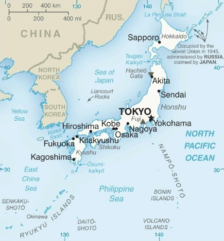
Japan is a stratovolcanic archipelago of 6,852 islands. The four largest are Honshu, Hokkaido, Kyushu, and Shikoku. Japan's population of 126 million is the world's eleventh largest. Approximately 14 million people live in Tokyo. The Greater Tokyo Area is the world's largest metropolitan area, with over 37 million residents
Japan is most populous country that does not have a land border with another country
Japan consists of 47 prefectures
Honshu
Tokyo is on River Sumida
Ginza is a shopping district in Tokyo
Tokyo Tower is an Eiffel Tower-inspired lattice tower
Completed in 2012, the Tokyo Skytree is the tallest tower in the world (634 m)
Tsukiji fish market is the biggest wholesale fish and seafood market in the world. The market is located in Tsukiji in central Tokyo
Tokyo Disneyland was the first Disney park to be built outside of the United States and opened in 1983
Shinjuku Station in Tokyo is the busiest railway station in the world
The Shinkansen, known as the bullet train, is a network of high-speed railway lines. The original Tokaido Shinkansen, connecting Tokyo, Nagoya and Osaka, is one of the world's busiest high-speed rail lines
Shibuya Crossing is a popular scramble crossing. It is located in front of the Shibuya Station Hachiko exit and stops vehicles in all directions to allow pedestrians to inundate the entire intersection
Minato is a special ward in Tokyo. It host many embassies, and the headquarters of a number of Japanese and international firms
Yasukuni Jinja is a Japanese Shinto shrine in Tokyo that is at the centre of an international controversy. It is a shrine to war dead who served the Emperor of Japan during wars from 1867–1951
The Budokan in Tokyo was the location where many "Live at the Budokan" albums were recorded
Roppingi is a district of Tokyo famous for its night clubs
Yamate Tunnel in Tokyo is the longest in-city road tunnel in the world. The overall length is 18.2 km
Tokyo International Airport, commonly known as Haneda Airport, and Narita International Airport are the two international airports serving the Greater Tokyo Area
Kanto region includes the Greater Tokyo Area and encompasses seven prefectures
Yokohama is a major commercial hub of the Greater Tokyo Area. Yokohama developed rapidly as Japan's prominent port city following the end of Japan's isolation in the mid-19th century
Kansai International Airport was built on a man-made island in Osaka
Historically a merchant city, Osaka has also been known as the ‘nation's kitchen’ and served as a centre for the rice trade during the Edo period
Hiroshima Peace Memorial (Genbaku Dome) was the only structure left standing in the area where the first atomic bomb exploded in 1945. It has been preserved in the same state as immediately after the bombing. It contains the A-Bomb Dome, Children’s Peace Monument, and Rest House. Opened in 1954
Ise Grand Shrine is a Shinto shrine dedicated to the sun goddess Amaterasu
Kashiwazaki-Kariwa, located in the Niigata Prefecture of Japan, is the largest nuclear generating station in the world by net electrical power rating
Akashi Kaikyo Bridge links Kobe on the Japanese mainland of Honshu to Iwaya on Awaji Island. It crosses the Akashi Strait and had the longest central span of any suspension bridge in the world until 2022 when the 1915 Canakkale Bridge opened in Turkey
Heian-kyo was one of several former names for Kyoto. It was the capital of Japan for over one thousand years, from 794 to 1868 with an interruption in 1180
Kiyomizu Temple is a complex of Buddhist temples in Kyoto
Ryoan-ji is a Zen temple in Kyoto with a ‘dry landscape’ garden
Iwami Ginzan mine reached its peak production in the early 17th century of approximately 38 tons of silver a year which was then a third of world production
Himeji Castle is a hilltop Japanese castle comprising a network of 83 buildings with advanced defensive systems from the feudal period. Himeji Castle is the largest and most visited castle in Japan, and it was registered in 1993 as one of the first World Heritage Sites in the country
Nara Prefecture in the Kansai Region has the distinction of having more World Heritage Listings than any other prefecture in Japan
Sika deer roam through the city of Nara
Tsugaru Strait separates Hokkaido from Honshu, although the two islands are connected by the underwater Seikan Tunnel (the longest railway tunnel in the world)
Hokkaido
Sapporo is the largest city on Hokkaido
Sapporo Snow Festival is held annually in Sapporo over seven days in February
Mount Usu is an active stratovolcano on Hokkaido
Shiretoko Peninsula is located on the easternmost portion of Hokkaido, protruding into the Sea of Okhotsk
Cape Soya is the northernmost point on Hokkaido
Kyushu
Fukuoka is the largest city on Kyushu
Kanmon Straits separates Kyushu from Honshu
Mount Aso is the largest active volcano in Japan. It stands in Aso Kuju National Park on the island of Kyushu. It also has one of the largest calderas in the world
Nagasaki became the sole port used for trade with the Portuguese and Dutch during the 16th through 19th centuries
Dejima (or Deshima) was a small artificial island built in the bay of Nagasaki in 1634 by local merchants. This island remained as the single place of direct trade and exchange between Japan and the outside world during the Edo period
Kagoshima is known as the ‘Naples of the East’
Tsushima Island is situated between the Tsushima Strait and Korea Strait, approximately halfway between Kyushu and the Korean Peninsula
Shikoku
Shikoku is south of Honshu and northeast of Kyushu
Matsuyama is the largest city on Shikoku
Mount Fuji is one of Japan's ‘Three Holy Mountains’ (Sanreizan) along with Mount Tate and Mount Haku. It is an active stratovolcano and the highest mountain in Japan, with a summit of 3,766 m
Shinano River is the longest river in Japan
Lake Biwa is the largest freshwater lake in Japan, and is over four million years old
Lake Kasumigaura is the second-largest lake in Japan
Okinawa is Japan's southernmost prefecture. Okinawa's capital, Naha, is located in the largest and most populous island, Okinawa Island. The disputed Senkaku Islands (claimed by China where they are known as Daioyu Islands, and Taiwan where they are known as Tiaoyutai Islands) are also administered as part of Okinawa Prefecture
Ryukyu Islands stretch southwest from Kyushu to Taiwan. Administratively, the islands are divided into Kagoshima Prefecture in the north and Okinawa Prefecture in the south
Seto Inland Sea is the body of water separating Honshu, Shikoku, and Kyushu
Bonin Islands, also known as the Ogasawara Islands, are an archipelago of over 30 subtropical and tropical islands, 1,000 km south of Tokyo
Iwo Jima lies south of the Bonin Islands. The highest point is Mount Suribachi
Jordan

Flag of Jordan is based on the 1916 flag of the Arab Revolt against the Ottoman Empire
| Capital | Amman |
| Largest cities | Amman, Zarqa |
| Currency | Dinar |
| Highest point | Jabal Umm ad Dami |
The Hashemite Kingdom of Jordan was known as Transjordan
In the 3rd century BC, Ptolemy II Philadelphus, Pharaoh of Ptolemaic Egypt, rebuilt the city now known as Amman and renamed it ‘Philadelphia’
Petra was described as ‘a rose-red city half as old as time’ in a sonnet by John Burgon
Petra was the capital of the ancient kingdom of Nabataea, dating from 4th century BC. The site remained unknown to the Western world until 1812, when it was introduced by Swiss explorer Johann Ludwig Burckhardt
Petra was named amongst the New7Wonders of the World in 2007
Aqaba is the largest city on the Gulf of Aqaba and is Jordan's only coastal city
Madaba’s main attraction is its Byzantine mosaics
Wadi Rum is the largest wadi in Jordan. The Wadi Rum Protected Area is a World Heritage Site
Kuwait

| Capital | Kuwait City |
| Largest cities | Kuwait City |
| Currency | Dinar |
| Highest point | Mutla Ridge |
Situated in the northern edge of Eastern Arabia at the tip of the Persian Gulf, Kuwait shares borders with Iraq and Saudi Arabia
Kuwait is a constitutional emirate with an elected parliamentary system
Bubiyan Island is the largest island in the Kuwaiti coastal island chain
Al Hamra tower in Kuwait City is the tallest building in Kuwait and the tallest curved concrete tower in the world
Kuwait Towers are a group of three slender towers in Kuwait City. The main tower is 187 m high and carries two spheres. The lower sphere holds in its bottom half a water tank of 4,500 cubic meters and in its upper half a restaurant
Kuwait has the world's sixth largest oil reserves. The Kuwaiti dinar is the highest valued currency in the world
House of Al Sabah is the ruling family of Kuwait
Kyrgyzstan

Flag of Kyrgyzstan contains a depiction of a yurt in a yellow sun
| Capital | Bishkek |
| Largest cities | Bishkek, Osh |
| Currency | Som |
| Highest point | Jengish Chokusu |
Bishkek was renamed Frunze in 1926, after the Bolshevik military leader Mikhail Frunze. In 1991, the Kyrgyzstan parliament restored the city's historical name
The main government building in Bishkek is the White House
Ala-Too Square is the central square in Bishkek. In 2005, the square was the site of the largest anti-government protest of Kyrgyzstan's Tulip Revolution
The mountainous region of the Tian Shan covers over 80% of the country
Manas International Airport is the main airport in Kyrgyzstan
Laos

| Capital | Vientiane |
| Largest cities | Vientiane |
| Currency | Kip |
| Highest point | Phou Bia |
Laos traces its history to the Kingdom of Lan Xang or ‘Land of a Million Elephants’, which existed from the 14th to the 18th century
Laos is the only landlocked country in Southeast Asia
The Mekong River forms a large part of the western boundary with Thailand
The Plain of Jars is a large group of historic cultural sites in Laos containing thousands of stone jars
Until the communist takeover in 1975, Luang Prabang was the royal capital and seat of government of the Kingdom of Laos
Luang Prabang is a World Heritage Site with numerous Buddhist temples and monasteries
Laos was bombed heavily in the Vietnam War. It holds the dubious distinction of being the most bombed country in the world
Vientiane is on a bend of the Mekong River, at which point it forms the border with Thailand
Lebanon

Flag of Lebanon is charged with a cedar tree
| Capital | Beirut |
| Largest cities | Beirut, Tripoli, Sidon, Tyre |
| Currency | Pound |
| Highest point | Qurnat as Sawda |
Lebanon is bordered by Syria to the north and east and Israel to the south
The border with the Israeli-occupied Golan Heights is disputed by Lebanon in a small area called Shebaa Farms
Baalbek is a town in the Beqaa Valley of Lebanon. It is famous for its exquisitely detailed yet monumentally scaled temple ruins of the Roman period, when Baalbek, then known as Heliopolis, was one of the largest sanctuaries in the Empire. It is Lebanon's greatest Roman treasure
The Beqaa Valley is home to Lebanon's famous vineyards and wineries
Tripoli is the largest city in northern Lebanon
Litani is the longest river in Lebanon
Byblos is one of the oldest continuously inhabited cities in the world and is a World Heritage Site
Tyre was one of the earliest Phoenician metropolises
Malaysia

The 14-point star on the flag of Malaysia is known as the Federal Star. The flag is also known as the Stripes of Glory
| Capital | Kuala Lumpur |
| Largest cities | Kuala Lumpur, Seberang Perai |
| Currency | Ringgit |
| Highest point | Mount Kinabalu |
Malaysia is separated by the South China Sea into Peninsular Malaysia and East Malaysia (Malaysian Borneo). Peninsular Malaysia shares a land border with Thailand. East Malaysia shares land borders with Brunei and Indonesia
Malaysia has moved many administrative functions from Kuala Lumpur to a suburb called Putrajaya. Kuala Lumpur remains the official capital. Putrajaya is part of a regional ‘Multimedia Super Corridor (MSC)’. The MSC itself is also home to Kuala Lumpur International Airport and the Petronas Twin Towers
Petronas Towers were the tallest buildings in the world from 1998 to 2004 and remain the tallest twin towers in the world
Merdeka 118 is a 118-story, 679 m tall skyscraper in Kuala Lumpur. It is the world's second-tallest building and should be opening in July 2023
Kuala Lumpur is at the confluence of the rivers Klang and Gombak
George Town is the capital city of the state of Penang. Named after Britain's King George III, the city is located on the northeast corner of Penang Island. George Town was the capital of the Straits Settlements
Sabah is one of the 13 member states of Malaysia, and is its easternmost state. It is located on the northern portion of the island of Borneo. It is the second largest state in the country after Sarawak, which it borders on its southwest
Kuching is the capital and the most populous city in the state of Sarawak
Mount Kinabalu on the island of Borneo is the highest mountain in the Malay Archipelago
The southernmost point of continental Eurasia, Tanjung Piai, is in Malaysia
Banggi Island is the largest island in Malaysia
Crocker Range is a mountain range on the island of Borneo. Politically, it lies within the boundary of the Malaysian state of Sabah. It contains Mount Kinabalu, the highest mountain in the Malay Archipelago
Labuan is a Federal Territory known as an offshore financial centre
First World Hotel & Plaza in Pahang is the largest hotel in the world, It has 7,351 rooms
Maldives

| Capital | Male |
| Largest cities | Male |
| Currency | Rufiyaa |
| Highest point | Villingili |
Maldives consists of 1,192 coral islands grouped in a double chain of 26 atolls. The chains stand in the Laccadive Sea 600 km southwest of India
Maldives has the lowest natural highest point in the world, at 2.4 m
Historically, Maldives provided enormous quantities of cowry shells
Ibrahim Nasir International Airport serves the Maldives
Mongolia

Flag of Mongolia has the Soyombo symbol on the leftmost stripe
| Capital | Ulaanbaatar |
| Largest cities | Ulaanbaatar |
| Currency | Tugrik |
| Highest point | Khuiten Peak |
The geography of Mongolia is varied, with the Gobi Desert to the south and with cold and mountainous regions to the north and west. Much of Mongolia consists of steppes
Mongolia has the lowest population density of all sovereign states
Oyu Tolgoi (‘Turquoise Hill’) mining project is the largest financial undertaking in Mongolia's history and is expected upon completion to account for more than 30% of the country's gross domestic product. Copper production is expected to reach 450,000 tonnes annually. Financing for the project has come in part from the Rio Tinto Group
Genghis Khan Equestrian Statue is a 40 m tall statue of Genghis Khan on horseback, on the bank of the Tuul River east of Ulaanbaatar (Ulan Bator), where according to legend, he found a golden whip
Ulaanbaatar was previously anglicised as Ulan Bator. Means “Red Hero”. It is the coldest capital city
Founded in 1639 as a nomadic Buddhist monastic centre, Ulaanbaatar is at the confluence of the Tuul and Selbe rivers
The International Airport is named after Genghis Khan
Nemegt Formation is a geological formation in the Gobi Desert, dating to the Late Cretaceous. The formation consists of river channel sediments and contains many fossils
Myanmar (Burma)

Current flag of Myanmar was adopted in 2010
| Capital | Naypyidaw |
| Largest cities | Yangon, Mandalay, Naypyidaw |
| Currency | Kyat |
| Highest point | Hkakabo Razi |
Myanmar, officially the Republic of the Union of Myanmar, is also known as Burma (the official name until 1989)
One-third of Myanmar's total perimeter forms an uninterrupted coastline along the Bay of Bengal and the Andaman Sea
Naypyidaw is the capital of Myanmar. In 2005, the administrative capital was officially moved to a greenfield site 2 miles west of Pyinmana, and approximately 200 miles north of Yangon, the previous capital. The capital's official name was announced in 2006
Naypyidaw means “city of the kings”
Yangon, also known as Rangoon ('end of strife')
Shwedagon Pagoda in Yangon is the most sacred Buddhist pagoda for the Burmese as it is believed to contain relics of four previous Buddhas
Sule Pagoda is a stupa in Yangon that served as a rallying point in the 1988 uprisings, 2007 Saffron Revolution, and 2021 Spring Revolution
Bagan Archaeological Zone has over 2000 Buddhist temples and pagodas
Nepal

The double-pennant flag of Nepal is the world's only non-quadrilateral state flag
| Capital | Kathmandu |
| Largest cities | Kathmandu |
| Currency | Rupee |
| Highest point | Mount Everest |
Nepal, officially the Federal Democratic Republic of Nepal, is bordered by China and India
The mountainous north of Nepal has eight of the world's ten tallest mountains
Hinduism is practiced by 81% of Nepalis, the highest percentage of any country
Tenzing-Hillary Airport in Lukla is ranked as the most dangerous airport in the world
Lumbini is a Buddhist pilgrimage site in Nepal. It is the place where, according to Buddhist tradition, Queen Mayadevi gave birth to Siddhartha Gautama in 623 BC
Nepal time is UTC+05:45
North Korea

| Capital | Pyongyang |
| Largest cities | Pyongyang, Hamhung |
| Currency | Won |
| Highest point | Paektu Mountain |
North Korea is officially the Democratic People's Republic of Korea (DPRK)
North Korea follows Songun, or 'military-first"' policy
Songbun is an ascribed status system based on a citizen's assessed loyalty to the government
Pyongyang means 'flat land' or 'peaceful land'
Pyongyang is located on the Taedong River
Ryugyong Hotel is a towering, empty concrete shell that was once intended for use as a hotel in Pyongyang. Construction started in 1987 and ceased in 1992. Construction resumed in 2008 and a partial opening was announced for 2013, but this was cancelled. It is the tallest unoccupied building in the world
Juche Tower is a monument in Pyongyang, named after the ideology of Juche introduced by its first leader Kim Il-sung
Rungrado 1st of May Stadium is a multi-purpose stadium on Rungra Island, Pyongyang. The stadium was originally built with an official capacity of 150,000
Grand Mass Gymnastics and Artistic Performance Arirang, also known as the Arirang Festival is a gymnastics and artistic festival held in the Rungrado 1st of May Stadium
Masikryong is a ski resort at the summit of Taehwa Peak
Heaven Lake is a crater lake within a caldera atop Mount Paektu. Supposed birthplace of Kim Jong-il
Korean Demilitarized Zone is a de facto border barrier, which runs in the vicinity of the 38th parallel north
Northern Limit Line, or NLL, is the de facto maritime boundary between North and South Korea in the Yellow Sea
Air Koryo is the North Korean national airline
Oman

Flag of Oman contains the national emblem (dagger and two swords)
| Capital | Muscat |
| Largest cities | Muscat |
| Currency | Rial |
| Highest point | Jebel Shams |
Oman is officially the Sultanate of Oman
Oman is the oldest independent Arab state
Oman is ruled by the house of Al Said
The rocky Western Al Hajar Mountains dominate the landscape of Muscat
The Madha and Musandam exclaves are surrounded by the UAE on their land borders, with the Strait of Hormuz and Gulf of Oman forming Musandam's coastal boundaries
Masirah Island is the largest island of Oman
Wahiba sands is a region of desert
Royal Opera House Muscat opened in 2011
In 2007, Oman's Arabian Oryx Sanctuary was the first site to be removed from the World Heritage list
Land of Frankincense is a World Heritage Site
Pakistan

| Capital | Islamabad |
| Largest cities | Karachi, Lahore, Faisalabad, Rawalpindi |
| Currency | Rupee |
| Highest point | K2 |
Pakistan is officially the Islamic Republic of Pakistan
Pakistan is the fifth most populous country in the world
Pakistan consists of the provinces of Balochistan, Khyber Pakhtunkhwa, Punjab, Sindh, and the federally-administered Islamabad Capital Territory. Additionally, Pakistan also administers two autonomous territories in the disputed region of Kashmir – Gilgit-Baltistan and Azad Kashmir
Pakistan is divided into three major geographic areas: the northern highlands, the Indus River plain and the Balochistan Plateau. The northern highlands contain the Karakoram, Hindu Kush and Pamir mountain ranges, which contain some of the world's highest peaks, including K2. The Balochistan Plateau lies in the west and the Thar Desert in the east. The Indus River and its tributaries flow through the country from the Kashmir region to the Arabian Sea
Islamabad (meaning ‘Abode of Islam’ or ’Abode of Peace’) is the capital of Pakistan, and is the ninth largest city in Pakistan. The city was built during the 1960s to replace Karachi as Pakistan's capital
Islamabad master plan was created by Greek architect Constantinos Doxiadis
Karachi is the capital of Sindh province as well as the largest and most populous metropolitan city of Pakistan and the main seaport and financial centre of the country. Karachi is also known as “City of Lights” mainly due to the city's night life
Mazar-e-Quaid, also known as the Jinnah Mausoleum, is the final resting place of Muhammad Ali Jinnah, the founder of Pakistan. It is in Karachi
Punjab is Pakistan's second largest province by area, after Balochistan, and its most populous province
Lahore is the capital city of Punjab
Taxila is an archaeological site in Punjab
Peshawar is the capital of Khyber Pakhtunkhwa (formerly called the North-West Frontier Province)
Rawalpindi is adjacent to Islamabad. It was briefly the country's capital while Islamabad was being constructed
Gwadar Port is situated on the Arabian Sea. It features prominently in the China–Pakistan Economic Corridor (CPEC) plan
Ranikot Fort, known as ‘The Great Wall of Sindh’, is the largest fort in the world
Waziristan is a mountainous region of northwest Pakistan, bordering Afghanistan. It comprises the area west and southwest of Peshawar
Cholistan Desert adjoins the Thar Desert
Mangla Dam is located on the Jhelum River
Mohenjo-Daro, meaning 'Mound of the Dead Men', is an archaeological site in Sindh province and was one of the largest settlements of the Indus Valley Civilisation
Tarbela Dam on the Indus river is the largest earth-filled dam in the world
Baltoro Glacier runs through part of the Karakoram mountain range
Philippines

| Capital | Manila |
| Largest cities | Quezon City, Manila, Davao City |
| Currency | Peso |
| Highest point | Mount Apo |
Philippines consists of 7,107 islands that are categorized broadly under three main geographical divisions: Luzon, Visayas, and Mindanao
Philippines was named in honour of King Philip II of Spain
Luzon is the largest island. With a population of 64 million, it is the fourth most populous island in the world after Java, Honshu and Great Britain
Manila is on the island of Luzon
Quezon City is part of Metro Manila
Mount Pinatubo is an active stratovolcano in the Cabusilan Mountains on the island of Luzon. Erupted in 1991
Davao City is the largest city in Mindanao
Metro Cebu is the main urban centre of the island province of Cebu. Includes Cebu City and Lapu-Lapu City
Chocolate Hills is a group of over 1,000 hills. They are covered in green grass that turns brown during the dry season, hence the name
Taal Lake is a freshwater lake on the island of Luzon. The lake fills Taal Caldera, a large volcanic caldera formed by very large eruptions between 500,000 and 100,000 years ago
Palawan is an archipelago and is the largest province in terms of total area
The longest river is the Cagayan River in northern Luzon
Roman Catholicism is the chief religion
Qatar

Qatar's flag is the only national flag having a width more than twice its height
| Capital | Doha |
| Largest cities | Doha |
| Currency | Riyal |
| Highest point | Qurayn Aba al Bawl |
Following Ottoman rule, Qatar became a British protectorate in the early 20th century until gaining independence in 1971. Qatar has been ruled by the Al Thani family since the mid-19th century
Qatar’s sole land border is with Saudi Arabia to the south, with the rest of its territory surrounded by the Persian Gulf
Qatar is one of the world's richest country per capita
Al Jazeera headquarters are in Doha
Museum of Islamic Art, designed by I.M. Pei, is in Doha
National Museum of Qatar was designed by Jean Nouvel
Al Udeid Air Base houses Qatari Air Force, U.S. Air Force, Royal Air Force, and other foreign forces
Hamad International Airport is the main airport in Qatar
Saudi Arabia

Flag of Saudi Arabia features the shahada and a sword
| Capital | Riyadh |
| Largest cities | Riyadh, Jeddah, Mecca, Medina |
| Currency | Riyal |
| Highest point | Jabal Sawda |
Saudi Arabia is the only nation with both a Red Sea coast and a Persian Gulf coast. It was founded in 1932 by Ibn Saud
Saudi Arabia has the second largest known oil reserves, behind Venezuela
Saudi Arabia is the largest country in the world by area with no permanent rivers
Riyadh is served by King Khalid International Airport
Masmak Fort in Riyadh was captured by Ibn Saud in 1902
Jeddah is the largest sea port on the Red Sea
Jeddah Tower, previously known as Kingdom Tower, is a skyscraper construction project which is currently on hold. It is planned to be the first 1 km tall building, and the centrepiece and first phase of a development and tourist attraction known as Jeddah Economic City
Jeddah Light is the tallest lighthouse in the world (131 m)
Jeddah is served by King Abdulaziz International Airport
Hejaz is a region in the west Saudi Arabia. Defined primarily by its western border on the Red Sea, it extends from Haql on the Gulf of Aqaba to Jizan. Its main cities are Jeddah, Mecca and Medina
Ghawar is the largest oil field in the world. It is owned and operated by Saudi Aramco
Neom is the name of a future planned city to be built in the Tabuk Province of northwestern Saudi Arabia. It is planned to incorporate smart city technologies and to function as a tourist destination
The Line is a proposed smart city in Neom that will have no cars, no streets, and no carbon emissions. The city is part of the Saudi Vision 2030 project
Abraj Al-Bait Towers, also known as the Mecca Royal Hotel Clock Tower, is a building complex in Mecca. The complex's hotel tower became the third tallest building in the world in 2012, surpassing Taiwan's Taipei 101 and surpassed only by Dubai's Burj Khalifa and Shanghai's Shanghai Tower. The central hotel building has the world's largest clock face
Al-Masjid al-Haram ('Sacred Mosque'), also known as the Great Mosque of Mecca, is the largest mosque in the world
Mount Arafat is a hill 20 km from Mecca. According to some Islamic traditions, the hill is the place where the Prophet Muhammad stood and delivered the Farewell Sermon
Al-Masjid an-Nabawi ('Prophet’s Mosque') in Medina was the second mosque built in the history of Islam and is now one of the largest mosques in the world. It is the second-holiest site in Islam, after al-Masjid al-Haram in Mecca
King Fahd Causeway is a series of bridges and causeways connecting Saudi Arabia and Bahrain. Passport Island is located on the King Fahd Causeway
Al-Ahsa Oasis is the largest oasis in the world
Salwa Canal is a proposed shipping route through Saudi Arabia along its border with Qatar, effectively turning the latter into an island
Tiran Island and Sanafir Island were formerly administered by Egypt
Singapore

| Capital | Singapore |
| Largest cities | Singapore |
| Currency | Dollar |
| Highest point | Bukit Timah Hill |
Singapore is separated from Peninsular Malaysia by the Straits of Johor to the north, and from Indonesia's Riau Islands by the Singapore Strait to the south
Modern Singapore was founded in 1819 by Sir Thomas Stamford Raffles as a trading post of the East India Company. The British obtained sovereignty over the island in 1824, and Singapore became one of the British Straits Settlements in 1826
Singapore is derived from the Sanskrit word for ‘Lion City’
Esplanade – Theatres on the Bay is a waterside building located on six hectares of waterfront land alongside Marina Bay near the mouth of the Singapore River
Gardens by the Bay is a park of reclaimed land in central Singapore, adjacent to the Marina Reservoir
Marina Bay Sands is an integrated resort fronting Marina Bay in Singapore, owned by the Las Vegas Sands Corporation
ArtScience Museum is one of the attractions at Marina Bay Sands, an integrated resort in Singapore owned by the US Las Vegas Sands company
Orchard Road is an upmarket shopping area
Singapore Botanic Gardens is a tropical garden located at the fringe of the Orchard Road shopping district. It is one of three gardens, and the only tropical garden, to be honoured as a World Heritage Site
Singapore has the world's highest percentage of millionaires
Port of Singapore was also the busiest port in terms of total cargo tonnage handled until 2005, when it was surpassed by the Port of Shanghai
Singapore has four official languages: English, Malay, Mandarin Chinese, and Tamil
Jewel Changi Airport is a nature-themed entertainment and retail complex surrounded by and linked to one of the passenger terminals of Changi Airport. Its centrepiece is the world's tallest indoor waterfall, the Rain Vortex
Merlion is the national symbol of Singapore. It is depicted as a mythical creature with the head of a lion and the body of a fish
Johor-Singapore causeway links the city of Johor Bahru in Malaysia across the Straits of Johor to the town of Woodlands in Singapore
Sentosa is an island located off the southern coast of Singapore's main island. Capella Hotel on the island was the location of the 2018 North Korea–United States Singapore Summit
South Korea

Flag of South Korea is also known as the Taegukgi. It has a red and blue Taegeuk in its centre, and four black trigrams
| Capital | Seoul |
| Largest cities | Seoul, Busan, Incheon, Daegu |
| Currency | Won |
| Highest point | Hallasan |
South Korea is officially the Republic of Korea (ROK)
Half of the country's 50 million people reside in the metropolitan area surrounding its capital, the Seoul Capital Area
Jejudo (Jeju Island) is the largest island on the Korean Peninsula. It is dominated by Hallasan (Halla Mountain): a volcano 1,950 m high and the highest mountain in South Korea
Jeju Volcanic Island and Lava Tubes is a World Heritage Site
Seoul's history stretches back more than two thousand years when it was founded in 18 BC by Baekje
Seoul is situated on the Han River
Seoul is the world's most wired city. It is served by the KTX high-speed rail and the Seoul Metropolitan Subway, the world's largest subway network by route length
Seoul is divided into gu (districts). Each gu is divided into dong (neighbourhoods). Dong are divided into tong
Yeoui island in Seoul is often called "Korea's Wall Street"
Gangnam District is in Seoul. Gangnam means "South of the (Han) River"
Blue House in Seoul is the official residence of the head of state of South Korea
Lotte World Tower in Seoul is the tallest building in South Korea and the sixth tallest in the world
Seoul Gimpo Airport to Jeju City is the world’s busiest passenger air route
Incheon International Airport is the largest airport in South Korea, and is the primary airport serving the Seoul Capital Area
Incheon has led the economic development of Korea by opening its port to the outside world
Busan (or Pusan) is the largest port. The city is located on the southeastern-most tip of the Korean peninsula
Sejong was founded in 2007 as the new planned capital of South Korea. The construction of the city should be completed in 2030
Shinsegae is a department store franchise. Its flagship store in Centum City, Busan, became the world's largest department store in 2009
Pyeongchang is located in the Taebaek Mountains region
Bridge of No Return crosses the Military Demarcation Line (MDL) between North Korea and South Korea
Sri Lanka

Flag of Sri Lanka features a golden lion holding a kastane sword in a maroon background with four gold bo leaves
| Capital | Colombo (see note below) |
| Largest cities | Colombo |
| Currency | Rupee |
| Highest point | Mount Pedro |
Note: Sri Jayawardenapura Kotte is the administrative capital of Sri Lanka. It is located beyond the eastern suburbs of the commercial capital Colombo and is often called New Capital Territory
In 1972, during Sirimavo Bandaranaike's second term as prime minister, Ceylon became a republic within the Commonwealth, and the name was changed to Sri Lanka
Sinhalese and Tamil are the two official languages of Sri Lanka
Sri Lanka is separated from the Indian subcontinent by the Gulf of Mannar and Palk Strait
Adam's Bridge is a chain of limestone shoals, between Pamban Island, off the southeastern coast of Tamil Nadu, India, and Mannar Island, off the northwestern coast of Sri Lanka. Geological evidence suggests that this bridge is a former land connection between India and Sri Lanka
Sigiriya (‘lion’s rock’) is an archeological site in the central Matale District of Sri Lanka. It contains the ruins of an ancient palace complex, built during the reign of King Kasyapa (477–495 AD). Sigiriya rock is the hardened magma plug from an extinct and long-eroded volcano
Temple of the Tooth is a Buddhist temple in the city of Kandy. It is located in the royal palace complex of the former Kingdom of Kandy, which houses the relic of the tooth of Buddha
Trincomalee is a port in Sri Lanka
In Islamic tradition, Adam’s Peak is the site where Adam fell to earth and where his footprint can be found
Syria

| Capital | Damascus |
| Largest cities | Aleppo, Damascus, Homs |
| Currency | Pound |
| Highest point | Mount Hermon |
Damascus is among the oldest continuously inhabited cities in the world
Umayyad Mosque, also known as the Great Mosque of Damascus, located in the old city of Damascus, is one of the largest and oldest mosques in the world
Barada River runs through Damascus
Homs is the known as the “capital of the revolution” after residents embraced the call to overthrow the president in 2011
Homs is located on the Orontes River
Palmyra was an ancient Semitic city, located in Homs Governorate. Its extensive ruins include remains of the Great Colonnade, the Temple of Bel, the Camp of Diocletian and the Roman Theatre
The Dead Cities or Forgotten Cities are a group of 700 abandoned settlements in northwest Syria between Aleppo and Idlib. Most villages, which date from the 1st to 7th centuries, became abandoned between the 8th and 10th centuries
Autonomous Administration of North and East Syria, also known as Rojava, is a de facto autonomous region in northeastern Syria
During the Syrian Civil War, Raqqa was captured in 2013 by the Syrian opposition and then by the Islamic State. ISIS made the city its capital in 2014
Mount Hermon’s summit straddles the border between Syria and Lebanon
Taiwan

Flag of Taiwan is known as the Blue Sky, White Sun, and a Wholly Red Earth
| Capital | Taipei |
| Largest cities | New Taipei City |
| Currency | Dollar |
| Highest point | Yu Shan |
Taiwan, officially the Republic of China (ROC), is a sovereign state. The Republic of China, originally based in mainland China, now governs the island of Taiwan. The People’s Republic of China also asserts itself to be the sole legal representation of China and claims Taiwan as its 23rd province to be under its sovereignty
Nine-dotted line refer to the demarcation line used initially by the government of Taiwan, and subsequently also by the government of China, for their claims of the major part of the South China Sea. The contested area includes the Paracel Islands, the Spratly Islands, and various other areas including the Pratas Islands, the Macclesfield Bank and the Scarborough Shoal
Yu Shan is also known as Jade Mountain
National Palace Museum in Taipei has a large permanent collection of ancient Chinese artefacts and artworks
Taipei 101 was the world's tallest building from its opening in 2004 until 2010
Taipei, New Taipei and Keelung form the largest metropolitan area of Taiwan
Taiwan also includes the Penghu, Kinmen, and Matsu islands
Taichung Power Plant is the fourth-largest coal-fired power station in the world
Tajikistan

Flag of Tajikistan depicts a crown surmounted by an arc of seven stars
| Capital | Dushanbe |
| Largest cities | Dushanbe. Khujand |
| Currency | Somoni |
| Highest point | Ismail Somoni Peak |
Mountains cover more than 90% of Tajikistan
Dushanbe means "Monday" in the Tajik language. The city developed on the site of a Monday marketplace village and was known as Stalinabad between 1929 and 1961
Dushanbe Flagpole is the second tallest free-standing flagpole in the world, after the Jeddah Flagpole
Ismail Somoni Peak was known as Communism Peak until 1998
Lenin Peak is the second highest mountain in Tajikistan
Pamir Mountains lie mostly in Tajikistan
Fedchenko glacier in Tajikistan is the longest glacier in the world outside of the polar regions
Nurek Dam on the Vakhsh River is currently the second tallest man-made dam in the world, behind the Jinping-I Dam in China. The Rogun Dam, also along the Vakhsh in Tajikistan, may exceed it in size when completed
Thailand

| Capital | Bangkok |
| Largest cities | Bangkok |
| Currency | Baht |
| Highest point | Doi Inthanon |
Southern Thailand consists of the narrow Kra Isthmus that widens into the Malay Peninsula
Chao Phraya and the Mekong River are the water courses of rural Thailand
Chao Phraya flows through Bangkok and then into the Gulf of Thailand
Thailand is the only country in SE Asia never to have been colonized by a European power
In 2006, Suvarnabhumi Airport became Bangkok's official international airport, replacing Don Muang
Bangkok is known as the “Venice of the East”
Bangkok is known in Thailand as Krung Thep
Khao San Road is a backpacker centre in Bangkok
MahaNakhon is a skyscraper in Bangkok that is known for its unique pixelated design, which features a spiral cutout that runs from the top to the bottom of the building
Wat Arun, the Erawan Shrine, and the Wat Phra Kaew (home to the Emerald Buddha) are all major religious sites in Bangkok
Bang Kwang Central Prison is known as the “Bangkok Hilton”
Chiang Mai is the largest city in northern Thailand
River Kwai is in western Thailand. The bridge of the Burma Railway crosses the river
Phuket is the largest island in Thailand and is located in the Andaman Sea. Since the 1980s, the sandy beaches on the west coast of the island have been developed as tourist destinations, with Patong, Karon, and Kata being the most popular
Ayutthaya historical park covers the ruins of the old city of Ayutthaya, which was founded in 1350
Phi Phi islands are an island group between the island of Phuket and the Straits of Malacca
First Thai–Lao Friendship Bridge crosses the Mekong. Opened in 1994
Kra Isthmus is the narrowest part of the Malay Peninsula
Timor-Leste (East Timor)

| Capital | Dili |
| Largest cities | Dili |
| Currency | US dollar |
| Highest point | Tatamailau |
East Timor or Timor-Leste, officially the Democratic Republic of Timor-Leste, comprises the eastern half of the island of Timor, the nearby islands of Atauro and Jaco, and Oecusse, an exclave within Indonesian West Timor
Timor-Leste was colonised by Portugal in the 16th century. It gained independence from Indonesia in 2002
Timor-Leste is the only Asian country that lies completely in the southern hemisphere
The island of Timor is the largest and easternmost of the Lesser Sunda Islands
The two official languages are Portuguese and Tetum
Dili is the chief port and commercial centre
97% of the population of Timor-Leste are Catholics
Turkmenistan

The red stripe on the flag of Turkmenistan contains five carpet designs
| Capital | Ashgabat |
| Largest cities | Ashgabat |
| Currency | Manat |
| Highest point | Ayrybaba |
Turkmenistan possesses the world's fourth-largest reserves of natural gas and substantial oil resources
Galkynysh Gas Field is the world's second largest gas field
Darvaza gas crater, also known as the Door to Hell or Gates of Hell, is a burning natural gas field collapsed into a cavern
Karakum Desert occupies 80% of the area of Turkmenistan
Ashgabat was known as Poltoratsk between 1919 and 1927
First Baha'i House of Worship was completed in Ashgabat in 1908
Monument of Neutrality was built in 1998 on the orders of President Niyazov. The monument was topped by a 12 m tall gold-plated statue of Niyazov which rotated to always face the sun. It was dismantled and moved in 2010
Merv was a major city on the Silk Road. The site of ancient Merv is a World Heritage Site
Nisa was the first capital of the Parthians
United Arab Emirates

| Capital | Abu Dhabi |
| Largest cities | Dubai, Abu Dhabi, Sharjah |
| Currency | Dirham |
| Highest point | Jebel Jais |
Established in 1971, the country is a federation of seven emirates. The constituent emirates are Abu Dhabi (which serves as the capital), Ajman, Dubai, Fujairah, Ras al-Khaimah, Sharjah, and Umm al-Quwain. Each emirate is governed by an absolute monarch who jointly form the Federal Supreme Council
Formerly known as the Trucial States, the UAE were a British protectorate from 1820 until independence in 1971
The land border with Qatar is 19 km; however, it is a source of ongoing dispute
The largest emirate, Abu Dhabi, accounts for 87% of the UAE's total area
Masdar is a project in Abu Dhabi. Its core is a planned city, which is being built by the Abu Dhabi Future Energy Company. Designed by Foster and Partners, the city will rely entirely on solar energy and other renewable energy sources, with a sustainable, zero-carbon, zero-waste ecology
Capital Gate is a skyscraper in Abu Dhabi that was designed to incline 18° west. It is adjacent to the Abu Dhabi National Exhibition Centre
Ferrari World Abu Dhabi is an amusement park located on Yas Island in Abu Dhabi. It claims to be the largest indoor theme park in the world. Includes Formula Rossa, the world's fastest roller coaster
When completed, Saadiyat Island is expected to become Abu Dhabi's cultural centre, with eight museums
Sheikh Zayed Mosque in Abu Dhabi can hold 41,000 people
Burj al-Arab is the tallest building in the world used exclusively as a hotel (321 m). It is the first '7 star' hotel, on an island close to Jumeirah beach, in Dubai. Chief designer was Tom Wright of WS Atkins
Burj Khalifa in Dubai is the tallest man-made structure in the world, at 829.8 m. Designed by Adrian Smith of Skidmore, Owings & Merrill
A major island building project called ‘The World’ is being constructed off the coast of Dubai. It is a collection of 300 small private islands of varying sizes for individual development. The islands together form a large map of the world. Construction began in 2003, only to halt due to the 2008 financial crisis
Falcon City of Wonders, announced in 2005, is a project being built in Dubai that will feature life-size replicas of the Seven Wonders of the World and other famous monuments such as the Eiffel Tower, the Taj Mahal and the Leaning Tower of Pisa. As of 2022, the project has only completed the Left Wing of the city, with major portions still on hold
Dubai Mall is the second largest mall in the world after the Iran Mall by total land area
Ain Dubai is the world’s largest Ferris wheel. Opened in 2021
Expo 2020 was hosted by Dubai
Dubai Creek Tower is an observation tower that is under construction. It will be the world’s tallest structure when completed
Dubai International Airport is the world's busiest airport for international traffic
Dubai Miracle Garden is currently the world's largest flower garden
Palm Jumeirah is an artificial archipelago off the coast of Dubai
Sharjah is the third largest and third most populous city in the United Arab Emirates
Kalba was a Trucial State that did not become part of the UAE. It is an exclave of Sharjah
Ajman is the smallest of the emirates by area
Uzbekistan

The flag of Uzbekistan has twelve white stars
| Capital | Tashkent |
| Largest cities | Tashkent, Samarkand |
| Currency | Som |
| Highest point | Khazret Sultan |
Uzbekistan is the only Central Asian state to border all the other four “stans” (stan means ‘land of’)
Tashkent means “stone city”. After its destruction by Genghis Khan in 1219, the city was rebuilt and profited from the Silk Road. In 1865 it was conquered by the Russian Empire
Registan was the heart of the ancient city of Samarkand. It was a public square framed by three madrasahs of distinctive Islamic architecture
Gur-e-Amir is the mausoleum of Timur, in Samarkand
Located on the Silk Road, Bukhara has long been a centre of trade, scholarship, culture, and religion. The historic centre of Bukhara, which contains numerous mosques and madrasahs, is a World Heritage Site
Termez is the site of Alexander the Great's city Alexandria on the Oxus
Muruntau gold deposit is situated in the Qizilqum Desert. It is being mined in the world's largest open-pit gold mine
Namangan is an important craft and trade centre in the Fergana Valley
Karakalpakstan is an autonomous republic of Uzbekistan. It occupies the whole northwestern end of Uzbekistan. The capital is Nukus
Vietnam

| Capital | Hanoi |
| Largest cities | Ho Chi Minh City, Hanoi, Haiphong |
| Currency | Dong |
| Highest point | Fansipan |
Vietnam was called Annam until 1945
Ho Chi Minh City is located near the Mekong Delta. Under the name Prey Nokor, it was the main port of Cambodia, before being annexed by the Vietnamese in the 17th century. Under the name Saigon, it was the capital of the French colony of Cochinchina, and later of the independent state of South Vietnam from 1954 to 1975
Ho Chi Minh City surrounds the Saigon River
Landmark 81 is a skyscraper in Ho Chi Minh City. It is the tallest building in Vietnam
Hanoi is 1000 years old. Originally called Thang Long (‘Ascending Dragon’)
Hanoi served as the capital of French Indochina from 1902 to 1954. From 1954 to 1976, it was the capital of North Vietnam, and it became the capital of a reunified Vietnam in 1976
Hanoi is on the Red River
Hoa La prison is known as the “Hanoi Hilton”
Haiphong is northern Vietnam's most important seaport
Hue in Vietnam is well known for its historic monuments, and it is a World Heritage Site
Son Doong in Vietnam is one of the world’s largest natural caves
Ha Long Bay is a World Heritage Site featuring thousands of limestone karsts
Kinh are the majority ethnic group of Vietnam, comprising 86% of the population
Yemen

| Capital | Sana’a |
| Largest cities | Sana’a |
| Currency | Rial |
| Highest point | Jabal An-Nabi Shu’ayb |
The Old City of Sanaa has a distinctive architectural character, most notably expressed in its multi-storey buildings decorated with geometric patterns
Great Mosque of Sana’a dates back to the 7th century, the period of Muhammad
Aden is a seaport city, located by the eastern approach to the Red Sea (the Gulf of Aden)
Aden was the capital of the People's Democratic Republic of Yemen until unification with the Yemen Arab Republic, and again briefly served as Yemen's temporary capital during the aftermath of the 2014–15 Yemeni coup d'état
Shibam is surrounded by a fortified wall. Known for its mudbrick-made high-rise buildings, it is known as the “Manhattan of the Desert”
Hodeidah is the principal port of Yemen on the Red Sea
Socotra is an island in the Indian Ocean owned by Yemen. It is home to some of the world’s most bizarre plants including the dragon’s blood tree
Kamaran Island is the largest Yemeni island in the Red Sea
Hanish Islands is an archipelago in the Red Sea. The archipelago is largely under the control of Yemen, with a few islets granted to Eritrea
States with limited recognition
Palestine

State of Palestine is a de jure sovereign state. The State of Palestine claims the West Bank and Gaza Strip, and has designated Jerusalem as its capital, with partial control of those areas assumed in 1994 as the Palestinian Authority
Jericho is located 258 m below sea level in an oasis in Wadi Qelt in the Jordan Valley, which makes it the lowest city in the world
Allenby Bridge crosses the Jordan River near the city of Jericho, and connects the West Bank with Jordan. Known officially in Jordan as the King Hussein Bridge
Bethlehem is a city in the West Bank, Palestine, located about 10 km south of Jerusalem
Physical Geography
Regions
Transoxania is the ancient name used for the portion of Central Asia corresponding approximately with modern-day Uzbekistan, Tajikistan, southern Kyrgyzstan and southwest Kazakhstan. It is the region between the Amu Darya and Syr Darya rivers
Coromandel Coast is the southeastern coast of the Indian Subcontinent between Cape Comorin and False Divi Point. It may also include the southeastern coast of the island of Sri Lanka
Balochistan or Baluchistan is an arid region located in the Iranian Plateau in southwest Asia and south Asia, between Iran, Pakistan and Afghanistan. The area is named after the numerous Baloch tribes, an Iranian people, who moved into the area from the west around AD 1000
Makran is a semi-desert coastal strip in the south of Balochistan, in Iran and Pakistan, along the coast of the Arabian Sea and the Gulf of Oman
Fergana Valley is a depression in Central Asia, between the mountain systems of the Tien-Shan in the north and the Gissar-Alai in the south. It spreads across Uzbekistan, Kyrgyzstan and Tajikistan
Malay Archipelago includes Indonesia, the Philippines, Brunei, East Malaysia and East Timor
Mountains

Highest mountains in Asia – Everest, K2, Kangchenjunga, Lhotse, Makalu
Mount Everest is called Sagarmatha (Sanskrit for “Goddess of the Sky”) in Nepal. Known as Mount Qomolangma in China. Its peak is 8,848 m (29,029 ft) above sea level. Named after George Everest, the Surveyor General of India from 1830 to 1843. Tenzing Norgay and Edmund Hillary made the first official ascent of Everest in 1953 using the southeast ridge route. Mount Everest was known as Peak XV
K2 (so called because it is the second peak to be mapped in the Karakoram segment of the Himalayan range) has an altitude of 8,611 m. First climbed in 1954 by two Italians – Lacedelli and Compagnoni. Currently K2 is under Pakistani administration. Also known as Savage Mountain and Mount Godwin-Austen
Masherbrum mountain was the first mapped peak in the Karakoram mountain range and was formerly known as K1
Kangchenjunga is the third highest mountain in the world with an altitude of 8,586 m. It is located on Nepal's eastern border with the state of Sikkim in India. First climbed in 1955 by George Band and Joe Brown. Means ‘The Five Treasures of Snows’
Pamir Mountains are a mountain range in Central Asia formed by the junction of the Himalayas with Tian Shan, Karakoram, Kunlun, and Hindu Kush ranges. They are among the world’s highest mountains, and are known as the “Roof of the World”
Altai Mountains are a mountain range in East-Central Asia, where Russia, China, Mongolia and Kazakhstan come together, and where the rivers Ob has its source
Tian Shan is a mountain range located in Central Asia. The range lies to the north and west of the Taklamakan Desert in the border region of Kazakhstan, Kyrgyzstan and the Xinjiang Uyghur Autonomous Region of western China. In the south it links up with the Pamir Mountains
Jengish Chokusu (‘Victory Peak’) is the highest point in the Tian Shan
Appapurna is a section of the Himalayas in north-central Nepal. It was first climbed by Maurice Herzog in 1950 and was the first peak over 8,000 m to be climbed
Siachen glacier is located in the eastern Karakoram. The glacier's region is the highest battleground on Earth, where Pakistan and India have fought intermittently since 1984
Hindu Kush is an 800 km long mountain range that stretches between central Afghanistan and northern Pakistan
Tirich Mir is the highest point in the Hindu Kush, and the highest point outside the Himalayas-Karakorum range
Mount Kinabalu is a prominent mountain on the island of Borneo. It is the highest mountain in the Malay Archipelago
Zagros Mountains are the largest mountain range in Iran and Iraq. Mount Dena, the highest point in Zagros mountains, is in Iran
Khyber Pass is a mountain pass connecting Afghanistan and Pakistan, cutting through the northeastern part of the Spin Ghar mountains. An integral part of the ancient Silk Road, it is one of the oldest known passes in the world
Mount Paektu is the highest mountain in the Korean peninsula. It is an active volcano on the border between North Korea and China
Klyuchevskaya Sopka is the highest mountain on the Kamchatka Peninsula and the highest active volcano of Eurasia
Kunlun Mountains form the northern boundary of the Tibetan plateau and extend for over 3000 km. Described as the location of the Shangri-La monastery in the novel ‘Lost Horizon’
The Karakoram Highway (KKH) is the highest paved international road in the world. It connects China and Pakistan across the Karakoram mountain range, through the Khunjerab Pass at an altitude of 4,693 m
Deserts
Arabian Desert is the largest desert in Asia
Gobi Desert is a cold desert and grassland region in northern China and southern Mongolia. The desert is expanding through desertification, most rapidly on the southern edge into China. Gobi is a Mongolian word for ‘waterless place’
The Kyzyl Kum also called Qyzylqum, is the 11th largest desert in the world. Its name means ‘red sand’ in both Uzbek and Kazakh. It is divided between Kazakhstan, Uzbekistan and (partly) Turkmenistan
Rub' al Khali or Empty Quarter is one of the largest sand deserts in the world, encompassing most of the southern third of the Arabian Peninsula, including southern Saudi Arabia, and areas of Oman, the United Arab Emirates and Yemen
Thar Desert, also known as the Great Indian Desert, is a large, arid region in the northwestern part of the Indian subcontinent that forms a natural boundary between India and Pakistan
Karakum Desert is situated in Turkmenistan and Kazahkstan
Aral Karakum Desert is a desert in Kazakhstan, situated northeast of the Aral Sea
Aralkum Desert is a desert that has appeared since 1960 on the seabed once occupied by the Aral Sea
Syrian Desert includes parts of southern Syria, eastern Jordan, northern Saudi Arabia, and western Iraq
Rivers
Longest rivers in Asia – Yangtze, Yellow (Huang He), Amur, Mekong
Yangtze River is the longest river in Eurasia, the third-longest in the world, and the longest in the world to flow entirely within one country
Yellow River the sixth-longest river system in the world
Amur River is the world's tenth longest river, forming the border between the Russian Far East and Northeastern China. Empties into Sea of Okhotsk
Mekong River is the 12th longest river in the world, and the 10th largest by volume. From Tibet it runs through China's Yunnan province, Myanmar, Thailand, Laos, Cambodia and Vietnam. All except China and Myanmar belong to the Mekong River Commission. Forms the border of Burma and Laos for about 100 km
Naga fireballs, also known as Mekong lights, is a phenomenon said to be often seen on the Mekong River. Glowing balls are alleged to naturally rise from the water high into the air
Brahmaputra River flows across Tibet to break through the Himalayas and into India. It flows through the Assam Valley and south through Bangladesh. In the Ganges Delta it merges with the Padma, then the Meghna, before emptying into the Bay of Bengal
Ganges Delta is a river delta in the South Asia region of Bengal, consisting of Bangladesh and the state of West Bengal, India. It is the world's largest delta
The Sundarbans, claimed to be the largest single block of tidal halophytic mangrove forest in the world, lies at the mouth of the Ganges and is spread across areas of Bangladesh and West Bengal, India
Panj River starts on the border between Afghanistan and Tajikistan in the ancient region of Badakhshan
Yalu River (Chinese) or the Amnok River (Korean) forms part of the border between China and North Korea
Tumen River serves as part of the boundary between China, North Korea and Russia, rising on the slopes of Mount Paektu and flowing into the Sea of Japan
Tigris is 1,850 km long, rising in the Taurus Mountains of eastern Turkey. The river then flows for 400 km through Turkish territory before becoming the border between Syria and Turkey. It then flows through Iraq. Baghdad stands on the banks of the Tigris
Originating in eastern Turkey, the Euphrates flows through Syria and Iraq to join the Tigris in the Shatt al-Arab, which empties into the Persian Gulf
Salween River flows from the Tibetan Plateau into the Andaman Sea. It drains a narrow and mountainous watershed that extends into China, Burma and Thailand
Amu Darya, also called the Amu or Amo River, and historically known by its Latin name Oxus, rises in the Pamir Mountains flows into the southern remnants of the Aral Sea
Syr Darya originates in the Tian Shan Mountains in Kyrgyzstan and eastern Uzbekistan and flows for 2,200 km to the northern remnants of the Aral Sea
Indus River rises in mountain springs in Tibet, flows northwest through the disputed region of Kashmir, and flows south through Pakistan, before emptying into the Arabian Sea near Karachi. 70% of the river is in Pakistan
The five rivers of the Punjab (Jhelum, Chenab, Ravi, Sutlej, and Beas) are all tributaries of the Indus
Lakes
Aral Sea was an endorheic lake lying between Kazakhstan to its north and Uzbekistan to its south which had largely dried up by the 2010s. It began shrinking in the 1960s after the rivers that fed it (the Amu Darya and the Syr Darya) were diverted by Soviet irrigation projects
Dead Sea is a salt lake between the West Bank and Israel to the west, and Jordan to the east, and is both the lowest point in Eurasia at 429 m below sea level, and the deepest hypersaline lake in the world at 304 m deep. It is also one of the saltiest bodies of water on Earth with a salinity of about 30%. Beginning in the 1960s, water inflow to the Dead Sea from the Jordan River was reduced as a result of large-scale irrigation and generally low rainfall
Lisan Peninsula is a large spit of land that separates the North and the South basins of the Dead Sea
Lake Urmia is an endorheic salt lake in Iranian Azerbaijan, Iran and near Iran's border with Turkey. It has shrunk to 10% of its’ original size
Issyk-Kul in Kyrgyzstan is the second largest mountain lake in the world after Titicaca. It is the seventh-deepest lake in the world, the tenth-largest lake in the world by volume (though not in surface area) and the second-largest saline lake after the Caspian Sea. The lake is a Ramsar site of globally significant biodiversity
Seas
Straits of Johor separates the Malaysian state of Johor to the north from Singapore to the south
Banda Sea surrounds the Maluku Islands of Indonesia
Karimata Strait lies between Sumatra and Borneo
Strait of Malacca lies between Sumatra and Malaysia
Java Trench is the deepest point of the Indian Ocean
Java Sea lies between the Indonesian islands of Borneo to the north, Java to the south; Sumatra to the west, and Sulawesi to the east
Sulu Sea lies to the southwest of the Philippines
Sebatik Island is an island off the eastern coast of Borneo, partly within Indonesia and partly within Malaysia
Luzon Strait separates Taiwan from the Philippines
Solomon Sea lies between Papua New Guinea and the Solomon Islands
La Perouse Strait lies between Sakhalin and Hokkaido, and connects the Sea of Japan on the west with the Sea of Okhotsk on the east
Strait of Tartary connects the Sea of Okhotsk to the Sea of Japan
Sakhalin is located 6.5 km off the southeastern coast of Russia's Khabarovsk Krai, and 40 km north of Japan's Hokkaido. A marginal island of the West Pacific, Sakhalin divides the Sea of Okhotsk to its east from the Sea of Japan to its southwest. It is administered as part of Sakhalin Oblast and is the largest island of Russia
Southern Sakhalin, along with the Kuril Islands and Japan, were the indigenous lands of the Ainu peoples before they were displaced by force
The Kuril Islands in Russia's Sakhalin Oblast region stretch approximately 1,300 km northeast from Hokkaido to Kamchatka separating the Sea of Okhotsk from the North Pacific Ocean. There are 56 islands in total. All of the islands are currently under Russian jurisdiction. Japan claims the two southernmost large islands (Iturup and Kunashir) as part of its territory. Atlasov Island is an almost perfect volcanic cone rising sheer out of the sea
Strait of Hormuz is a stretch of ocean between the Gulf of Oman in the southeast and the Persian Gulf in the southwest. On the north coast is Iran and on the south coast is the United Arab Emirates and Musandam, an exclave of Oman. The strait at its narrowest is 21 miles wide
The northern end of the Red Sea is bifurcated by the Sinai Peninsula, creating the Gulf of Suez in the west and the Gulf of Aqaba to the east. Gulf of Aqaba lies west of the Arabian mainland. Egypt, Israel, Jordan, and Saudi Arabia all have coastlines on the Gulf of Aqaba
Bab-el-Mandeb is a strait located between Yemen, and Djibouti and Eritrea. It connects the Red Sea to the Gulf of Aden
South Pars/North Dome field is a natural gas condensate field located in the Persian Gulf. It is the world's largest gas field, shared between Iran and Qatar
Laccadive Sea is a body of water bordering India (including its Lakshadweep islands), the Maldives, and Sri Lanka. It is located to the west of Kerala
Gulf of Mannar is part of the Laccadive Sea
Palk Strait separates Sri Lanka from Tamil Nadu in India
Gulf of Tonkin borders Vietnam and China. The Red River empties into the Gulf of Tonkin
South China Sea encompasses an area from the Singapore and Malacca Straits to the Strait of Taiwan
Taiping Island is the largest of the naturally occurring Spratly Islands in the South China Sea. It is administered by the Republic of China
Liancourt Rocks are a group of small islets in the Sea of Japan (East Sea). Sovereignty over the islets is disputed between Japan and South Korea
Scarborough Shoal or Scarborough Reef, also known as Huangyan Island, is a disputed territory in the South China Sea claimed by the People's Republic of China, Taiwan, and the Philippines